
PS/EARTH SCIENCE
The University of the State of New York
REGENTS HIGH SCHOOL EXAMINATION
PHYSICAL SETTING
EARTH SCIENCE
Wednesday, January 28, 2009 — 9:15 a.m. to 12:15 p.m., only
This is a test of your knowledge of Earth science. Use that knowledge to answer
all questions in this examination. Some questions may require the use of the Earth
Science Reference Tables. The Earth Science Reference Tables are supplied separately.
Be certain you have a copy of the 2001 Edition (Revised November 2006) of these
reference tables before you begin the examination.
Your answer sheet for Part A and Part B–1 is the last page of this examination
booklet. Turn to the last page and fold it along the perforations. Then, slowly and
carefully, tear off your answer sheet and fill in the heading.
The answers to the questions in Part B–2 and Part C are to be written in your
separate answer booklet. Be sure to fill in the heading on the front of your answer
booklet.
You are to answer all questions in all parts of this examination according to the
directions provided in the examination booklet. Record your answers to the Part A
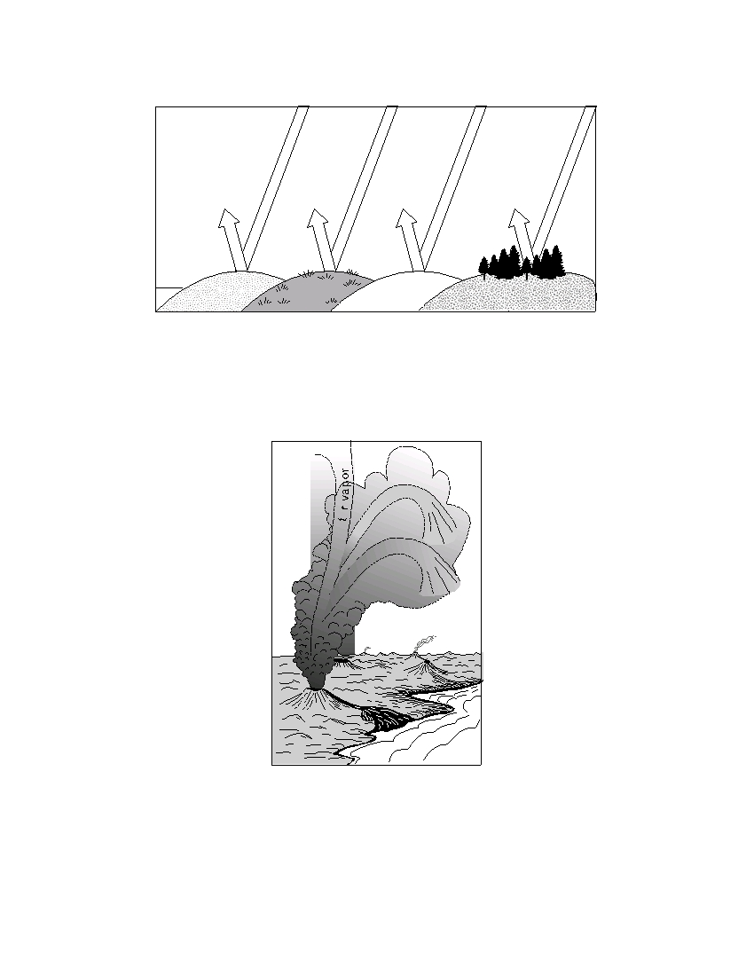
and Part B–1 multiple-choice questions on your separate answer sheet. Write your
answers to the Part B–2 and Part C questions in your answer booklet. All work should
be written in pen, except for graphs and drawings, which should be done in pencil.
You may use scrap paper to work out the answers to the questions, but be sure to
record all your answers on your separate answer sheet and in your answer booklet.
When you have completed the examination, you must sign the statement printed
at the end of your separate answer sheet, indicating that you had no unlawful
knowledge of the questions or answers prior to the examination and that you have
neither given nor received assistance in answering any of the questions during the
examination. Your answer sheet and answer booklet cannot be accepted if you fail to
sign this declaration.
Notice. . .
A four-function or scientific calculator and a copy of the 2001 Earth Science Reference Tables
(Revised November 2006) must be available for you to use while taking this examination.
The use of any communications device is strictly prohibited when taking this
examination. If you use any communications device, no matter how briefly, your
examination will be invalidated and no score will be calculated for you.
DO NOT OPEN THIS EXAMINATION BOOKLET UNTIL THE SIGNAL IS GIVEN.
E C N E I C S H T R A E / S P
Part A
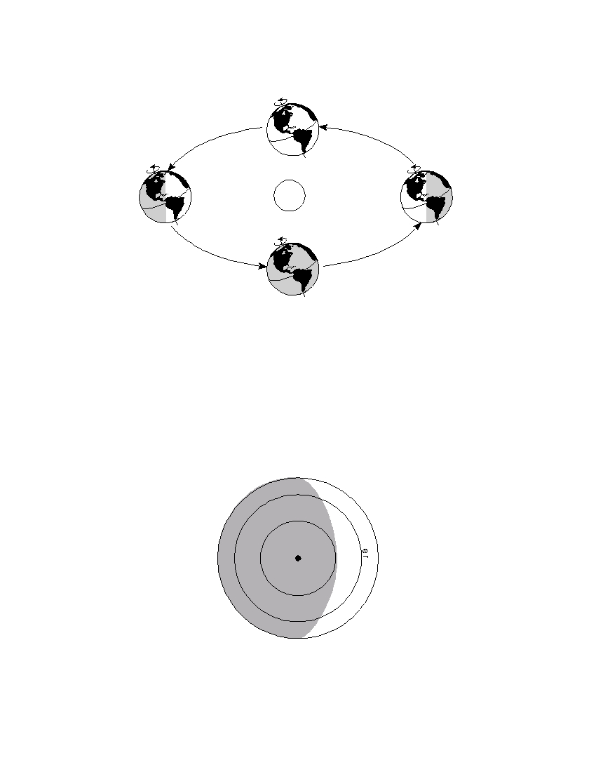
Answer all questions in this part.
Directions (1–35): For each statement or question, write on your separate answer sheet the number of the
word or expression that, of those given, best completes the statement or answers the question. Some questions
may require the use of the Earth Science Reference Tables .
1 Which statement describes the general relation-
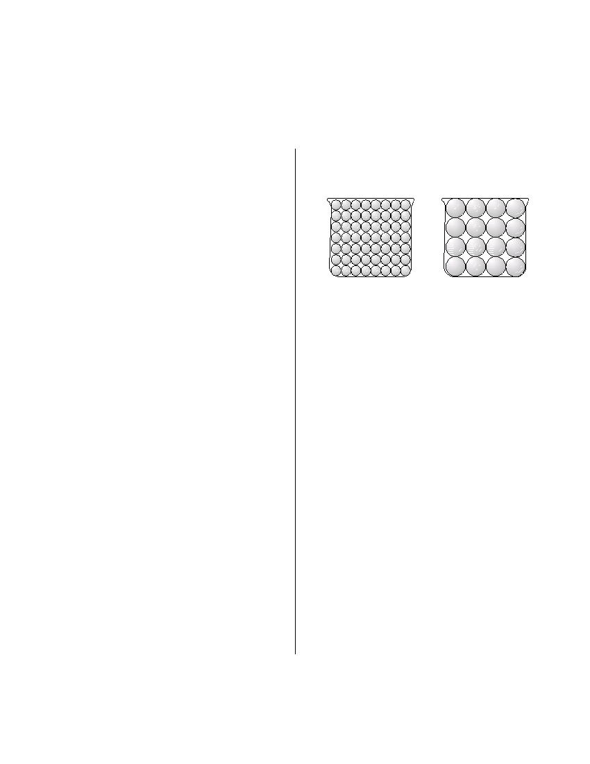
7 The diagram below shows two identical containers
ship between the temperature and the luminosity
filled with uniform particles that were sorted by
of main sequence stars?
size.
(1) As temperature decreases, luminosity increases.
(2) As temperature decreases, luminosity remains
the same.
(3) As temperature increases, luminosity increases.
(4) As temperature increases, luminosity remains
the same.
2 Which planet has the least distance between the
two foci of its elliptical orbit?
Which characteristic is most likely the same for
these particle-filled containers?
(1) Venus
(3) Mars
(2) Earth
(4) Jupiter
(1) infiltration rate
(3) capillarity
(2) water retention
(4) porosity
3 Earth’s rate of rotation is approximately
8 Which soil conditions normally result in the
(1) 1° per day
(3) 180° per day
greatest amount of runoff?
(2) 15° per day
(4) 360° per day
(1) low permeability and gentle slope
(2) low permeability and steep slope
4 Light and other forms of electromagnetic
(3) high permeability and gentle slope
radiation are given off by stars using energy
(4) high permeability and steep slope
released during
(1) nuclear fusion
(3) convection
9 Very cold climates occur at Earth’s North and
(2) conduction
(4) radioactive decay
South Poles because the polar regions
(1) are usually farthest from the Sun
5 The path of a Foucault pendulum provides
(2) absorb the greatest amount of insolation
evidence that Earth
(3) receive the most hours of daylight
(1) rotates on its axis
(4) receive low-angle insolation
(2) revolves in its orbit
(3) is tilted on its axis
10 A barometric pressure of 1021.0 millibars is equal
(4) has an elliptical orbit
to how many inches of mercury?
(1) 29.88
(3) 30.25
6 What time is it in Greenwich, England (at 0° longi-
(2) 30.15
(4) 30.50
tude), when it is noon in Massena, New York?
(1) 7 a.m.
(3) 5 p.m.
(2) noon
(4) 10 p.m.
P.S./E. Sci.–Jan. ’09
[2]
11 The diagrams below show apparent changes in the positions of the stars in the Big Dipper that have
occurred in the past 200,000 years. The directions of individual star movements as seen from Earth are
shown by the arrows.
A
B
C
G
A
B
C
D
D
G
E
F
E
F
As it was 200,000 years ago
As it is today
Which diagram best represents how the Big Dipper will appear when viewed from
Earth in 200,000 years?
B
B
C
E
A
D
A
C
D
E
F
G
G
F
( 1 )
( 3 )
C
A
B
G
G
D
C
E
D
A
B
F
E
F
( 2 )
( 4 )
12 On which station model would the present weather symbol * most likely be found?
70
28
30
48
69
16
29
42
( 1 )
( 2 )
( 3 )
( 4 )
P.S./E. Sci.–Jan. ’09
[3]
[OVER]
13 The letters A through D in the cross section below represent four of the processes that are part of the water
cycle.
A
B
D
Runoff
water
C
Groundwater
Lake
Water absorbed by roots
Which table correctly matches each letter with the process that it represents?
Letter
Process
Letter
Process
A
condensation
A
transpiration
B
precipitation
B
precipitation
C
transpiration
C
evaporation
D
evaporation
D
condensation
(1)
(3)
Letter
Process
Letter
Process
A
evaporation
A
condensation
B
condensation
B
precipitation
C
precipitation
C
evaporation
D
transpiration
D
transpiration
(2)
(4)
P.S./E. Sci.–Jan. ’09
[4]
14 The cross section below shows a sea breeze
17 The map below shows a weather variable recorded
blowing from the ocean toward the land. The air
at noon on a certain day. Isolines show values from
pressure at the land surface is 1013 millibars.
20 to 70.
Sea breeze
20
1013 mb
Ocean
30
(Not drawn to scale)
40
The air pressure at the ocean surface a few miles
from the shore is most likely
(1) 994 mb
(3) 1013 mb
(2) 1005 mb
(4) 1017 mb
50
15 An instrument used to measure a weather vari-
60
able is shown below.
N
70
Which atmospheric variable is most likely
represented by the isolines on this map?
(1) snowfall in inches
(2) wind speed in knots
(3) barometric pressure in millibars
(4) air temperature in degrees Fahrenheit
Which weather variable is measured by this
instrument?
18 Which combination of temperature and pressure
(1) wind direction
(3) wind speed
is inferred to occur within Earth’s stiffer mantle?
(2) air pressure
(4) amount of rainfall
(1) 3500°C and 0.4 million atmospheres
(2) 3500°C and 2.0 million atmospheres
(3) 5500°C and 0.4 million atmospheres
16 Mt. Marcy often has the coldest nighttime
(4) 5500°C and 2.0 million atmospheres
temperatures in New York State because of its
(1) latitude and planetary winds
(2) latitude and elevation
(3) longitude and planetary winds
(4) longitude and elevation
P.S./E. Sci.–Jan. ’09
[5]
[OVER]
19 The diagram below indicates the amount of solar radiation that is reflected by equal areas of various
materials on Earth’s surface.
15%
10%
75%
3%
to
to
to
to
45%
30%
95%
10%
Sand
Grassy
Fresh
Forest
field
snow
Which material absorbs the most solar radiation?
(1) grassy field
(3) sand
(2) fresh snow
(4) forest
20 The diagram below shows a process thought to have produced Earth’s early atmosphere.
G a s X
e
a
W
N i t r og ne
Which major component is shown as gas X ?
(1) helium
(3) carbon dioxide
(2) ozone
(4) hydrogen
P.S./E. Sci.–Jan. ’09
[6]

21 During which two geologic time periods did most
27 Which group of elements is listed in increasing
of the surface bedrock of the Taconic Mountains
order based on the percent by mass in Earth’s
form?
crust?
(1) Cambrian and Ordovician
(1) aluminum, iron, calcium
(2) Silurian and Devonian
(2) aluminum, silicon, magnesium
(3) Pennsylvanian and Mississippian
(3) magnesium, iron, aluminum
(4) Triassic and Jurassic
(4) magnesium, silicon, calcium
22 Which event is an example of chemical
28 Which observation provides the best evidence
weathering?
that Earth revolves around the Sun?
(1) rocks falling off the face of a steep cliff
(1) The constellation Orion is only visible in the
(2) feldspar in granite being crushed into clay-
night sky for part of the year.
sized particles
(2) The North Star, Polaris , is located above the
(3) water freezing in cracks in a roadside outcrop
North Pole for the entire year.
(4) acid rain reacting with limestone bedrock
(3) The Sun appears to move across Earth’s sky at
a rate of 15°/hr.
(4) The
Coriolis
effect
causes
Northern
23 The entire area drained by a river and its
Hemisphere winds to curve to the right.
tributaries is called a
(1) delta
(3) valley
(2) watershed
(4) floodplain
29 One reason Tetragraptus is considered a good
index fossil is that Tetragraptus
(1) existed during a large part of the Paleozoic
24 A meandering stream deposits most of its
Era
sediments on the
(2) has no living relatives found on Earth today
(1) inside of meanders where the stream flows
(3) existed over a wide geographic area
faster
(4) has been found in New York State
(2) inside of meanders where the stream flows
slower
(3) outside of meanders where the stream flows
30 What is the dewpoint temperature when the
faster
relative humidity is 30% and the air temperature
(4) outside of meanders where the stream flows
is 20°C?
slower
(1) –28°C
(3) 6°C
(2) 2°C
(4) 9°C
25 Which natural agent of erosion is mainly respon-
sible for the formation of the barrier islands along
31 An igneous rock contains 10 grams of radioactive
the southern coast of Long Island, New York?
potassium-40 and a total of 10 grams of its decay
(1) mass movement
(3) prevailing winds
products. During which geologic time interval
(2) running water
(4) ocean waves
was this rock most likely formed?
(1) Middle Archean
(2) Late Archean
26 Which geologic event occurred in New York State
(3) Middle Proterozoic
at approximately the same time that eurypterids
(4) Late Proterozoic
were becoming extinct?
(1) the opening of the Atlantic Ocean
(2) the uplift of the Appalachian Mountains
(3) the formation of the Catskill Delta
(4) the intrusion of the Palisades Sill
P.S./E. Sci.–Jan. ’09
[7]
[OVER]
32 The geologic cross section below shows a complex structure containing a granite intrusion.
Schist
Shale
Key
Contact
Granite
Schist
metamorphism
If the granite intrusion occurred 24 million years ago, what are the most
probable ages of the schist and shale, in millions of years?
(1) schist – 25; shale – 23
(3) schist – 23; shale – 25
(2) schist – 25; shale – 26
(4) schist – 23; shale – 20
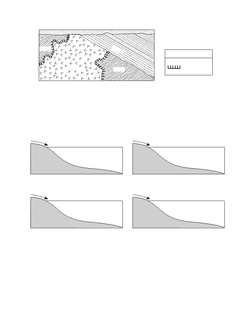
33 Which profile best shows the general depositional pattern that occurs when water from a stream enters the
ocean?
S t r e a m
S t r e a m
Ocean surface
Ocean surface
P
e
C
b b
l a
l e
y
s
C l a y
S i l t
S a n d
S a n d
P e b b l e s
Bedrock
S i l t
Bedrock
( 1 )
( 3 )
S t r e a m
S t r e a m
Ocean surface
Ocean surface
S
a
P
n d
e b b
l e
s
P e
b b l e s
S
C l a y
a n d
Bedrock
S i l t
S i l t
Bedrock
C l a y
( 2 )
( 4 )
P.S./E. Sci.–Jan. ’09
[8]
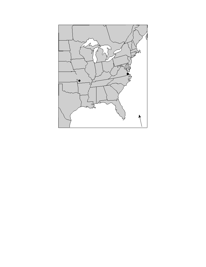
34 The map below shows the locations of Virginia Beach, Virginia, and Springfield, Missouri.
Virginia
Beach
Springfield
Atlantic
Ocean
N
Gulf of Mexico
Virginia Beach experiences cooler summers and warmer winters than Springfield
because Virginia Beach
(1) is located closer to the Atlantic Ocean
(2) is located closer to the equator
(3) has a greater average yearly duration of insolation
(4) has a greater average yearly intensity of insolation
P.S./E. Sci.–Jan. ’09
[9]
[OVER]
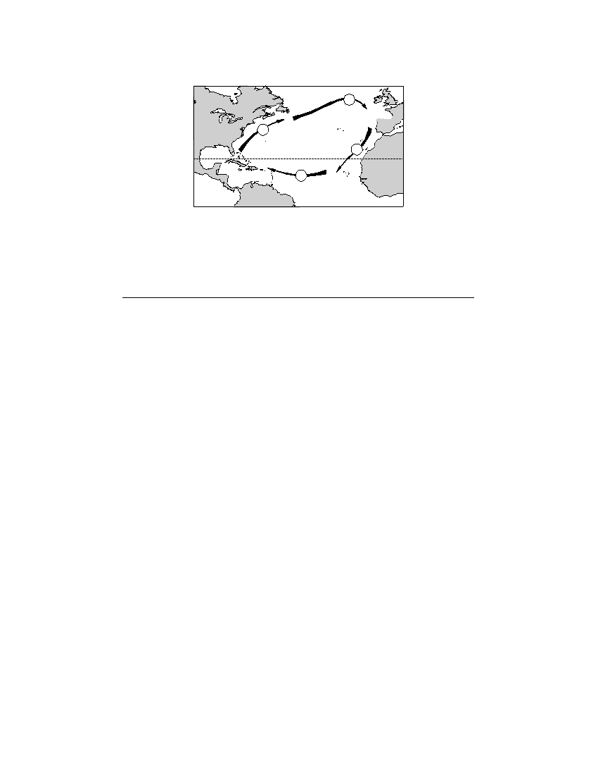
35 The arrows labeled A through D on the map below show the general paths of abandoned boats that have
floated across the Atlantic Ocean.
C
Europe
North
America
B
D
Tropic of Cancer
Africa
A
South
America
Which sequence of ocean currents was responsible for the movement of these boats?
(1) South Equatorial → Gulf Stream → Labrador → Benguela
(2) South Equatorial → Australia → West Wind Drift → Peru
(3) North Equatorial → Koroshio → North Pacific → California
(4) North Equatorial → Gulf Stream → North Atlantic → Canaries
P.S./E. Sci.–Jan. ’09
[10]

Part B–1
Answer all questions in this part.
Directions (36–50): For each statement or question, write on your separate answer sheet the number of the
word or expression that, of those given, best completes the statement or answers the question. Some questions
may require the use of the Earth Science Reference Tables .
Base your answers to questions 36 through 38 on the passage below.
Fossils and the History of Earth’s Rotation
Data from coral fossils support the hypothesis that Earth’s rotation rate has been
slowing down by about 2.5 seconds per 100,000 years. Scientists believe this is due to
the frictional effects of ocean tides. This slowing rotation rate decreases the number
of days in the year.
Scientists have discovered that corals produce a thin layer of shell every day, result-
ing in growth rings. These daily layers are separated by yearly ridges.
The Devonian coral fossil, Pleurodictyum , has approximately 400 growth rings
between each yearly ridge, which suggests that there were about 400 days in a year
during the Devonian Period.
Supporting this hypothesis, scientists have found coral from the Pennsylvanian
Period that have about 390 growth rings per year, while present-day corals have about
365 growth rings per year.
36 Approximately how many fewer Earth days per year are there today than there were
during the Devonian Period?
(1) 10
(3) 35
(2) 25
(4) 40
37 What inference can be made about the number of growth rings per year for a coral
from the Permian Period and Ordovician Period compared to the number of growth
rings per year for the Devonian coral, Pleurodictyum ?
(1) Ordovician coral would have fewer, but Permian coral would have more.
(2) Ordovician coral would have more, but Permian coral would have fewer.
(3) Both Ordovician and Permian coral would have fewer.
(4) Both Ordovician and Permian coral would have more.
38 The evidence of the fossil Pleurodictyum found in surface bedrock in the Finger
Lakes region of New York State suggests that this region was once
(1) covered by a glacial ice sheet
(3) located in a desert area
(2) covered by a warm, shallow sea
(4) located in a tropical rain forest
P.S./E. Sci.–Jan. ’09
[11]
[OVER]
Base your answers to questions 39 through 41 on the diagram below, which shows a model of Earth’s orbit
around the Sun. Letters A , B , C , and D represent Earth’s position at the beginning of each season.
D
A
Sun
C
B
(Not drawn to scale)
39 Which position of Earth represents the first day of summer in the Northern
Hemisphere?
(1) A
(3) C
(2) B
(4) D
40 The diagram below shows how Earth is illuminated [lighted] by the Sun as viewed
from above the North Pole.
E q u a t o r
T r o
p i c
o
c
C i r c l e
f
C
it
a
n
cr
c
A
North Pole
In which orbital position would Earth be illuminated as shown?
(1) A
(3) C
(2) B
(4) D
P.S./E. Sci.–Jan. ’09
[12]
41 How many degrees will the Sun’s vertical rays shift on Earth’s surface as Earth
travels from position C to position D ?
(1) 15°
(3) 47°
(2) 23.5°
(4) 365°
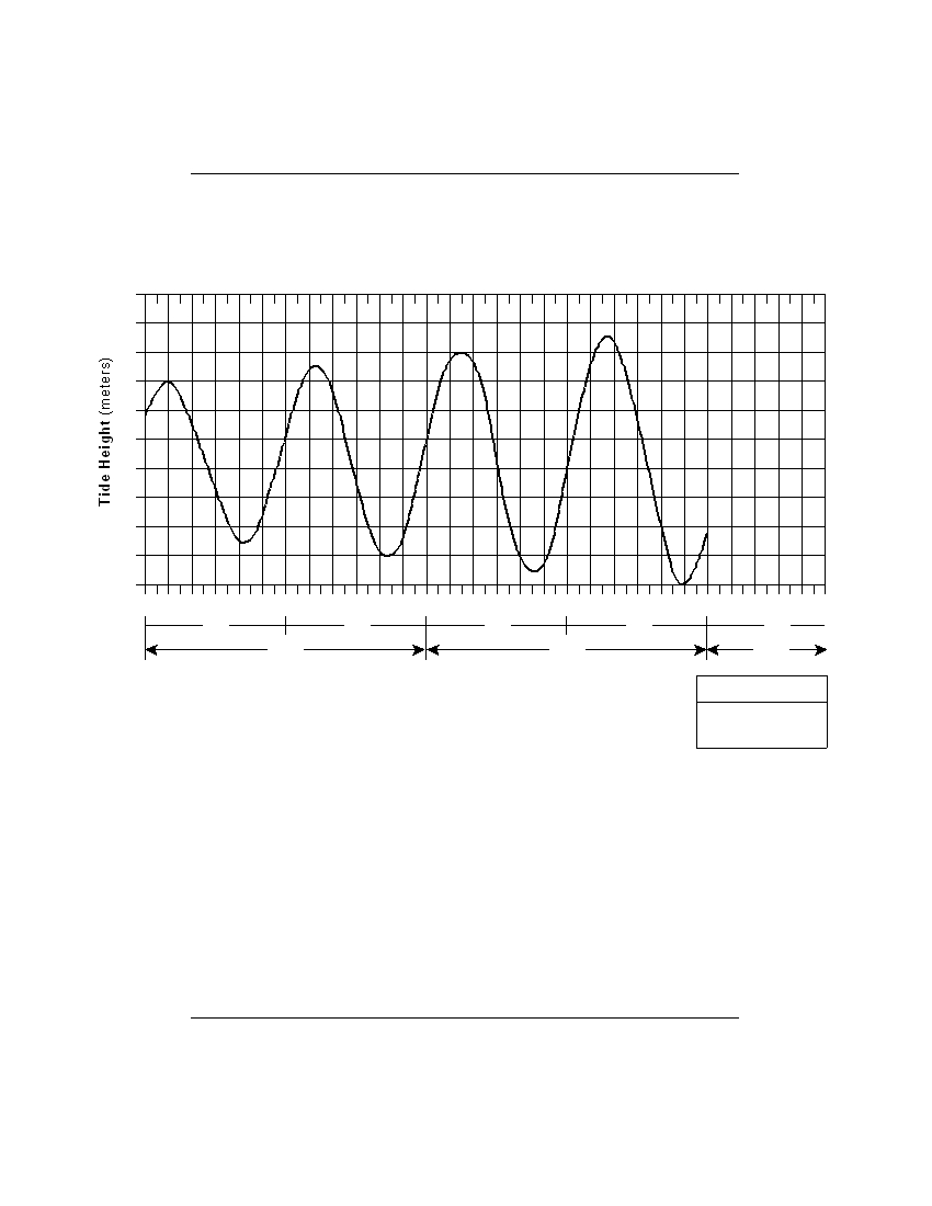
Base your answers to questions 42 and 43 on the graph below, which shows two days of tidal data from a
coastal location in the northeastern United States.
Tidal Changes
2.4
2.2
2.0
1.8
1.6
1.4
1.2
1.0
0.8
0.6
0.4
Mid 2
4
6
8 10
N
2
4
6
8 10 Mid 2
4
6
8 10
N
2
4
6
8 10 Mid 2
4
6
8 10
a.m.
p.m.
a.m.
p.m.
a.m.
Day 1
Day 2
Day 3
Key
Mid – Midnight
N – Noon
42 The change in the tides as shown on the graph is primarily the result of
(1) Earth’s rotation and the Moon’s revolution
(2) Earth’s rotation and revolution
(3) the Moon’s rotation and Earth’s revolution
(4) the Moon’s rotation and revolution
43 If the pattern shown continues, the most likely height and time for the first high tide
on day 3 would be
(1) 2.2 meters at 4 a.m.
(3) 2.2 meters at 5 a.m.
(2) 2.3 meters at 4 a.m.
(4) 2.3 meters at 5 a.m.
P.S./E. Sci.–Jan. ’09
[13]
[OVER]
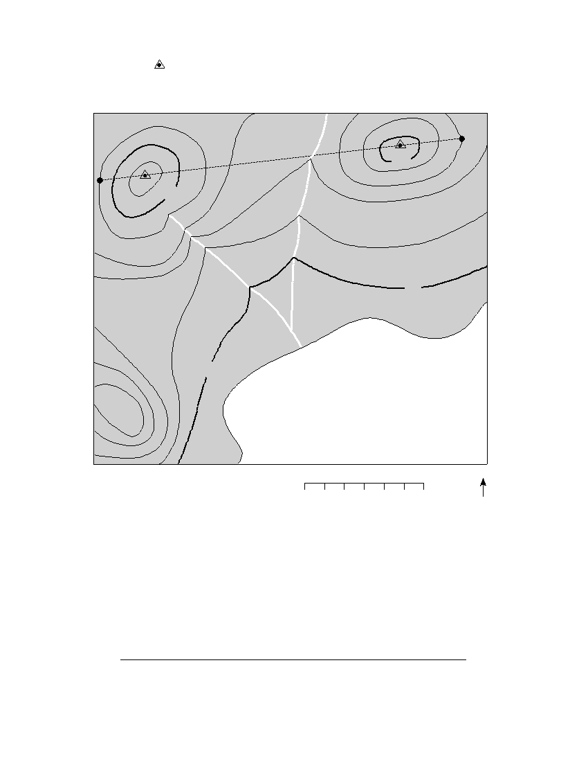
Base your answers to questions 44 through 46 on the map of the Mid-Atlantic Ridge shown below.
Points A through D are locations on the ocean floor. Line XY connects locations in North America and Africa.
North
Europe
America
X
Y
Africa
South
America
A B C
D
Mid-Atlantic
Ridge
44 In which cross section do the arrows best show the convection occurring within the
asthenosphere beneath line XY ?
X
Mid-Atlantic Ridge
Y
X
Mid-Atlantic Ridge
Y
Atlantic
Ocean
Atlantic
Ocean
Asthenosphere
Asthenosphere
( 1 )
( 3 )
X
Mid-Atlantic Ridge
Y
X
Mid-Atlantic Ridge
Y
Atlantic
Ocean
Atlantic
Ocean
Asthenosphere
Asthenosphere
( 2 )
( 4 )
45 Samples of ocean-floor bedrock were collected at points A , B , C , and D . Which
sequence shows the correct order of the age of the bedrock from oldest to youngest?
(1) D → C → B → A
(3) C → B → D → A
(2) A → D → B → C
(4) A → B → D → C
46 The boundary between which two tectonic plates is most similar geologically to the
plate boundary at the Mid-Atlantic Ridge?
(1) Eurasian and Indian-Australian
(3) Pacific and Nazca
(2) Cocos and Caribbean
(4) Nazca and South American
P.S./E. Sci.–Jan. ’09
[14]
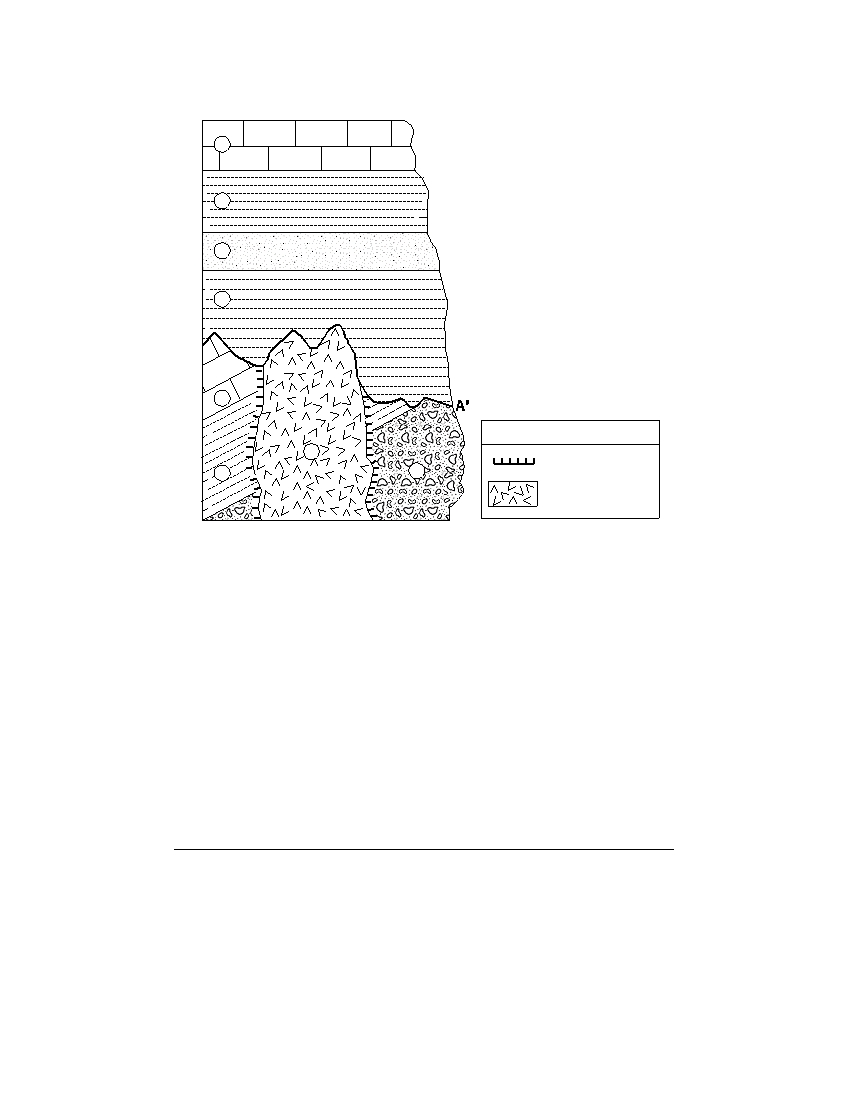
Base your answers to questions 47 through 49 on the cross section below. Rock units are labeled 1 through 8.
The line between A and A ′ indicates an unconformity.
1
2
3
4
A
5
Key
7
Contact
6
8
metamorphism
Granite intrusion
47 Which characteristic of the granite intrusion provides the most evidence that it
solidified deep underground?
(1) very hard
(3) light color
(2) coarse texture
(4) felsic composition
48 Which event occurred sometime after the formation of the unconformity?
(1) formation of rock unit 3
(2) tilting of rock unit 5
(3) deposition of the sediments that formed rock unit 8
(4) intrusion of rock unit 7
49 Which rock most probably formed in the contact metamorphic zone within rock unit 6?
(1) marble
(3) quartzite
(2) basalt
(4) hornfels
P.S./E. Sci.–Jan. ’09
[15]
[OVER]
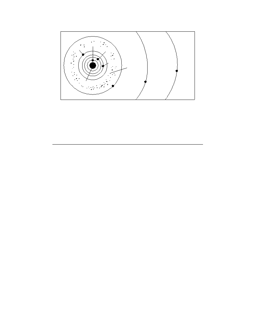
Base your answer to question 50 on the diagram below. This diagram shows a portion of the solar system.
Mercury
Mars
Venus
Earth
Asteroid
belt
Uranus
Sun
Saturn
Jupiter
(Not drawn to scale)
50 What is the average distance, in millions of kilometers, from the Sun to the asteriod
belt?
(1) 129
(3) 503
(2) 189
(4) 857
P.S./E. Sci.–Jan. ’09
[16]

Part B–2
Answer all questions in this part.
Directions (51–65): Record your answers in the spaces provided in your answer booklet. Some questions
may require the use of the Earth Science Reference Tables.
Base your answers to questions 51 and 52 on the diagram in your answer booklet, which represents the sky
above an observer in Elmira, New York. Angular distances above the horizon are indicated. The Sun’s
apparent path for December 21 is shown.
51 On March 21, the altitude of the noon Sun in Elmira is 48°. On the diagram in your
answer booklet , draw the Sun’s apparent path for March 21, as it would appear to the
observer. Be sure your path begins and ends at the correct positions on the horizon
and indicates the correct altitude of the noon Sun. [1]
52 On what date of the year does the maximum duration of insolation usually occur at
Elmira? [1]
Base your answers to questions 53 through 57 on the weather map in your answer booklet, which shows two
fronts associated with a low-pressure system.
53 On the weather map in your answer booklet , write the letter L at the location of the
center of the low-pressure system. [1]
54 On the weather map in your answer booklet , write the air-mass symbols to indicate
the most likely locations of the continental polar air mass and maritime tropical air
mass that have formed this low-pressure system. [1]
55 On the weather map in your answer booklet , place an X where precipitation is most
likely occurring. [1]
56 Which type of weather front has entered New York State? [1]
57 Warm, moist air is rising along the two frontal surfaces. Describe how the water vapor
in this rising air forms clouds. Include dewpoint and condensation in your answer. [1]
P.S./E. Sci.–Jan. ’09
[17]
[OVER]
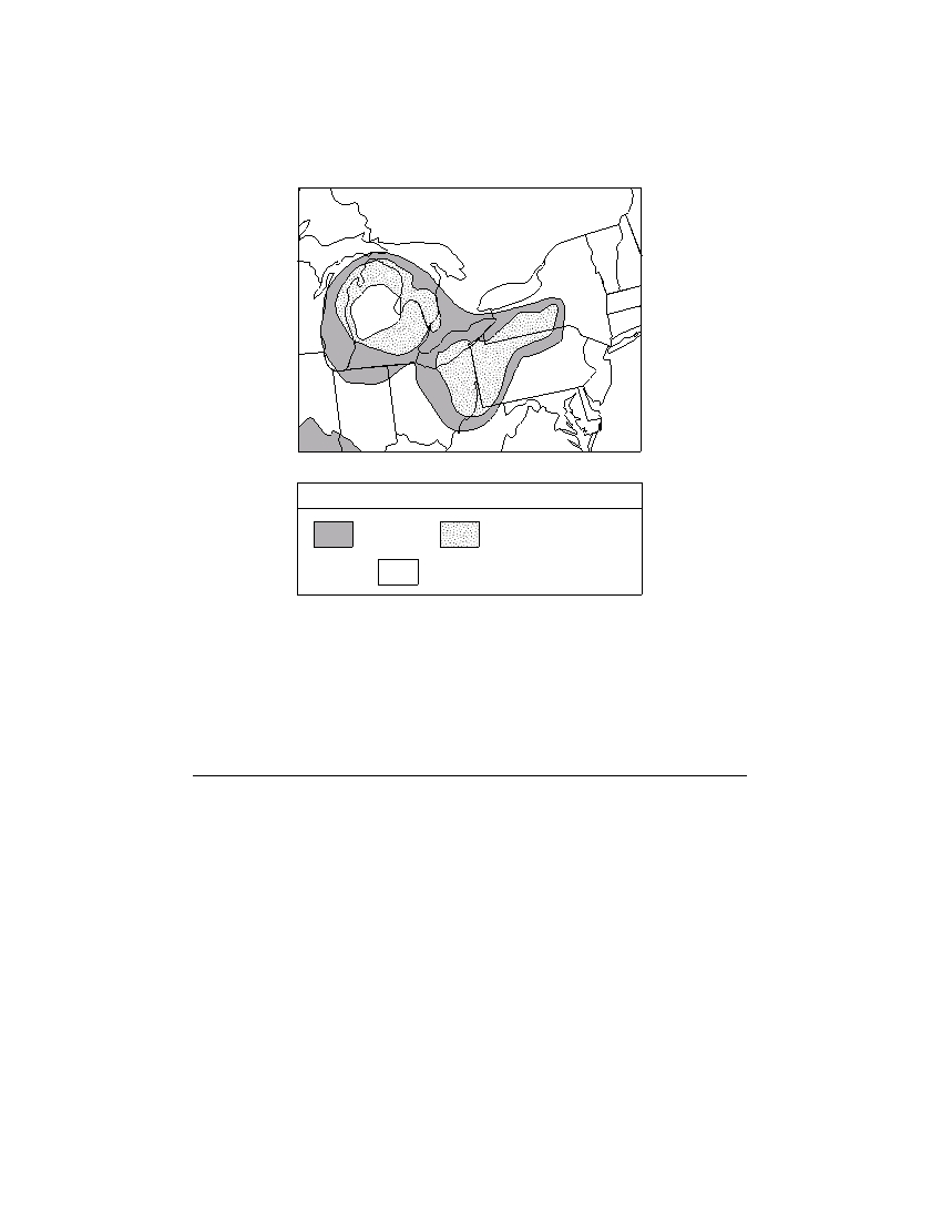
Base your answers to questions 58 and 59 on the map below. The map shows the approximate area in a
portion of North America where some sedimentary rock layers composed of gypsum, halite, and potassium salt
minerals are found in Earth’s crust.
Mineral Deposits
Key
Gypsum
Gypsum and halite
Gypsum, halite,
and potassium salts
58 Identify one New York State landscape region in which deposits of gypsum and halite
are commonly found. [1]
59 Identify the sedimentary rock composed of halite and explain how this rock is
usually formed. [1]
P.S./E. Sci.–Jan. ’09
[18]
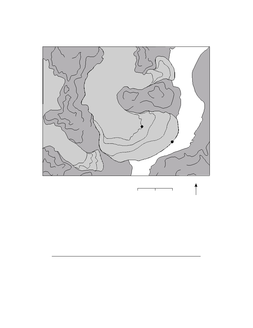
Base your answers to questions 60 through 62 on the topographic map below, which shows three glaciers
found in Alaska. Dashed lines show the inferred location of the front edge of each glacier in 1948, 1964, and
1980. Solid lines show the location of the front edge of each glacier in 1998. Points A and B show the location
of the front edge of the Taku Glacier in 1948 and 1998. Elevations are in feet.
3000
1000
8
2000
0
9
8
9
9
1
8
1
4
Hole-in-the-Wall
9
1 1964
Glacier
2000
2000
1000
Taku
River
3000
Taku Glacier
2000
A
1000
1948
1964
B
Norris
1980
Glacier
8
1998
4
1998
9
1
1980
1964
2000
3000 2000
1000
N
0
1
2 miles
60 Determine the rate, in miles per year, that the front edge of the Taku Glacier moved
between point A and point B . [1]
61 What is the contour interval on this map? [1]
62 If these glaciers completely melted, what two pieces of evidence would a scientist
most likely find to indicate that glaciers had existed in this area? [1]
P.S./E. Sci.–Jan. ’09
[19]
[OVER]
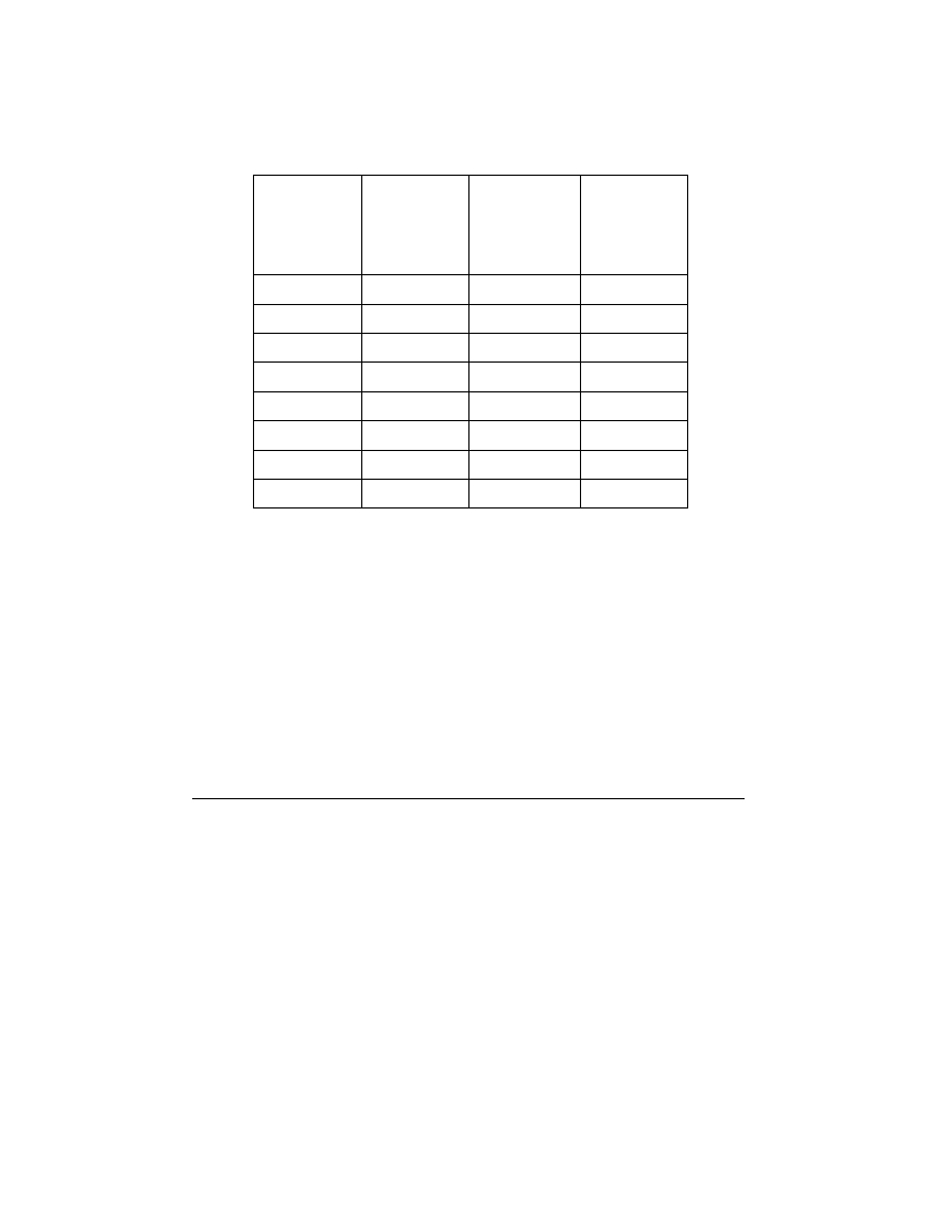
Base your answers to questions 63 through 65 on the data table below, which shows the average distance
from the Sun, the average surface temperature, and the average orbital velocity for each planet in our solar
system.
Data Table
Average
Distance
Average
Average
Planet
from Sun
Surface
Orbital
(millions
Temperature
Velocity
of km)
(°C)
(km/sec)
Mercury
58
167
47.9
Venus
108
457
35.0
Earth
150
14
29.8
Mars
228
–55
24.1
Jupiter
778
–153
13.1
Saturn
1427
–185
9.7
Uranus
2869
–214
6.8
Neptune
4496
–225
5.4
63 State the relationship between the average distance from the Sun and the average
surface temperature of the Jovian planets. [1]
64 Venus has an atmosphere composed mostly of carbon dioxide. Mercury has almost
no atmosphere.
Explain how the presence of the carbon dioxide in Venus’
atmosphere causes the average surface temperature on Venus to be higher than the
average surface temperature on Mercury. [1]
65 On the graph in your answer booklet , draw a line to indicate the general relationship
between a planet’s average distance from the Sun and its average orbital velocity. [1]
P.S./E. Sci.–Jan. ’09
[20]

Part C
Answer all questions in this part.
Directions (66–84): Record your answers in the spaces provided in your answer booklet. Some questions
may require the use of the Earth Science Reference Tables .
Base your answers to questions 66 through 70 on the passage below and on the map in your answer booklet.
The passage describes the New Madrid fault system. The numbers on the map show the predicted relative
damage at various locations if a large earthquake occurs along the New Madrid fault system. The higher the
number, the greater the relative damage.
The New Madrid Fault System
The greatest earthquake risk area east of the Rocky Mountains is along the New
Madrid fault system. The New Madrid fault system consists of a series of faults along
a weak zone in the continental crust in the midwestern United States. Earthquakes
occur in the Midwest less often than in California, but when they do happen, the
damage is spread over a wider area due to the underlying bedrock.
In 1811 and 1812, the New Madrid fault system experienced three major
earthquakes. Large land areas sank, new lakes formed, the course of the Mississippi
River changed, and 150,000 acres of forests were destroyed.
66 On the map in your answer booklet , draw the 4, 6, and 8 isolines indicating relative
damage. [1]
67 Using the predicted damage numbers, place an X on the map to indicate where the
New Madrid fault system most likely exists. [1]
68 The distance between the New Madrid fault system and Albany, New York, is
1800 kilometers. What was the time difference between the arrival of the first
P -wave and the arrival of the first S -wave at Albany when the 1812 earthquake
occurred? [1]
69 State one reason why earthquakes occur more frequently on the western coast of the
United States than in the New Madrid region. [1]
70 An emergency management specialist near the New Madrid region is developing a
plan that would help save lives and prevent property damage in the event of an
earthquake. Describe two actions that should be included in the plan. [1]
P.S./E. Sci.–Jan. ’09
[21]
[OVER]
Base your answers to questions 71 through 74 on the data table below and on the graph in your answer
booklet. The data table shows the maximum altitude and phase of the Moon observed above the southern
horizon on certain dates during January and February at a New York State location. The line on the graph in
your answer booklet shows the altitude of the noontime Sun observed during the same time period at the same
New York State location.
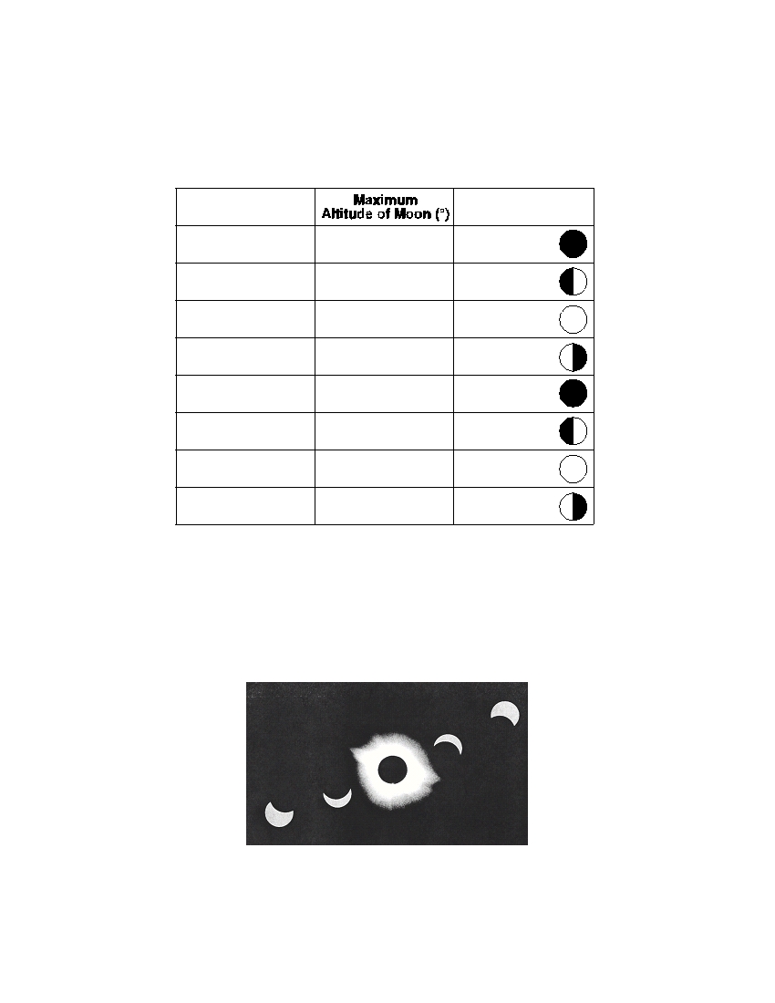
Data Table
Date
Phase of Moon
January 4
26
new
January 13
63
first quarter
January 19
72
full
January 26
35
last quarter
February 3
34
new
February 11
70
first quarter
February 18
60
full
February 25
27
last quarter
71 On the grid in your answer booklet , plot with an X the maximum altitude of the Moon
for each date shown on the data table. [1]
72 The multiple-exposure photograph below, taken on February 3, shows a total solar
eclipse in the middle of the photograph. The maximum altitude of the Sun on this
date was 34° above the southern horizon at this New York State location.
Based on the data table, explain why this total solar eclipse occurred on February 3. [1]
P.S./E. Sci.–Jan. ’09
[22]

73 The diagram in your answer booklet shows the Moon’s orbit around Earth. Place
an X on the orbit to represent the Moon’s position on February 18. [1]
74 Assuming that February had 28 days, on which date in March did the next full Moon
occur? [1]
Base your answers to questions 75 and 76 on the diagram below of a mineral classification scheme that shows
the properties of certain minerals. Letters A through G represent mineral property zones. Zone E represents
the presence of all three properties. For example, a mineral that is harder than glass, has a metallic luster, but
does not have cleavage, would be placed in zone B . Assume that glass has a hardness of 5.5.
g l a s s
h
a
n
M
e
a
r
d
e
r
t
t a
l l
ci
A
B
u
C
e
E
r
D
F
G
C l e a v a g e
75 In which zone would the mineral potassium feldspar be placed? [1]
76 State the name of one mineral listed on the Properties of Common Minerals Table that
could not be placed in any of the zones. [1]
P.S./E. Sci.–Jan. ’09
[23]
[OVER]
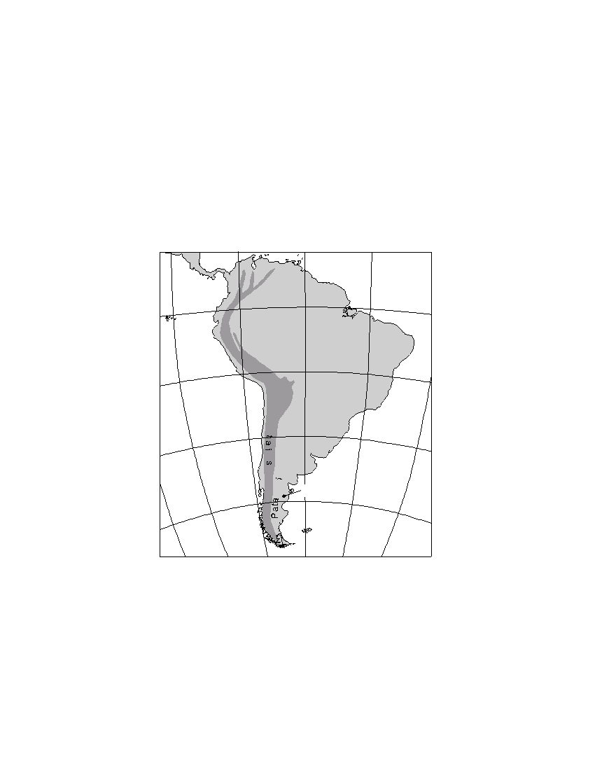
Base your answers to questions 77 through 81 on the passage and map below. Point F on the map shows the
location where an unusual mammal fossil was found.
Fossil Jaw of Mammal Found in South America
Paleontologists working in Patagonia have found the tiny fossil jaw that may be the
first evidence of early mammals in South America.
The fossil, which measures less than a quarter-inch long, is believed to be from the
middle or late Jurassic Period. Researchers said it suggests that mammals developed
independently in the Southern Hemisphere.
The fossil, named Asfaltomylos patagonicus , was discovered in a shale formation in
Patagonia. Dinosaurs were the dominant land animal at that time. Mammals were tiny,
and hunted insects in the dense tropical vegetation. The now-arid region also has yielded
some remarkable dinosaur fossils from the same period in a vast ancient boneyard
covering hundreds of square miles.
90 ° W
75 ° W
60 ° W
45 ° W
0 °
0 °
A
n
S o u t h A m e r i c a
d
e
s
15 ° S
15 ° S
M
o
u
n
n
30 ° S
30 ° S
a
g
o
n
F
45 ° S
45 ° S
105 ° W
90 ° W
75 ° W
60 ° W
45 ° W
30 ° W
77 State the latitude and longitude of point F , to the nearest degree , where the fossil
Asfaltomylos patagonicus was discovered. Include the correct units and compass
directions in your answer. [1]
78 State the name of the dominant sediment particle that was compacted to form the
shale in which this fossil was found. [1]
P.S./E. Sci.–Jan. ’09
[24]

79 What other life-form first appeared on Earth during the geologic period when
Asfaltomylos patagonicus existed? [1]
80 State one method used by geologists to determine the age of the bedrock in which
this ancient mammal fossil was found. [1]
81 Explain how the uplift of the Andes Mountains changed eastern Patagonia’s climate
from a wet tropical forest at the time Asfaltomylos patagonicus lived to the arid
conditions of today. [1]
P.S./E. Sci.–Jan. ’09
[25]
[OVER]
Base your answers to questions 82 through 84 on the topographic map below. Points A and B are reference
points on the map. The
symbols show the highest elevations on Eagle Hill and Timony Hill. Elevations are
shown in feet.
Topographic Map
o n y H i l l
T i m
B
H i
712
E
a
g l e l l
700
A
730
River
700
Blue
Auroro
Creek
600
600
Patriot
Lake Muhl
Hill
N
Contour interval = 20 feet
0
2
4
6 miles
82 Identify the general compass direction toward which Auroro Creek is flowing. [1]
83 State a possible elevation of the top of Patriot Hill. [1]
84 On the grid in your answer booklet , construct a topographic profile along line AB by
plotting an X for the elevation of each contour line that crosses line AB . Connect the
plotted X s with a smooth, curved line to complete the profile. Points A and B have
been plotted. [2]
P.S./E. Sci.–Jan. ’09
[26]

The University of the State of New York
R EGENTS H IGH S CHOOL E XAMINATION
PHYSICAL SETTING
EARTH SCIENCE
Wednesday, January 28, 2009 — 9:15 a.m. to 12:15 p.m., only
ANSWER SHEET
Student . . . . . . . . . . . . . . . . . . . . . . . . . . . . . . . . . . . . . . . . . . . . . . .
Sex:
I Male I Female Grade . . . . . . . . . . . .
Teacher . . . . . . . . . . . . . . . . . . . . . . . . . . . . . . . . . . . . . . . . . . . . . . .
School . . . . . . . . . . . . . . . . . . . . . . . . . . . . . . . . . . . .
Record your answers to Part A and Part B–1 on this answer sheet.
Part A
Part B–1
1 . . . . . . . . . . . .
13 . . . . . . . . . . . .
25 . . . . . . . . . . .
36 . . . . . . . . . . . .
44 . . . . . . . . . . . .
2 . . . . . . . . . . . .
14 . . . . . . . . . . . .
26 . . . . . . . . . . .
37 . . . . . . . . . . . .
45 . . . . . . . . . . . .
3 . . . . . . . . . . . .
15 . . . . . . . . . . . .
27 . . . . . . . . . . .
38 . . . . . . . . . . . .
46 . . . . . . . . . . . .
4 . . . . . . . . . . . .
16 . . . . . . . . . . . .
28 . . . . . . . . . . .
39 . . . . . . . . . . . .
47 . . . . . . . . . . . .
5 . . . . . . . . . . . .
17 . . . . . . . . . . . .
29 . . . . . . . . . . .
40 . . . . . . . . . . . .
48 . . . . . . . . . . . .
6 . . . . . . . . . . . .
18 . . . . . . . . . . . .
30 . . . . . . . . . . .
41 . . . . . . . . . . . .
49 . . . . . . . . . . . .
7 . . . . . . . . . . . .
19 . . . . . . . . . . . .
31 . . . . . . . . . . .
42 . . . . . . . . . . . .
50 . . . . . . . . . . . .
Part B–1 Score
8 . . . . . . . . . . . .
20 . . . . . . . . . . . .
32 . . . . . . . . . . .
43 . . . . . . . . . . . .
9 . . . . . . . . . . . .
21 . . . . . . . . . . . .
33 . . . . . . . . . . .
10 . . . . . . . . . . . .
22 . . . . . . . . . . . .
34 . . . . . . . . . . .
11 . . . . . . . . . . . .
23 . . . . . . . . . . . .
35 . . . . . . . . . . .
Part A Score
12 . . . . . . . . . . . .
24 . . . . . . . . . . . .
Write your answers to Part B–2 and Part C in your answer booklet.
The declaration below must be signed when you have completed the examination.
I do hereby affirm, at the close of this examination, that I had no unlawful knowledge of the questions or answers prior to
the examination and that I have neither given nor received assistance in answering any of the questions during the examination.
Signature

PS/EARTH SCIENCE
E C N E I C S H T R A E / S P