
PS/EARTH SCIENCE
The University of the State of New York
REGENTS HIGH SCHOOL EXAMINATION
PHYSICAL SETTING
EARTH SCIENCE
Wednesday, January 25, 2006 — 9:15 a.m. to 12:15 p.m., only
This is a test of your knowledge of Earth science. Use that knowledge to answer
all questions in this examination. Some questions may require the use of the Earth
Science Reference Tables. The Earth Science Reference Tables are supplied separately.
Be certain you have a copy of the 2001 edition of these reference tables before you
begin the examination.
Your answer sheet for Part A and Part B–1 is the last page of this examination
booklet. Turn to the last page and fold it along the perforations. Then, slowly and
carefully, tear off your answer sheet and fill in the heading.
The answers to the questions in Part B–2 and Part C are to be written in your
separate answer booklet. Be sure to fill in the heading on the front of your answer
booklet.
You are to answer all questions in all parts of this examination according to the
directions provided in the examination booklet. Record your answers to the Part A
and Part B–1 multiple-choice questions on your separate answer sheet. Write your
answers to the Part B–2 and Part C questions in your answer booklet. All work should
be written in pen, except for graphs and drawings, which should be done in pencil.
You may use scrap paper to work out the answers to the questions, but be sure to
record all your answers on your separate answer sheet and in your answer booklet.
When you have completed the examination, you must sign the statement printed
at the end of your separate answer sheet, indicating that you had no unlawful
knowledge of the questions or answers prior to the examination and that you have
neither given nor received assistance in answering any of the questions during the
examination. Your answer sheet and answer booklet cannot be accepted if you fail to
sign this declaration.
Notice. . .
A four-function or scientific calculator and a copy of the 2001 Earth Science Reference Tables
must be available for you to use while taking this examination.
The use of any communications device is strictly prohibited when taking this
examination. If you use any communications device, no matter how briefly, your
examination will be invalidated and no score will be calculated for you.
DO NOT OPEN THIS EXAMINATION BOOKLET UNTIL THE SIGNAL IS GIVEN.
E C N E I C S H T R A E / S P
Part A
Answer all questions in this part.
Directions (1–35): For each statement or question, write on your separate answer sheet the number of the
word or expression that, of those given, best completes the statement or answers the question. Some questions
may require the use of the Earth Science Reference Tables .
1 Which event takes the most time?
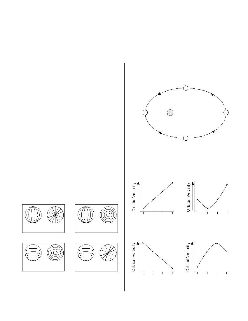
5 The diagram below shows a satellite in four
(1) one revolution of Earth around the Sun
different positions as it revolves around a planet.
(2) one revolution of Venus around the Sun
(3) one rotation of the Moon on its axis
C
(4) one rotation of Venus on its axis
2 Compared to the Jovian planets in our solar
system, Earth is
(1) less dense and closer to the Sun
D
Satellite
Planet
B
(2) less dense and farther from the Sun
(3) more dense and closer to the Sun
(4) more dense and farther from the Sun
3 A Foucault pendulum appears to change its
A
direction of swing due to the
(Not drawn to scale)
(1) tilt of Earth’s axis
(2) spin of Earth on its axis
Which graph best represents the changes in this
(3) deflection of Earth’s planetary winds
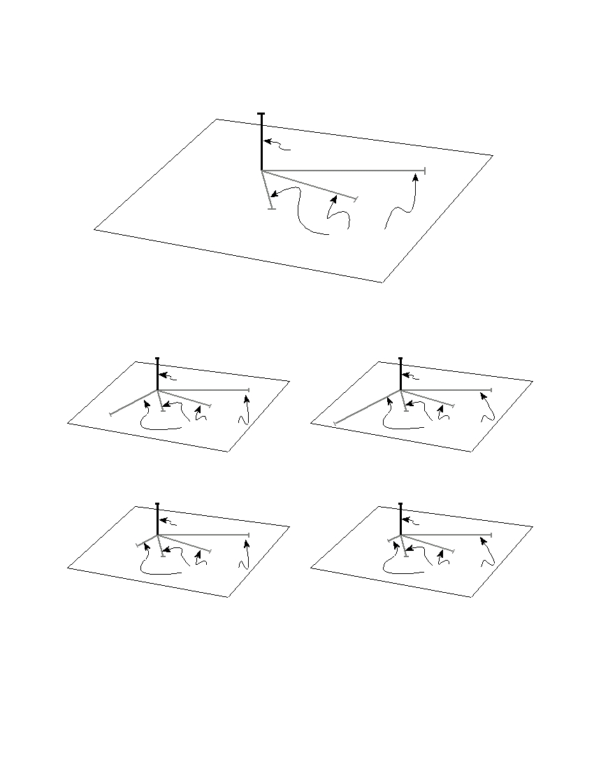
satellite’s orbital velocity as it revolves around the
(4) movement of Earth in its orbit around the
planet?
Sun
4 The lines on which set of views best represent
Earth’s latitude system?
A
B
C
D
A
B
C
D
Satellite Position
Satellite Position
Equatorial
Polar
Equatorial
Polar
view
view
view
view
( 1 )
( 3 )
( 1 )
( 3 )
Equatorial
Polar
Equatorial
Polar
view
view
view
view
( 2 )
( 4 )
A
B
C
D
A
B
C
D
Satellite Position
Satellite Position
( 2 )
( 4 )
P.S./E. Sci.–Jan. ’06
[2]

6 At which New York State location will an observer
12 Most New York State sandstone bedrock was
most likely measure the altitude of Polaris as
formed
approximately 42°?
(1) in Earth’s interior where temperatures
(1) Jamestown
(3) Oswego
exceeded the melting point of quartz
(2) Plattsburgh
(4) New York City
(2) on Earth’s surface from the cooling of molten
lava
(3) in a delta from sand grains deposited, buried,
7 Which statement provides evidence that Earth
and cemented together by minerals
revolves around the Sun?
(4) in a desert when heat and metamorphic pres-
(1) Winds at different latitudes are curved differ-
sure caused quartz crystals to fuse together
ent amounts by the Coriolis effect.
(2) Different star constellations are visible from
Earth at different seasons of the year.
13 Which statement best explains why no Permian-
(3) The Sun follows an apparent arc across the
age bedrock is found in New York State?
sky during the day.
(1) The extinction of many life-forms occurred at
(4) The stars appear to circle Earth during the
the end of the Permian Period.
night.
(2) Only rocks of igneous origin formed in New
York State during the Permian Period.
(3) Permian-age rocks have been metamor-
8 Compared to the surface temperature and lumi-
phosed and cannot be identified.
nosity of massive stars in the Main Sequence, the
(4) Permian-age rocks were either eroded away
smaller stars in the Main Sequence are
or never formed in New York State.
(1) hotter and less luminous
(2) hotter and more luminous
(3) cooler and less luminous
14 A fossil shell contains 25% of the original amount
(4) cooler and more luminous
of its carbon-14. Approximately how many years
ago was this shell part of a living organism?
(1) 5,700 years ago
(3) 17,100 years ago
9 Which factor most likely causes two cities at the
(2) 11,400 years ago
(4) 22,800 years ago
same elevation and latitude to have different
yearly average temperature ranges?
(1) rotation of Earth
15 Which sequence shows the correct order of
(2) duration of insolation
Earth’s geologic time intervals from oldest to
(3) distance from a large body of water
youngest?
(4) direction of prevailing winds
(1) Archean → Mesozoic → Cenozoic →
Paleozoic → Proterozoic
(2) Archean → Proterozoic → Paleozoic →
10 Which set of surface soil conditions on a hillside
Mesozoic → Cenozoic
would result in the most infiltration of rainfall?
(3) Cenozoic → Mesozoic → Paleozoic →
(1) gentle slope, saturated soil, no vegetation
Proterozoic → Archean
(2) gentle slope, unsaturated soil, vegetation
(4) Cenozoic → Paleozoic → Archean →
(3) steep slope, saturated soil, vegetation
Mesozoic → Proterozoic
(4) steep slope, unsaturated soil, no vegetation
16 In which direction do the surface winds blow
11 Scientists have inferred that Earth’s original
around a high-pressure system in the Northern
atmosphere was formed by the
Hemisphere?
(1) outgassing from Earth’s interior
(1) clockwise and inward
(2) erosion of Earth’s surface
(2) clockwise and outward
(3) decay of microorganisms in Earth’s oceans
(3) counterclockwise and inward
(4) radioactive decay of elements in Earth’s core
(4) counterclockwise and outward
P.S./E. Sci.–Jan. ’06
[3]
[OVER]
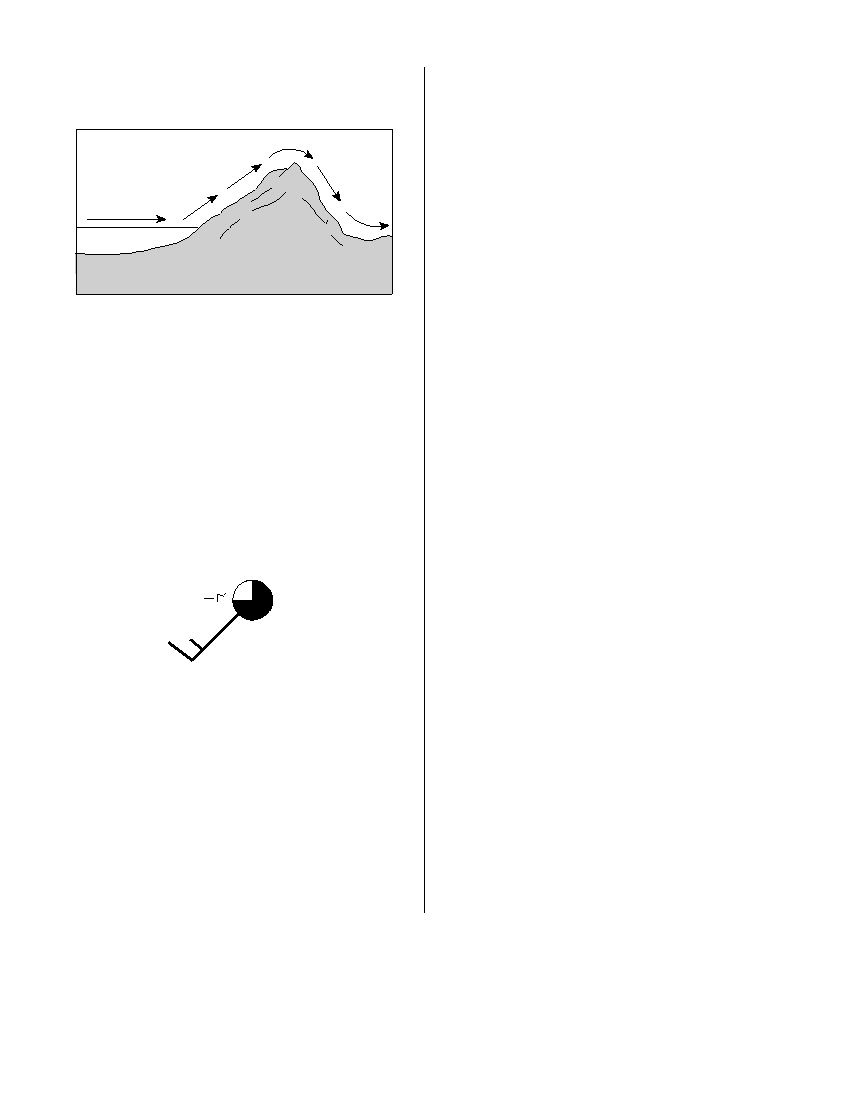
17 The cross section below shows the flow of winds
19 The properties of an air mass are mostly deter-
over a mountain ridge.
mined by the
(1) rate of Earth’s rotation
(2) direction of Earth’s surface winds
Windward
Leeward
(3) source region where the air mass formed
side
side
(4) path the air mass follows along a land surface
Wind
20 Which list correctly matches each instrument
Mountain
Ocean
with the weather variable it measures?
(1) wind vane—wind speed
thermometer—temperature
precipitation gauge—relative humidity
The heaviest rainfall would most likely occur on
(2) wind vane—wind direction
which side of this mountain and in which type of
thermometer—dewpoint
air mass?
psychrometer—air pressure
(1) on the leeward side, in a mP air mass
(3) barometer—relative humidity
(2) on the leeward side, in a cT air mass
anemometer—cloud cover
(3) on the windward side, in a mT air mass
precipitation gauge—probability of
(4) on the windward side, in a cP air mass
precipitation
(4) barometer—air pressure
18 Various weather conditions at LaGuardia Airport
anemometer—wind speed
in New York City are shown on the station model
psychrometer—relative humidity
below.
21 What is the difference between the dry-bulb
temperature and the wet-bulb temperature when
43
146
3
the relative humidity is 28% and the dry-bulb
4
temperature is 0°C?
40
.06
(1) 11°C
(3) 28°C
(2) 2°C
(4) 4°C
What were the barometric pressure and weather
22 Based on the theory of plate tectonics, it is
conditions at the airport at the time of the obser-
inferred that over the past 250 million years
vation?
North America has moved toward the
(1) 914.6 mb of pressure and smog
(1) northwest
(3) southeast
(2) 914.6 mb of pressure and a clear sky
(2) southwest
(4) northeast
(3) 1014.6 mb of pressure and smog
(4) 1014.6 mb of pressure and a clear sky
23 According to tectonic plate maps, New York State
is presently located
(1) at a convergent plate boundary
(2) above a mantle hot spot
(3) above a mid-ocean ridge
(4) near the center of a large plate
P.S./E. Sci.–Jan. ’06
[4]
Base your answers to questions 24 and 25 on the cross-sectional view of Earth below, which shows seismic
waves traveling from the focus of an earthquake. Points A and B are locations on Earth’s surface.
Earthquake focus
P- and S-waves
P- and S-waves
received here
received here
A
Outer core
Inner
Core
Shadow zone
Shadow zone
No waves received
No waves received
B
Only one type of
wave received here
24 Which statement best explains why only one type
25 A seismic station located at point A is 5400 kilo-
of seismic wave was recorded at location B ?
meters away from the epicenter of the earth-
(1) S -waves cannot travel through the liquid
quake. If the arrival time for the P -wave at
outer core.
point A was 2:00 p.m., the arrival time for the
(2) S -waves cannot travel through the liquid
S -wave at point A was approximately
inner core.
(1) 1:53 p.m.
(3) 2:09 p.m.
(3) P -waves cannot travel through the solid outer
(2) 2:07 p.m.
(4) 2:16 p.m.
core.
(4) P -waves cannot travel through the solid inner
core.
P.S./E. Sci.–Jan. ’06
[5]
[OVER]
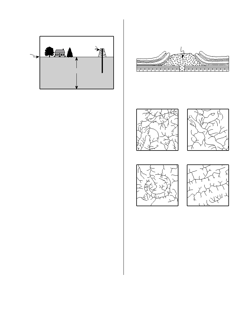
26 The cross section below shows a drill rig used to
30 The cross section below shows the rock structure
collect rock samples from below Earth’s surface.
of a deeply eroded, domed mountain region.
Igneous
Drill rig
intrusion
Earth’s
surface
2 kilometers
(Not drawn to scale)
Which map shows the stream drainage pattern
(Not drawn to scale)
that will most likely develop as the bedrock is
weathered and eroded from this igneous dome?
The rock samples collected from the bottom of
the drill hole came from which Earth layer?
(1) lithosphere
(3) asthenosphere
(2) hydrosphere
(4) stiffer mantle
27 Which sequence shows the order in which land-
scape regions are crossed as an airplane flies in a
straight course from Albany, New York, to
Massena, New York?
( 1 )
( 3 )
(1) plateau → plain → mountain
(2) plateau → mountain → plain
(3) plain → mountain → plain
(4) mountain → plain → plateau
28 Why are Precambrian gneiss cobbles and boulders
commonly found on top of the surface bedrock in
the Catskills?
(1) The surface bedrock of the Catskills is com-
posed of Precambrian gneiss.
( 2 )
( 4 )
(2) The surface bedrock of the Catskills has been
overturned.
(3) Many meteorites composed of gneiss have
landed in the Catskills.
(4) Glaciers transported these rocks from the
Adirondacks to the Catskills.
29 Which component of Earth’s atmosphere is
classified as a greenhouse gas?
(1) oxygen
(3) helium
(2) carbon dioxide
(4) hydrogen
P.S./E. Sci.–Jan. ’06
[6]
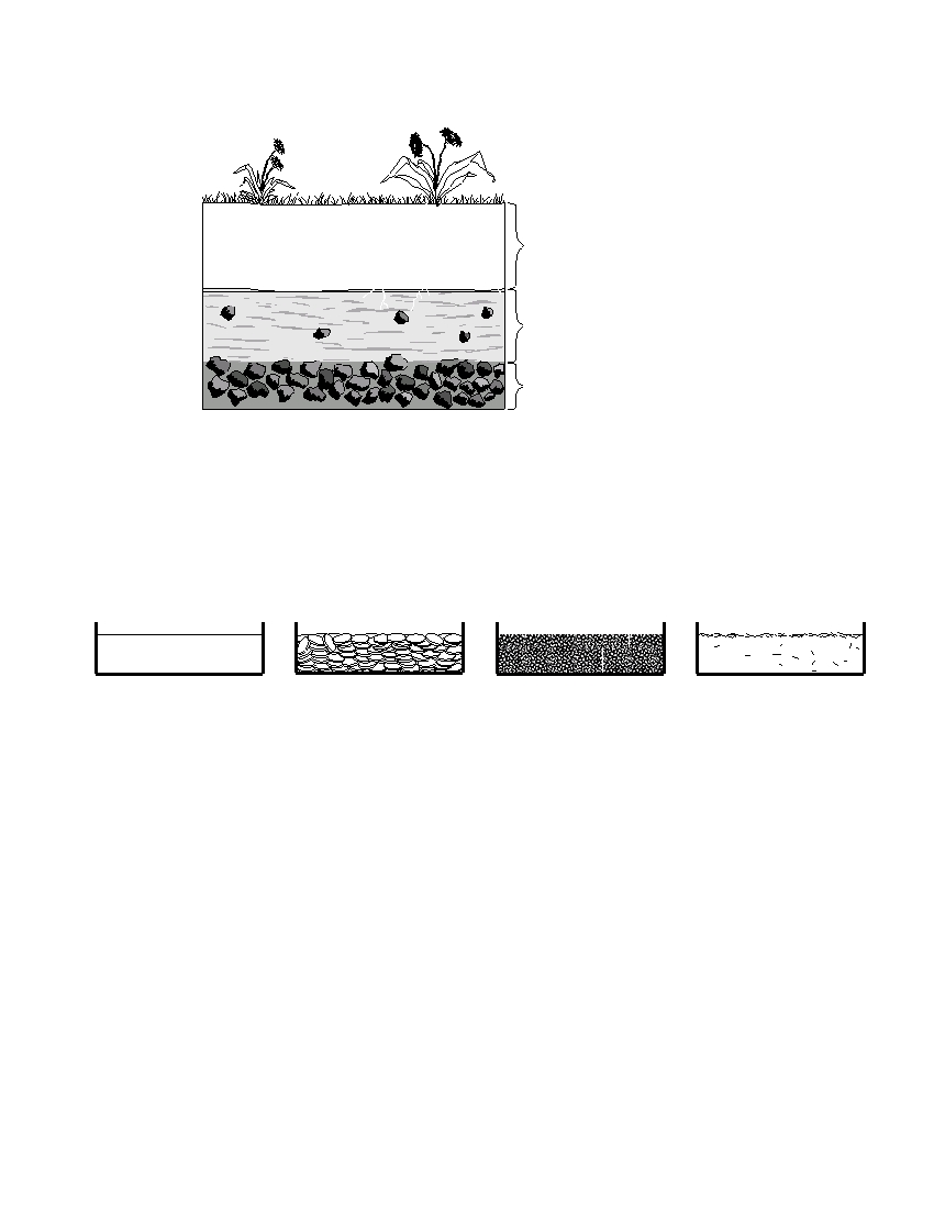
31 The cross section below shows layers of soil.
Dark brown to black soil
with a high organic content
Tan to orange soil with
a high clay content,
some rock fragments
Light gray to black soil,
coarse rock fragments
Which two processes produced the layer of dark brown to black soil?
(1) melting and solidification of magma
(3) weathering and biologic activity
(2) erosion and uplifting
(4) compaction and cementation
32 Equal volumes of the four samples shown below were placed outside and heated by energy from the Sun’s
rays for 30 minutes.
Water
Copper pennies
Basaltic sand
Iron fragments
The surface temperature of which sample increased at the slowest rate?
(1) water
(3) basaltic sand
(2) copper pennies
(4) iron fragments
P.S./E. Sci.–Jan. ’06
[7]
[OVER]
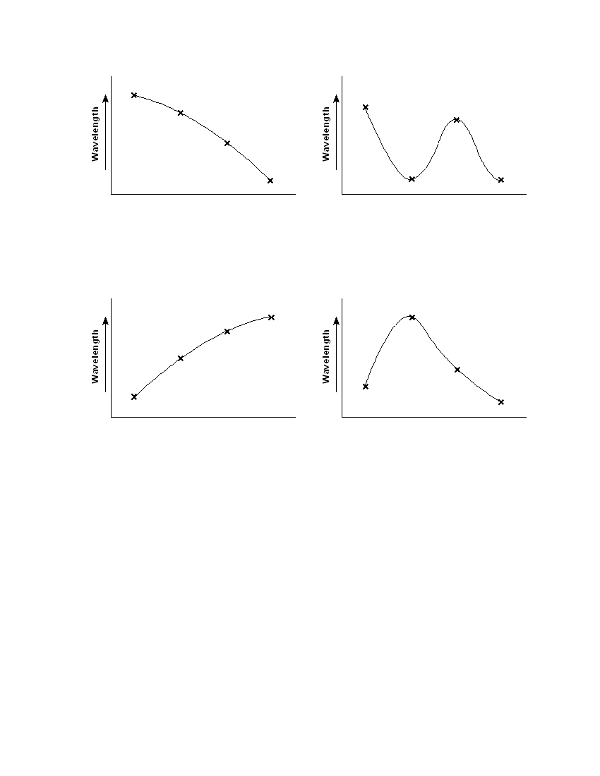
33 Which graph best represents the relative wavelengths of the different forms of electromagnetic energy?
X rays
Infrared
Micro-
Radio
X rays
Infrared
Micro-
Radio
waves
waves
waves
waves
waves
waves
Form of Electromagnetic Energy
Form of Electromagnetic Energy
( 1 )
( 3 )
X rays
Infrared
Micro-
Radio
X rays
Infrared
Micro-
Radio
waves
waves
waves
waves
waves
waves
Form of Electromagnetic Energy
Form of Electromagnetic Energy
( 2 )
( 4 )
P.S./E. Sci.–Jan. ’06
[8]

34 The three statements below are observations of
35 Most rock gypsum is formed by the
the same rock sample:
(1) heating of previously existing foliated
bedrock
millimeters in diameter.
(2) cooling and solidification of lava
(3) compaction and cementation of shells and
green olivine, green pyroxene, and black
skeletal remains
amphibole.
(4) chemical precipitation of minerals from sea-
water
This rock sample is most likely
(1) sandstone
(3) granite
(2) gabbro
(4) phyllite
P.S./E. Sci.–Jan. ’06
[9]
[OVER]
Part B–1
Answer all questions in this part.
Directions (36–50): For each statement or question, write on your separate answer sheet the number of the
word or expression that, of those given, best completes the statement or answers the question. Some questions
may require the use of the Earth Science Reference Tables .
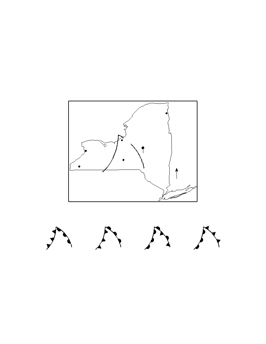
Base your answers to questions 36 through 38 on the weather map below and on your knowledge of Earth
science. The weather map shows a typical low-pressure system and associated weather fronts labeled A and B .
The L indicates the center of the low-pressure system. A few New York State cities are shown. Symbols cP and
mT represent different air masses. The wind direction at Utica and Rochester is shown on the station models.
Plattsburgh
L
cP
cP
Oswego
Rochester
Utica
Buffalo
mT
Ithaca
Jamestown
N
B
A
36 Which front symbols are drawn correctly, based on the air masses shown?
L
L
L
L
B
B
B
B
A
A
A
A
( 1 )
( 2 )
( 3 )
( 4 )
37 If this weather system is following a normal storm track, the center of this low is most
likely moving toward which city?
(1) Buffalo
(3) Utica
(2) Ithaca
(4) Plattsburgh
P.S./E. Sci.–Jan. ’06
[10]
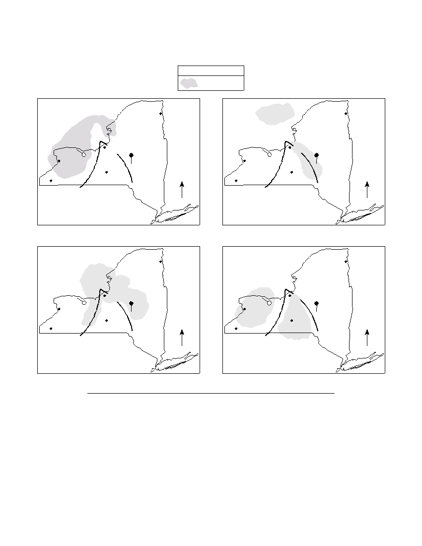
38 Which map shows the regions that are most likely experiencing the precipitation
associated with this weather system?
Key
Precipitation
Plattsburgh
Plattsburgh
L
L
cP
cP
cP
Oswego
Oswego
cP
Rochester
Utica
Rochester
Utica
Buffalo
mT
Buffalo
mT
Ithaca
Ithaca
Jamestown
N
Jamestown
N
A
B
A
B
( 1 )
( 3 )
Plattsburgh
Plattsburgh
L
L
cP
cP
cP
Oswego
Oswego
cP
Rochester
Utica
Rochester
Utica
Buffalo
mT
Buffalo
mT
Ithaca
Ithaca
Jamestown
N
Jamestown
N
A
B
A
B
( 2 )
( 4 )
P.S./E. Sci.–Jan. ’06
[11]
[OVER]
Base your answers to questions 39 through 41 on the diagram below and on your knowledge of Earth
science. The diagram shows a pin perpendicular to a card. The card was placed outdoors in the sunlight on a
horizontal surface. The positions of the pin’s shadow on the card were recorded several times on March 21 by
an observer in New York State.
Pin
8 a.m.
10 a.m.
Noon
Pin shadows
(Drawn to scale)
39 Which diagram best represents the length of the pin’s shadow at 2 p.m. on March 21?
Pin
Pin
8a.m.
8a.m.
10 a.m.
10 a.m.
2 p.m.
Noon
2 p.m.
Noon
Pin shadows
Pin shadows
( 1 )
( 3 )
Pin
Pin
8a.m.
8a.m.
2 p.m.
2 p.m.
10 a.m.
10 a.m.
Noon
Noon
Pin shadows
Pin shadows
( 2 )
( 4 )
P.S./E. Sci.–Jan. ’06
[12]
40 The changing location of the pin’s shadow on March 21 is caused by
(1) the Sun’s rotation
(3) Earth’s rotation
(2) the Sun’s revolution
(4) Earth’s revolution
41 On June 21, the card and pin were placed in the same position as they were on
March 21. The diagram below shows the positions of the pin’s shadow.
Pin
8 a.m.
10 a.m.
Noon
Pin shadows
(Drawn to scale)
Which statement best explains the decreased length of each shadow on June 21?
(1) The Sun’s apparent path varies with the seasons.
(2) The Sun’s distance from Earth varies with the seasons.
(3) The intensity of insolation is lower on June 21.
(4) The duration of insolation is shorter on June 21.
P.S./E. Sci.–Jan. ’06
[13]
[OVER]
Base your answers to questions 42 through 46 on the two tables below and on your knowledge of Earth
science. Table 1 shows the composition, hardness, and average density of four minerals often used as gemstones.
Table 2 lists the minerals in Moh’s Scale of Hardness from 1 (softest) to 10 (hardest).
Table 1
Gemstone Mineral Composition
Hardness
Average Density
(g/cm 3 )
emerald
Be 3 Al 2 (Si 6 O 18 )
7.5–8
2.7
sapphire
Al 2 O 3
9
4.0
spinel
MgAl 2 O 4
8
3.8
zircon
ZrSiO 4
7.5
4.7
KEY
Al = aluminum
O = oxygen
Be = beryllium
Si = silicon
Mg = magnesium
Zr = zirconium
Table 2
Moh’s Scale
of Hardness
1 talc
2 gypsum
3 calcite
4 fluorite
5 apatite
6 feldspar
7 quartz
8 topaz
9 corundum
10 diamond
42 Part of a gemstone’s value is based on the way the gemstone shines in reflected light.
The way a mineral reflects light is described as the mineral’s
(1) fracture
(3) luster
(2) hardness
(4) streak
P.S./E. Sci.–Jan. ’06
[14]

43 Sapphire is a gemstone variety of which mineral on Moh’s scale of hardness?
(1) corundum
(3) fluorite
(2) diamond
(4) topaz
44 If the mass of a spinel crystal is 9.5 grams, what is the volume of this spinel crystal?
(1) 0.4 cm 3
(3) 5.7 cm 3
(2) 2.5 cm 3
(4) 36.1 cm 3
45 The hardness and density of each gemstone is based primarily on the gemstone’s
(1) internal arrangement of atoms
(3) oxygen content
(2) geologic time of formation
(4) natural abundance
46 Which gemstone minerals contain the two most abundant elements by mass in
Earth’s crust?
(1) emerald and spinel
(3) sapphire and spinel
(2) emerald and zircon
(4) sapphire and zircon
P.S./E.Sci.–Jan. ’06
[15]
[OVER]
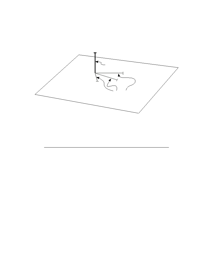
Base your answers to questions 47 through 50 on the cross section below and on your knowledge of Earth
science. The cross section shows the general movement of air within a portion of Earth’s atmosphere located
between 30° N and 30° S latitude. Numbers 1 and 2 represent different locations in the atmosphere.
1
1
2
2
30 ° N
0 °
30 ° S
Earth’s
Latitude
surface
(Not drawn to scale)
47 Which temperature zone layer of Earth’s atmosphere is shown in the cross section?
(1) troposphere
(3) mesosphere
(2) stratosphere
(4) thermosphere
48 The air movement shown in the cross section is due to the process of
(1) condensation
(3) evaporation
(2) conduction
(4) convection
49 What is the approximate percentage by volume of oxygen present in Earth’s atmo-
sphere at location 2?
(1) 10%
(3) 33%
(2) 21%
(4) 46%
P.S./E. Sci.–Jan. ’06
[16]
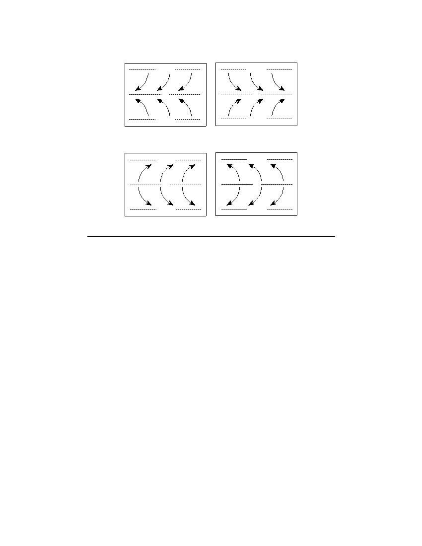
50 Which map best shows the surface movement of winds between 30 ° N and 30 ° S
latitude?
30 ° N
30 ° N
0 °
0 °
30 ° S
30 ° S
( 1 )
( 3 )
30 ° N
30 ° N
0 °
0 °
30 ° S
30 ° S
( 2 )
( 4 )
P.S./E.Sci.–Jan. ’06
[17]
[OVER]
Part B–2
Answer all questions in this part.
Directions (51–65): Record your answers in the spaces provided in your answer booklet. Some questions
may require the use of the Earth Science Reference Tables.
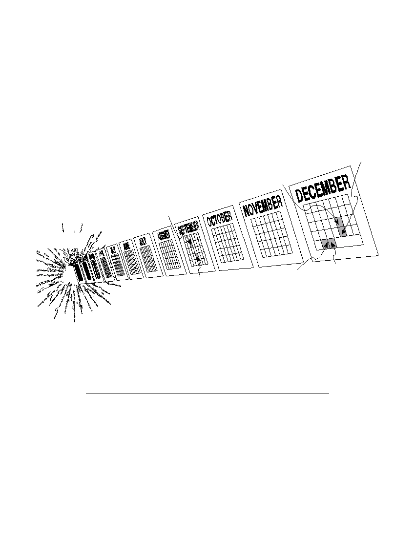
Base your answers to questions 51 and 52 on the calendar model shown below of the inferred history of the
universe and on your knowledge of Earth science. The 12-month time line begins with the Big Bang on
January 1 and continues to the present time, which is represented by midnight on December 31. Several
inferred events and the relative times of their occurrence have been placed in the appropriate locations on the
time line.
December 26
December 19
Earliest dinosaurs
The first vertebrates
(animals with a
backbone)
September 10
The formation of
Earth and our solar
system
January 1
The Big Bang
December 31
December 30
late evening
September 25
The extinction
The first humans
The formation of
of dinosaurs
the oldest microfossil
51 State one piece of evidence used by scientists to support the theory that the Big Bang
event occurred. [ 1 ]
52 How many million years of Earth’s geologic history elapsed between the event that
occurred on September 10 and the event that occurred on September 25 in this
model? [ 1 ]
P.S./E.Sci.–Jan. ’06
[18]
Base your answers to questions 53 through 56 on the world map in your answer booklet and on your
knowledge of Earth science. The map shows major earthquakes and volcanic activity occurring from 1996
through 2000. Letter A represents a volcano on a crustal plate boundary.
53 In your answer booklet , place an X on the map to show the location of the Nazca
Plate. [ 1 ]
54 Explain why most major earthquakes are found in specific zones instead of being
randomly scattered across Earth’s surface. [ 1 ]
55 Identify the source of the magma for the volcanic activity in Hawaii. [ 1 ]
56 Identify the type of plate movement responsible for the presence of the volcano at
location A . [ 1 ]
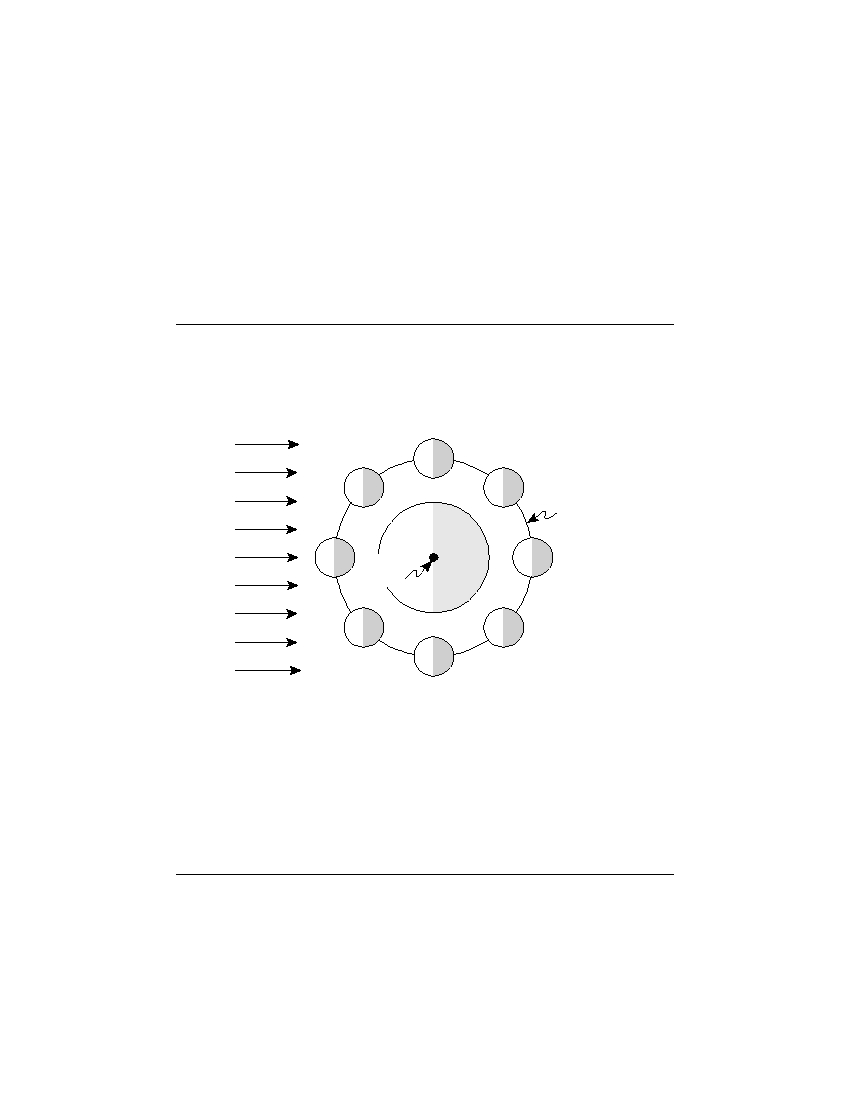
Base your answers to questions 57 through 59 on the diagram below, which shows the Moon’s orbit around
Earth. Four positions of the Moon are represented by letters A , B , C , and D . Earth’s North Pole is labeled. The
shaded areas on Earth and the Moon represent night.
D
Moon’s orbit
Earth
Sun’s
rays
A
North
C
Pole
B
(Not drawn to scale)
57 What motion of the Moon results in the Moon phases as viewed from Earth? [ 1 ]
58 A total solar eclipse sometimes occurs when the Moon is at position A . Explain why
a total solar eclipse does not occur every time the Moon is at position A . [ 1 ]
59 State one season that begins when the line separating day and night passes through
Earth’s North Pole, as shown in this diagram. [ 1 ]
P.S./E. Sci.–Jan. ’06
[19]
[OVER]
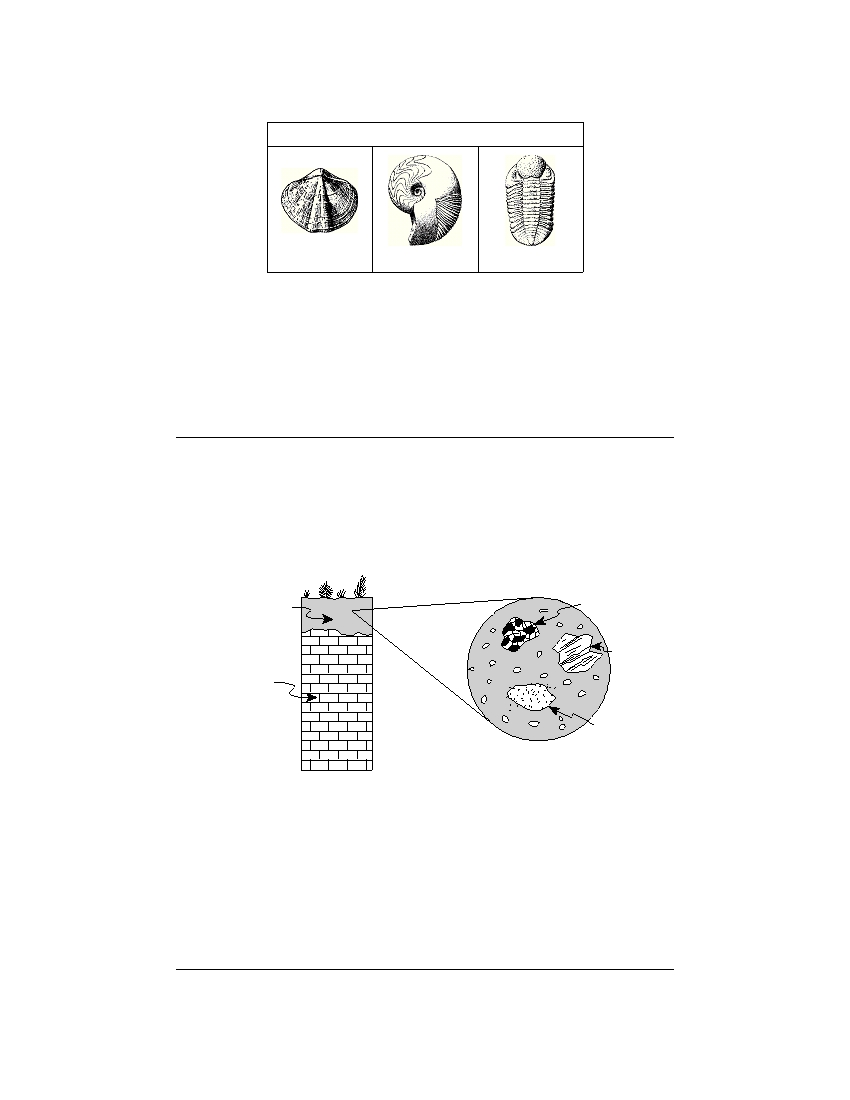
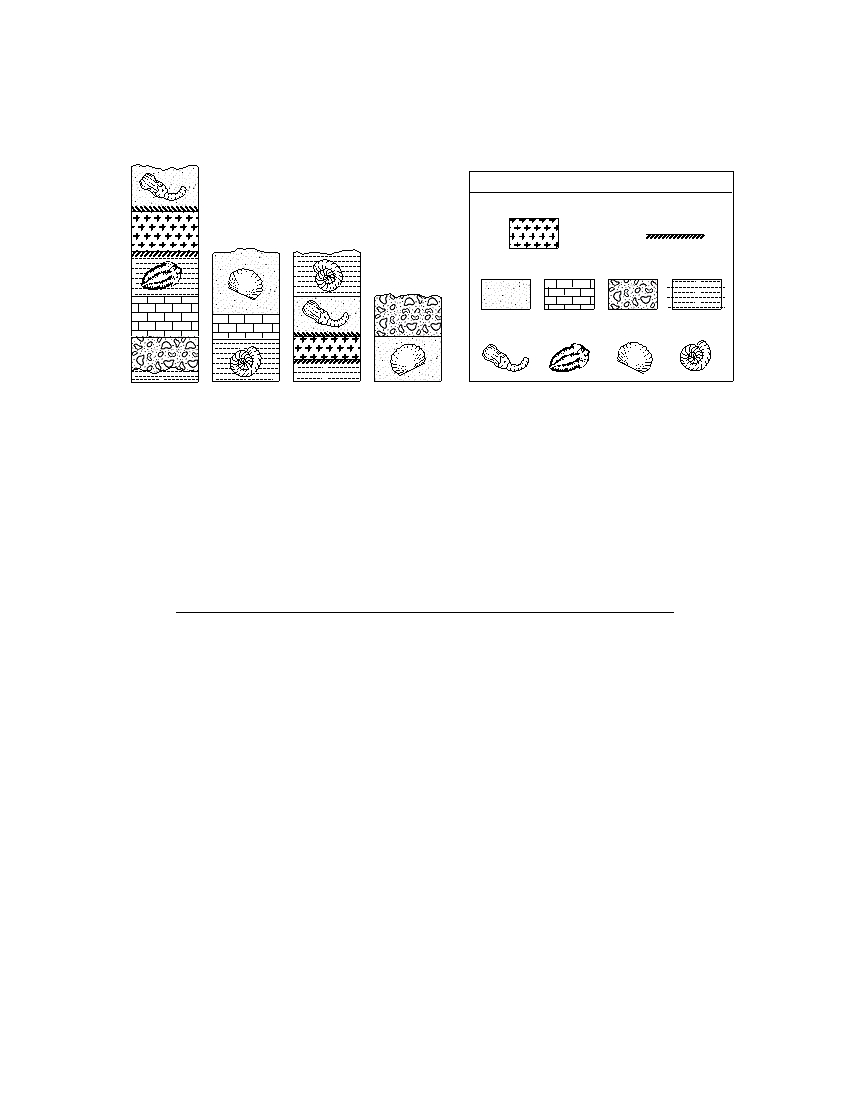
Base your answers to questions 60 through 62 on the table of index fossils shown below and on your
knowledge of Earth science.
Table of Index Fossils
Eospirifer
Manticoceras
Phacops
60 During what geologic time period did the oldest index fossil shown in this table
exist? [ 1 ]
61 State one characteristic of a good index fossil. [ 1 ]
62 Complete the classification table in your answer booklet by filling in the general
fossil group name for each index fossil. [ 1 ]
Base your answers to questions 63 through 65 on the cross section below, which shows an area near
Watertown, New York. The top layer of soil contains broken rock fragments. A representative sample of this
layer has been magnified.
Cross Section
Magnified View
Soil with broken
Granite
rock fragments
Gneiss
Unweathered
limestone
bedrock
Sandstone
63 Identify one mineral that could be found in all three rock fragments shown in the
magnified view. [ 1 ]
64 State one observable characteristic, other than mineral composition, that could help
identify the gneiss fragment. [ 1 ]
65 Rocks and minerals are natural resources that are mined in New York State. State
one negative impact that should be considered before mining these natural
resources. [ 1 ]
P.S./E. Sci.–Jan. ’06
[20]

Part C
Answer all questions in this part.
Directions (66–83): Record your answers in the spaces provided in your answer booklet. Some questions
may require the use of the Earth Science Reference Tables.
Base your answers to questions 66 through 68 on the information below, which describes the past and
present climate of Antarctica, and on your knowledge of Earth science.
Antarctica’s ice sheet has an average thickness of 6600 feet and holds approxi-
mately 70% of Earth’s freshwater. Ice layers in Antarctica preserve information about
Earth’s history. Fossil evidence found in the bedrock of this continent shows that
Antarctica was once tropical and is a potential source of untapped natural resources.
Antarctica is now a frozen desert with very little snowfall.
66 Explain why Antarctica’s cold climate is responsible for its very low amount of
yearly precipitation. [ 1 ]
67 What evidence is preserved in Antarctica that provides information about Earth’s
past climates? [ 1 ]
68 Scientists are concerned that the Antarctic ice may melt as the result of global
warming. State one effect that this melting would most likely have on Long Island,
New York. [ 1 ]
P.S./E. Sci.–Jan. ’06
[21]
[OVER]
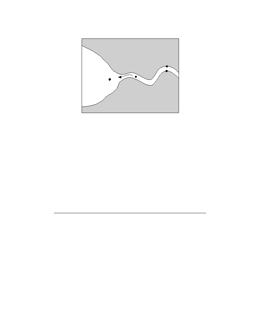
Base your answers to questions 69 through 73 on the map below, which shows a meandering stream as it
enters a lake. Points A through D represent locations in the stream.
A
B
Lake
D
C
69 In the box in your answer booklet , draw a cross-sectional view of the general shape
of the stream bottom between points A and B . The water surface line has already
been drawn. [ 1 ]
70 State the relationship between stream velocity and the size of the sediment the
stream can carry. [ 1 ]
71 Describe how the size and shape of most pebbles change when the pebbles are
transported in a stream over a great distance. [ 1 ]
72 The stream velocity at point C is 100 centimeters per second and the stream
velocity at point D is 40 centimeters per second. Identify one sediment particle most
likely being deposited between points C and D . [ 1 ]
73 Deposition is affected by particle density. On the grid in your answer booklet , draw
a line to show the relationship between particle density and settling rate. [ 1 ]
P.S./E. Sci.–Jan. ’06
[22]

Base your answers to questions 74 through 77 on the passage below, the map in your answer booklet, and
your knowledge of Earth science. The map shows ocean depths, measured in meters, off the coast of
Massachusetts. Points A, B , and C represent locations on the ocean floor. The Stellwagen Bank discussed in the
passage is lightly shaded and labeled on the map.
The Stellwagen Bank
One of the most exciting adventures for a visitor to Cape Cod, Massachusetts, is
going on a whale watch. Large boats leave port two to three times each day carrying
passengers to a specific location in the Atlantic Ocean to see the whales. How do the
captains of the boats know where to find the whales?
The answer is simple. They look for the whales over an area known as the
Stellwagen Bank, which is a large undersea deposit of unsorted sand and gravel. The
Stellwagen Bank is inferred by scientists to have formed during the Pleistocene Epoch
from the slow retreat of massive Ice Age glaciers across this area. Today, cool ocean
currents come from the north and flow up and over the Stellwagen Bank. These
currents bring nutrients to the surface from deep in the ocean, providing food for
oceanic phytoplankton (small plants). Small ocean creatures and fish feed on the
phytoplankton. Whales can be found in abundance at the Stellwagen Bank feeding on
the many ocean life-forms.
74 Most whale watching takes place at 42° 25 ′ N and 70° 25 ′ W. On the map in your
answer booklet , place an X at this location. [ 1 ]
75 Identify the most probable cold ocean current causing the upwelling of nutrients
over the Stellwagen Bank. [ 1 ]
76 What evidence indicates that the ocean floor has a steep slope at point C ? [ 1 ]
77 Calculate the average ocean-floor gradient between point A and point B . Label your
answer with the correct units. [ 2 ]
P.S./E. Sci.–Jan. ’06
[23]
[OVER]

Base your answers to questions 78 through 80 on the data table below and on your knowledge of Earth
science. Iridium is an element rarely found in Earth’s lithosphere but commonly found in asteroids. The data
table shows the abundance of iridium, in parts per billion (ppb), found in a rock core sample taken in Carlsbad,
New Mexico.
Iridium Abundance in a Rock Core Sample
Depth Below
Iridium
Earth’s Surface
Abundance
(m)
(ppb)
0
0
50
0
100
0.5
105
0.5
113
0.5
115
13.5
119
0.5
120
0.25
128
0.25
135
0
78 On the grid in your answer booklet , construct a line graph of iridium abundance at
various depths. Place an X to show the iridium abundance at each depth shown on
the data table. Connect the X s with a line. [ 2 ]
79 The high concentration of iridium in this rock core sample has been matched to rock
layers that have been dated to the geologic time when dinosaur extinction from an
asteroid impact may have occurred. Between which two geologic time periods did
this inferred extinction occur? [ 1 ]
80 Other than iridium in the rock layers, what surface feature was most likely created
when this asteroid impacted Earth’s crust? [ 1 ]
P.S./E. Sci.–Jan. ’06
[24]
Base your answers to questions 81 through 83 on the cross sections below, which show widely separated
outcrops at locations W , X , Y , and Z . The rock layers have not been overturned. Line AB in the cross section at
location W represents an unconformity. Fossils are shown in some of the layers.
Location W
Key
Igneous intrusion
Contact
metamorphism
Location X Location Y
Sedimentary rock types
Location Z
Fossil types
A
B
(Not drawn to scale)
81 Determine the relative geologic age of the four fossils by correlating the rock layers
between these outcrops. In your answer booklet , number the fossils from 1 to 4 in
order of relative age, with 1 as the oldest and 4 as the youngest. [ 1 ]
82 What evidence shown in the outcrop at location W suggests that the igneous intru-
sion occurred after both fossils were deposited at location W ? [ 1 ]
83 Identify two of the processes involved in the formation of the unconformity repre-
sented by line AB in the cross section at location W . [ 1 ]
P.S./E. Sci.–Jan. ’06
[25]

The University of the State of New York
R EGENTS H IGH S CHOOL E XAMINATION
PHYSICAL SETTING
EARTH SCIENCE
Wednesday, January 25, 2006 — 9:15 a.m. to 12:15 p.m., only
ANSWER SHEET
Student . . . . . . . . . . . . . . . . . . . . . . . . . . . . . . . . . . . . . . . . . . . . .
Sex:
■ Male ■ Female
Grade . . . . . . . . . . . .
Teacher . . . . . . . . . . . . . . . . . . . . . . . . . . . . . . . . . . . . . . . . . . . . .
School
. . . . . . . . . . . . . . . . . . . . . . . . . . . . . . . . . .
Record your answers to Part A and Part B–1 on this answer sheet.
Part A
Part B–1
1 . . . . . . . . . . .
13 . . . . . . . . . . .
25 . . . . . . . . . . .
36 . . . . . . . . . . .
44 . . . . . . . . . . .
2 . . . . . . . . . . .
14 . . . . . . . . . . .
26 . . . . . . . . . . .
37 . . . . . . . . . . .
45 . . . . . . . . . . .
3 . . . . . . . . . . .
15 . . . . . . . . . . .
27 . . . . . . . . . . .
38 . . . . . . . . . . .
46 . . . . . . . . . . .
4 . . . . . . . . . . .
16 . . . . . . . . . . .
28 . . . . . . . . . . .
39 . . . . . . . . . . .
47 . . . . . . . . . . .
5 . . . . . . . . . . .
17 . . . . . . . . . . .
29 . . . . . . . . . . .
40 . . . . . . . . . . .
48 . . . . . . . . . . .
6 . . . . . . . . . . .
18 . . . . . . . . . . .
30 . . . . . . . . . . .
41 . . . . . . . . . . .
49 . . . . . . . . . . .
7 . . . . . . . . . . .
19 . . . . . . . . . . .
31 . . . . . . . . . . .
42 . . . . . . . . . . .
50 . . . . . . . . . . .
Part B–1 Score
8 . . . . . . . . . . .
20 . . . . . . . . . . .
32 . . . . . . . . . . .
43 . . . . . . . . . . .
9 . . . . . . . . . . .
21 . . . . . . . . . . .
33 . . . . . . . . . . .
10 . . . . . . . . . . .
22 . . . . . . . . . . .
34 . . . . . . . . . . .
11 . . . . . . . . . . .
23 . . . . . . . . . . .
35 . . . . . . . . . . .
Part A Score
12 . . . . . . . . . . .
24 . . . . . . . . . . .
Write your answers to Part B–2 and Part C in your answer booklet.
The declaration below should be signed when you have completed the examination.
I do hereby affirm, at the close of this examination, that I had no unlawful knowledge of the questions or answers prior to
the examination and that I have neither given nor received assistance in answering any of the questions during the examination.
Signature

PS/EARTH SCIENCE
E C N E I C S H T R A E / S P