
PS/EARTH SCIENCE
The University of the State of New York
REGENTS HIGH SCHOOL EXAMINATION
PHYSICAL SETTING
EARTH SCIENCE
Wednesday, January 24, 2007 — 9:15 a.m. to 12:15 p.m., only
This is a test of your knowledge of Earth science. Use that knowledge to answer
all questions in this examination. Some questions may require the use of the Earth
Science Reference Tables. The Earth Science Reference Tables are supplied separately.
Be certain you have a copy of the 2001 edition of these reference tables before you
begin the examination.
Your answer sheet for Part A and Part B–1 is the last page of this examination
booklet. Turn to the last page and fold it along the perforations. Then, slowly and
carefully, tear off your answer sheet and fill in the heading.
The answers to the questions in Part B–2 and Part C are to be written in your
separate answer booklet. Be sure to fill in the heading on the front of your answer
booklet.
You are to answer all questions in all parts of this examination according to the
directions provided in the examination booklet. Record your answers to the Part A
and Part B–1 multiple-choice questions on your separate answer sheet. Write your
answers to the Part B–2 and Part C questions in your answer booklet. All work should
be written in pen, except for graphs and drawings, which should be done in pencil.
You may use scrap paper to work out the answers to the questions, but be sure to
record all your answers on your separate answer sheet and in your answer booklet.
When you have completed the examination, you must sign the statement printed
at the end of your separate answer sheet, indicating that you had no unlawful
knowledge of the questions or answers prior to the examination and that you have
neither given nor received assistance in answering any of the questions during the
examination. Your answer sheet and answer booklet cannot be accepted if you fail to
sign this declaration.
Notice. . .
A four-function or scientific calculator and a copy of the 2001 Earth Science Reference Tables
must be available for you to use while taking this examination.
The use of any communications device is strictly prohibited when taking this
examination. If you use any communications device, no matter how briefly, your
examination will be invalidated and no score will be calculated for you.
DO NOT OPEN THIS EXAMINATION BOOKLET UNTIL THE SIGNAL IS GIVEN.
E C N E I C S H T R A E / S P
Part A
Answer all questions in this part.
Directions (1–35): For each statement or question, write on your separate answer sheet the number of the
word or expression that, of those given, best completes the statement or answers the question. Some questions
may require the use of the Earth Science Reference Tables .
1 Which object in our solar system has the greatest
4 The diagram below shows the equipment used to
density?
demonstrate a Foucault pendulum.
(1) Jupiter
(3) the Moon
(2) Earth
(4) the Sun
Stick
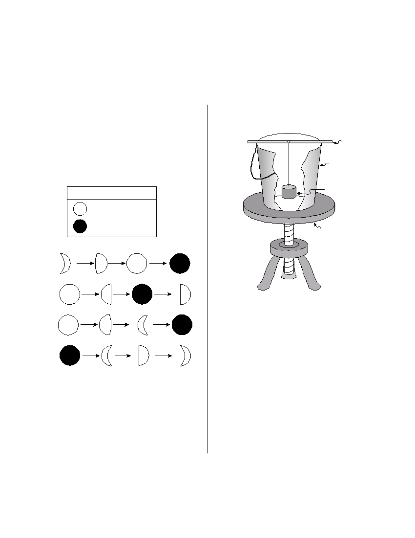
2 Which sequence of Moon phases could be
Pail
observed from Earth during a 2-week period?
Key
Weight
Full Moon phase
New Moon phase
Stool
( 1 )
( 2 )
In the demonstration, a student swings the
weight hanging in the pail and then spins the
( 3 )
stool. The stool represents
(1) the revolving Earth
(2) the rotating Earth
( 4 )
(3) the Coriolis effect
(4) convection currents
3 What is the main reason that the gravitational
5 If Earth’s axis were tilted less than 23.5°, which
attraction between Earth and the Moon changes
seasonal average temperature change would
each day?
occur in New York State?
(1) Earth’s axis is tilted at 23.5°.
(1) Spring and fall would be cooler.
(2) Earth’s rotational speed varies with the
(2) Spring and fall would be warmer.
seasons.
(3) Winter would be cooler.
(3) The Moon has an elliptical orbit.
(4) Summer would be cooler.
(4) The Moon has a spherical shape.
P.S./E. Sci.–Jan ’07
[2]
6 Which list shows stars in order of increasing
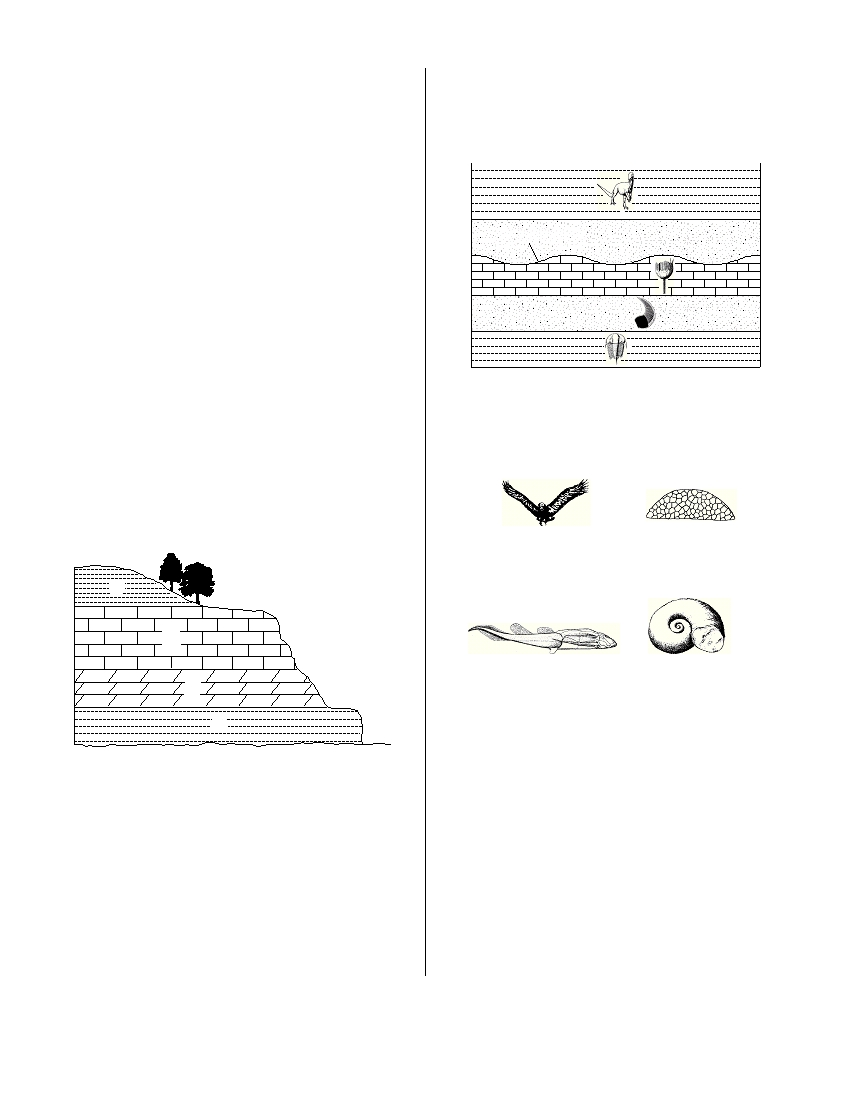
11 The geologic cross section below shows an
temperature?
unconformity in New York State bedrock layers
(1) Barnard’s Star , Polaris , Sirius , Rigel
that have not been overturned. Index fossils
(2) Aldebaran , the Sun , Rigel , Procyon B
found throughout some rock layers are shown.
(3) Rigel , Polaris , Aldebaran , Barnard’s Star
(4) Procyon B , Alpha Centauri , Polaris , Betelgeuse
7 Which group of organisms is inferred to have
existed for the least amount of time in
Unconformity
geologic history?
(1) trilobites
(3) eurypterids
(2) dinosaurs
(4) placoderm fish
8 Which weather variable can be determined by
using a psychrometer?
(1) barometric pressure
(Not drawn to scale)
(2) cloud cover
(3) relative humidity
Which New York State index fossil may have
(4) wind speed
been present in a rock layer that is missing due to
the unconformity?
9 The cross section below shows sedimentary
bedrock layers A , B , C , and D exposed at Earth’s
surface.
Condor
Lichenaria
( 1 )
( 3 )
A
B
Bothriolepis
Maclurites
C
( 2 )
( 4 )
D
12 Most scientists believe the Milky Way Galaxy is
Which layer appears to be the least resistant to
(1) spherical in shape
weathering?
(2) 4.6 billion years old
(3) composed of stars revolving around Earth
(1) A
(3) C
(4) one of billions of galaxies in the universe
(2) B
(4) D
10 Which rock was organically formed and some-
times contains fossilized plant impressions?
(1) rock gypsum
(3) breccia
(2) phyllite
(4) coal
P.S./E. Sci.–Jan ’07
[3]
[OVER]
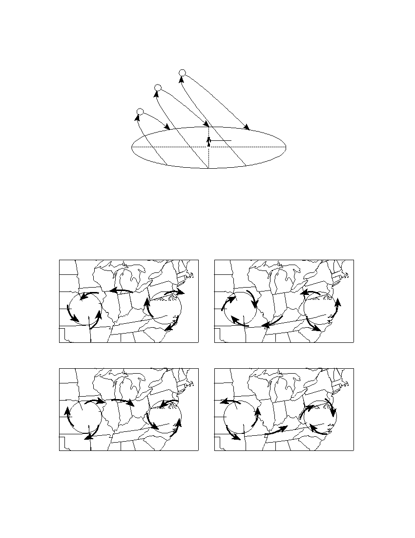
13 The diagram below shows the apparent daily path of the Sun, as viewed by an observer at a certain latitude
on three different days of the year.
June 21
March 21
Dec 21
West
Sunset
Observer
South
North
East
Sunrise
At which latitude were these apparent Sun paths most likely observed?
(1) 0°
(3) 43° N
(2) 23.5° N
(4) 66.5° N
14 Which map best represents the surface wind pattern associated with high-pressure and low-pressure
systems in the Northern Hemisphere?
High
Low
High
Low
pressure
pressure
pressure
pressure
( 1 )
( 3 )
High
Low
High
Low
pressure
pressure
pressure
pressure
( 2 )
( 4 )
P.S./E. Sci.–Jan ’07
[4]
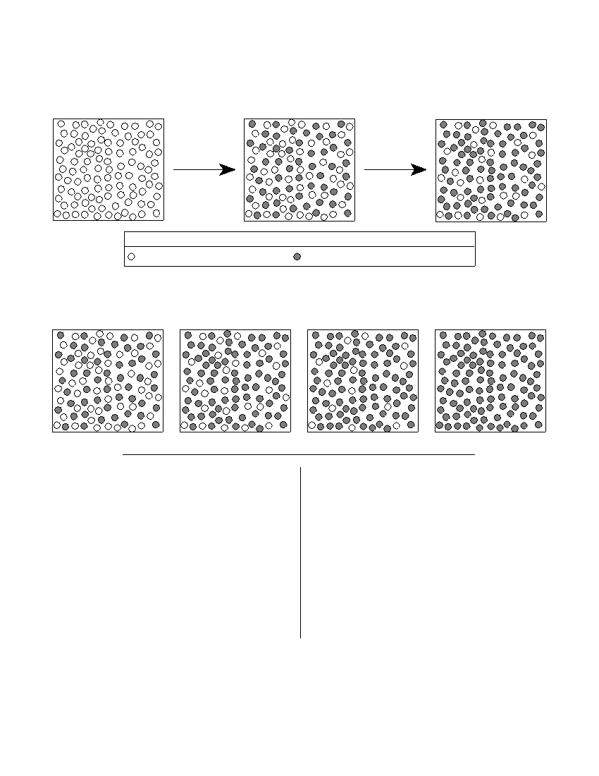
15 The models below represent the decay of radioactive atoms to stable atoms after their first and second
half-lives.
Original sample of
Atoms after
Atoms after
undecayed atoms
one half-life
two half-lives
Key
Undecayed radioactive atom
Decayed atom (stable end product)
Which model best represents the number of undecayed and decayed atoms after three
half-lives?
( 1 )
( 2 )
( 3 )
( 4 )
16 Which sediment size would allow water to flow
18 The mineral graphite is often used as
through at the fastest rate?
(1) a lubricant
(1) clay
(3) sand
(2) an abrasive
(2) silt
(4) pebbles
(3) a source of iron
(4) a cementing material
17 Large oceans moderate the climatic tempera-
tures of surrounding coastal land areas because
19 In which Earth layer are most convection
the temperature of ocean water changes
currents that cause seafloor spreading thought to
(1) rapidly, due to water’s low specific heat
be located?
(2) rapidly, due to water’s high specific heat
(1) crust
(3) outer core
(3) slowly, due to water’s low specific heat
(2) asthenosphere
(4) inner core
(4) slowly, due to water’s high specific heat
P.S./E. Sci.–Jan ’07
[5]
[OVER]
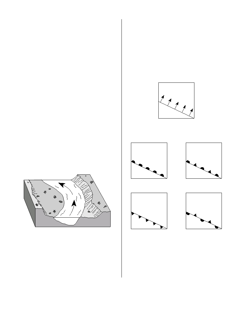
20 Which weather map symbol represents air masses
24 Which agent of erosion is mainly responsible for
that normally form just south of the United States
the formation of the depressions occupied by
over the Caribbean Sea?
both the kettle lakes and finger lakes found in
(1) cP
(3) mP
New York State?
(2) cT
(4) mT
(1) wind
(3) streams
(2) waves
(4) glaciers
21 An earthquake’s magnitude can be determined
by
25 The map below shows the boundary between two
(1) analyzing the seismic waves recorded by a
air masses. The arrows show the direction in
seismograph
which the boundary is moving.
(2) calculating the depth of the earthquake
faulting
(3) calculating the time the earthquake occurred
(4) comparing the speed of P -waves and S- waves
cP
22 A seismic station is recording the seismic waves
produced by an earthquake that occurred
mT
4200 kilometers away. Approximately how long
after the arrival of the first P -wave will the first
S -wave arrive?
Which weather map uses the correct weather
front symbol to illustrate this information?
(1) 1 min 05 sec
(3) 7 min 20 sec
(2) 5 min 50 sec
(4) 13 min 10 sec
23 The diagram below shows a section of a meander
in a stream. The arrows show the direction of
stream flow.
cP
cP
mT
mT
( 1 )
( 3 )
cP
cP
mT
mT
( 2 )
( 4 )
The streambank on the outside of this meander is
steeper than the streambank on the inside of this
meander because the water on the outside of this
26 If a low-pressure system follows a typical storm
meander is moving
track across New York State, it will move toward
(1) slower, causing deposition
the
(2) faster, causing deposition
(1) southeast
(3) northeast
(3) slower, causing erosion
(2) southwest
(4) northwest
(4) faster, causing erosion
P.S./E. Sci.–Jan. ’07
[6]
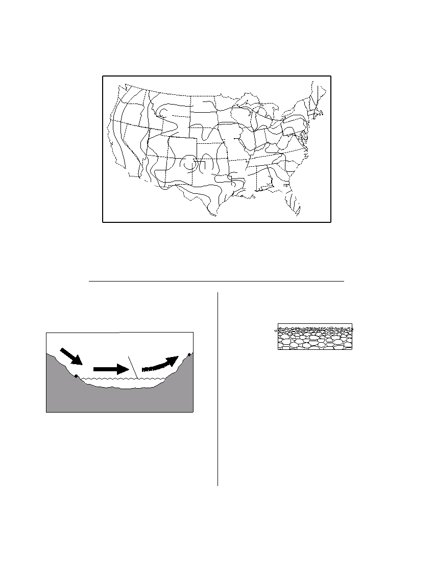
27 The map below shows the average number of thunderstorms during the year in the continental United
States.
Average Number of Thunderstorms Each Year
5
10
20
20
30
40
20
40
30
50
40
60
50
5
40
60
50
10
60
60
20
70
50
70
80
90
80
40
70
30
Which New York State landscape region normally experiences the most thunder-
storms?
(1) Allegheny Plateau
(3) Adirondack Mountains
(2) Taconic Mountains
(4) Champlain Lowlands
28 The arrows in the cross section below show the
29 The cross section below shows a profile of a
prevailing winds moving across northern New
sediment deposit.
York State into Vermont during the summer.
Lake
Champlain
B
(Drawn to scale)
A
The pattern of sediment size shown indicates
that these sediments were most likely deposited
New York
Vermont
within a
(1) landslide
(3) moraine
(2) drumlin
(4) delta
(Not drawn to scale)
Compared to the climate of location A , the climate
of location B is
(1) warmer and wetter
(3) cooler and wetter
(2) warmer and drier
(4) cooler and drier
P.S./E. Sci.–Jan. ’07
[7]
[OVER]
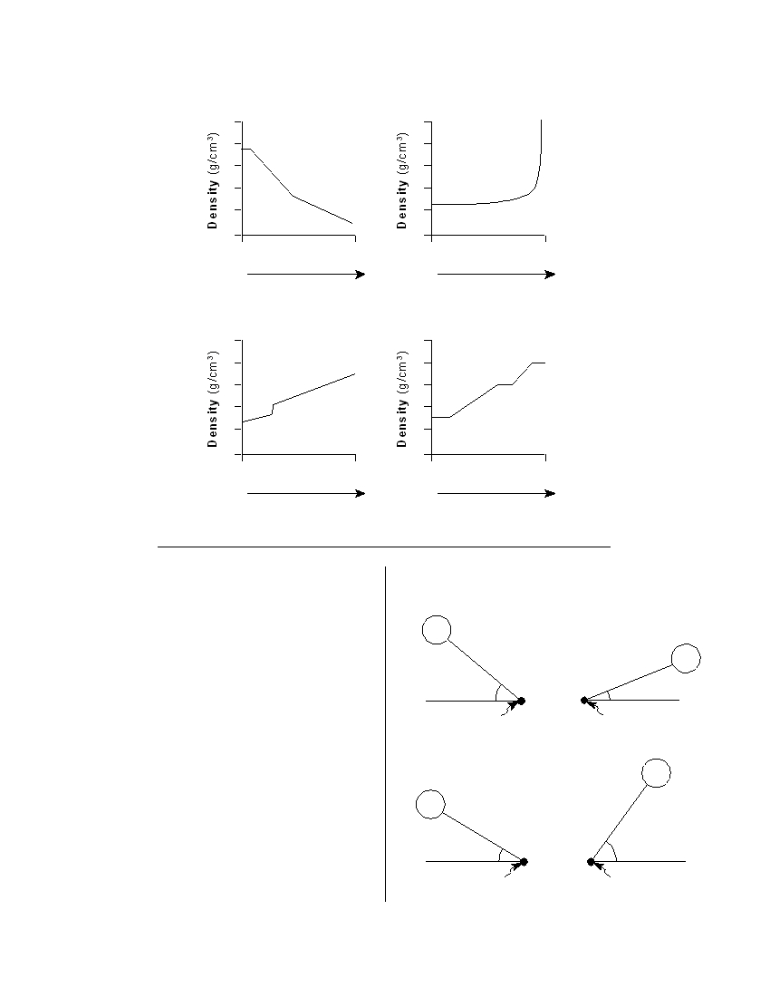
30 Which graph best shows the inferred density of Earth’s interior as depth increases from the upper mantle
to the lower mantle?
7
7
6
6
5
5
4
4
3
3
Upper
Lower
Upper
Lower
mantle
mantle
mantle
mantle
Depth Below Surface
Depth Below Surface
( 1 )
( 3 )
7
7
6
6
5
5
4
4
3
3
Upper
Lower
Upper
Lower
mantle
mantle
mantle
mantle
Depth Below Surface
Depth Below Surface
( 2 )
( 4 )
31 The Catskills landscape region is classified as a
33 In which diagram is the observer experiencing
plateau primarily because the region has
the greatest intensity of insolation?
(1) V-shaped valleys
(2) jagged hilltops
Sun
(3) horizontal bedrock structure
(4) folded metamorphic rock
Sun
40 °
22 °
32 London, England, is located at approximately
51° 30' north latitude and 0° longitude. Elmira,
Observer
Observer
New York, is located at approximately 42° 10' north
( 1 )
( 3 )
latitude and 76° 54' west longitude. What is one
reason why London has a warmer average winter
Sun
temperature than Elmira?
(1) London is located closer to the equator.
Sun
(2) London is located at a higher elevation.
(3) London’s climate is modified by the North
54 °
Atlantic Ocean Current.
31 °
(4) London’s climate is modified by its longer
Observer
Observer
duration of insolation.
( 2 )
( 4 )
P.S./E. Sci.–Jan ’07
[8]
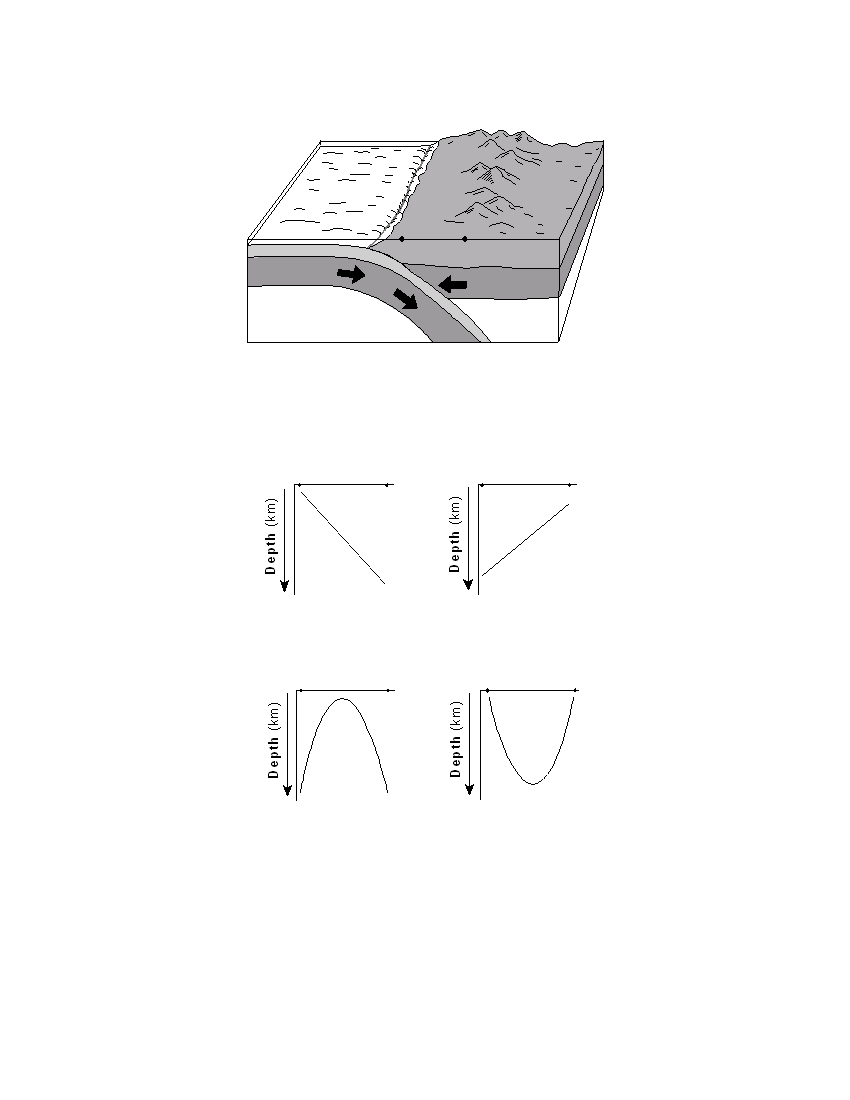
34 The block diagram below shows a tectonic plate boundary. Points A and B represent locations on Earth’s
surface.
T
rench
A
B
O cean ic c r u s t
Continental crust
Rigid mantle
Rigid mantle
Asthenosphere
(Not drawn to scale)
Which graph best shows the depths of most major earthquakes whose epicenters lie
between A and B ?
Earth’s Surface
Earth’s Surface
A
B
A
B
( 1 )
( 3 )
Earth’s Surface
Earth’s Surface
A
B
A
B
( 2 )
( 4 )
P.S./E. Sci.–Jan. ’07
[9]
[OVER]
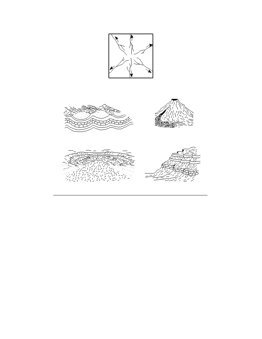
35 The map below shows a stream drainage pattern. Arrows show the direction of stream flow.
On which landscape region did this drainage pattern most likely develop?
( 1 )
( 3 )
( 2 )
( 4 )
P.S./E. Sci.–Jan ’07
[10]

Part B–1
Answer all questions in this part.
Directions (36–50): For each statement or question, write on your separate answer sheet the number of the
word or expression that, of those given, best completes the statement or answers the question. Some questions
may require the use of the Earth Science Reference Tables .
Base your answers to questions 36 through 38 on the geologic cross section below in which overturning has
not occurred. Letters A through H represent rock layers.
A
B
H
C
D
E
F
G
36 Which sequence of events most likely caused the unconformity shown at the bottom
of rock layer B ?
(1) folding → uplift → erosion → deposition
(2) intrusion → erosion → folding → uplift
(3) erosion → folding → deposition → intrusion
(4) deposition → uplift → erosion → folding
37 The folding of rock layers G through C was most likely caused by
(1) erosion of overlying sediments
(3) the collision of lithospheric plates
(2) contact metamorphism
(4) the extrusion of igneous rock
38 Which two letters represent bedrock of the same age?
(1) A and E
(3) F and G
(2) B and D
(4) D and H
P.S./E. Sci.–Jan. ’07
[11]
[OVER]
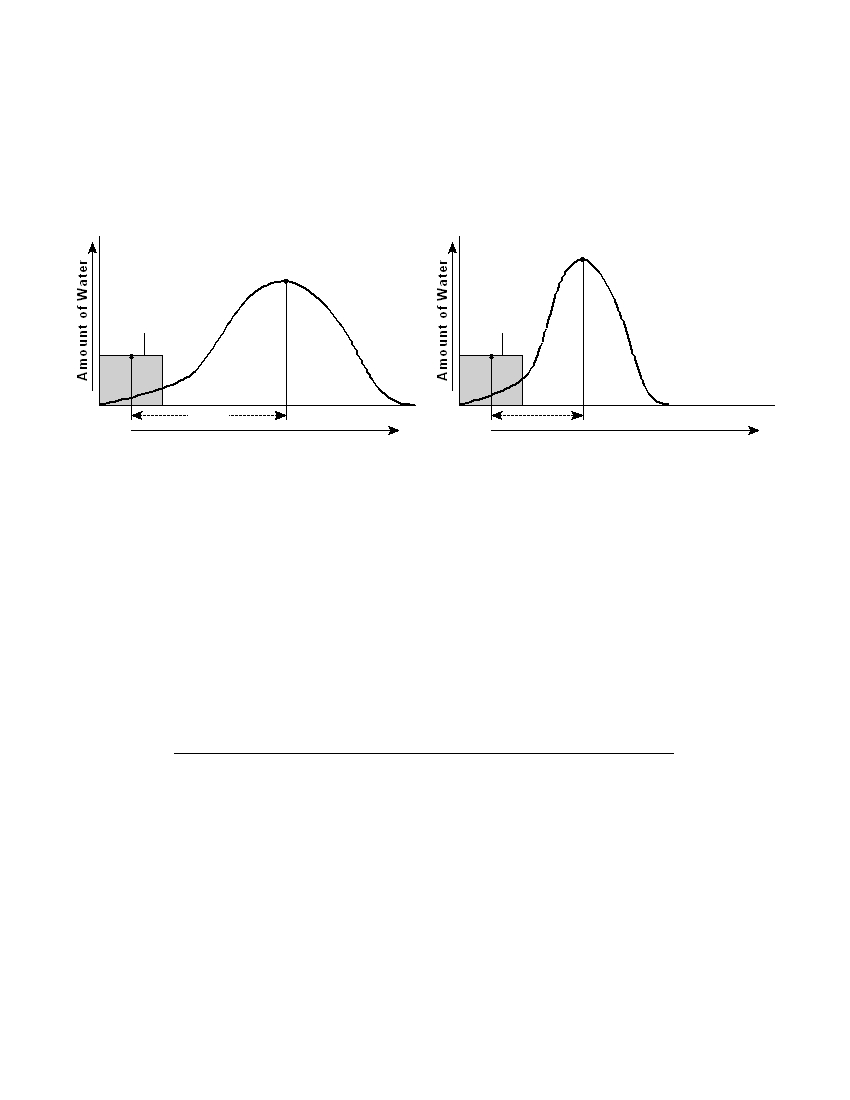
Base your answers to questions 39 and 40 on the two graphs below, which show the relationship between
the amount of rainfall during a storm and the amount of discharge into a nearby stream. Letter A represents
the time when approximately 50% of the precipitation from the storm has fallen. Letter B represents the time
when peak runoff from the storm is flowing into the stream. The delay is the difference in time between
letters A and B on the graph. Graph I shows data before urbanization in an area. Graph II shows data after
urbanization in the same area.
Graph I : Precipitation and Stream
Graph II : Precipitation and Stream
Discharge Before Urbanization
Discharge After Urbanization
B
B
Stream
Stream
discharge
discharge
Precipitation
Precipitation
A
A
Delay
Delay
Time
Time
39 The delay time between points A and B on both graphs is due mainly to the time
needed for
(1) groundwater to evaporate
(2) precipitation water to move into the streams
(3) green plants to absorb precipitation
(4) rainfall rate to decrease
40 How did urbanization affect delay time between points A and B and the maximum
stream discharge?
(1) The delay time decreased, and the maximum discharge decreased.
(2) The delay time decreased, and the maximum discharge increased.
(3) The delay time increased, and the maximum discharge decreased.
(4) The delay time increased, and the maximum discharge increased.
P.S./E. Sci.–Jan ’07
[12]
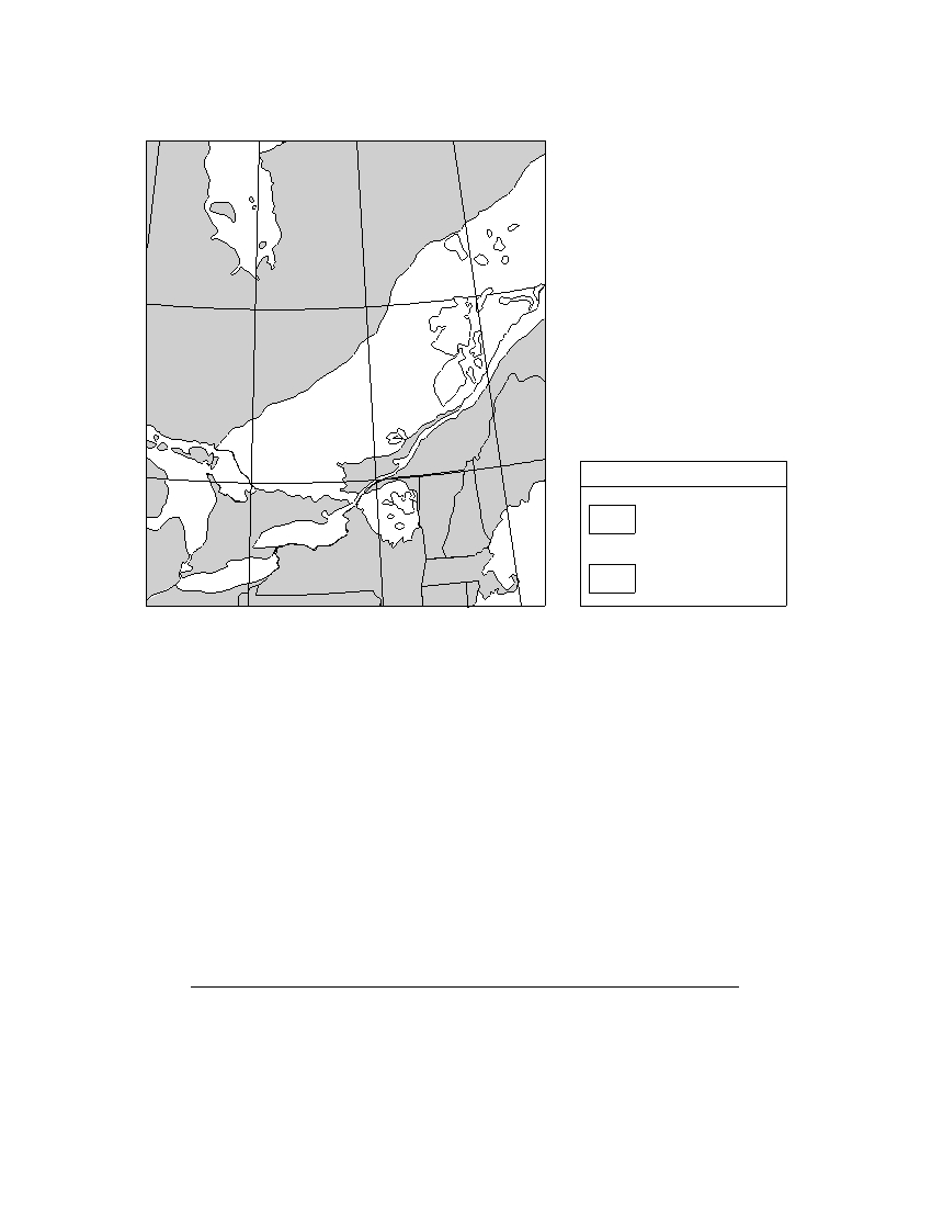
Base your answers to questions 41 through 43 on the map below. The map shows some regions where
metamorphic bedrock of the Grenville Province in northeastern North America is exposed at Earth’s surface.
50 °
C a n a d a
Grenville Province
45 °
Key
Lake
Huron
Mostly gneiss,
Lake Ontario
Atlantic
schist, or marble
Ocean
Lake
Erie
New York State
Anorthosite
80 °
75 °
70 °
41 The bedrock of the Grenville Province is generally thought to have formed
approximately
(1) 250 million years ago
(3) 560 million years ago
(2) 400 million years ago
(4) 1100 million years ago
42 Which New York State location has surface bedrock that consists mainly of
anorthositic rock?
(1) Old Forge
(3) Mt. Marcy
(2) Massena
(4) Utica
43 Which location has surface bedrock that consists mostly of gneiss, schist, or marble?
(1) 43° N 81° W
(3) 47° N 69° W
(2) 46° N 78° W
(4) 49° N 71° W
P.S./E. Sci.–Jan ’07
[13]
[OVER]
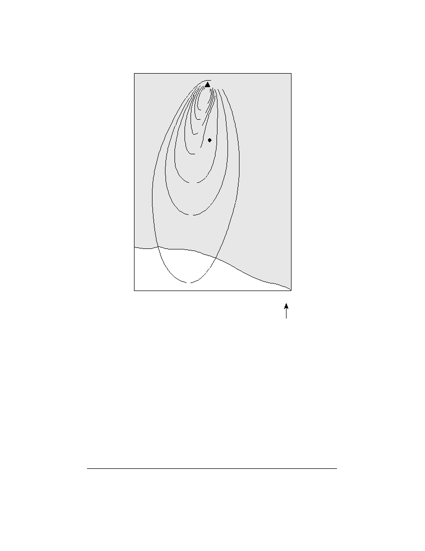
Base your answers to questions 44 through 46 on the map below. The L represents Mt. Hekla, a volcano
in Iceland. The isolines represent the thickness of ash, in centimeters, that settled on Earth’s surface after a
volcanic eruption of Mt. Hekla on March 29, 1947. Point X is a location on the surface of the ash.
Mt. Hekla
100
60
40
30
X
20
10
Iceland
5
Atlantic
1
Ocean
N
44 At the time of the eruption, the wind direction was primarily from the
(1) east
(3) north
(2) west
(4) south
45 How many centimeters thick was the ash beneath point X ?
(1) 0
(3) 20
(2) 15
(4) 25
46 In addition to the ash, solid rock formed on Mt. Hekla from the lava extruded
during this eruption. This rock is most likely
(1) light-colored metamorphic
(3) fine-grained igneous
(2) dark-colored metamorphic
(4) coarse-grained igneous
P.S./E. Sci.–Jan ’07
[14]
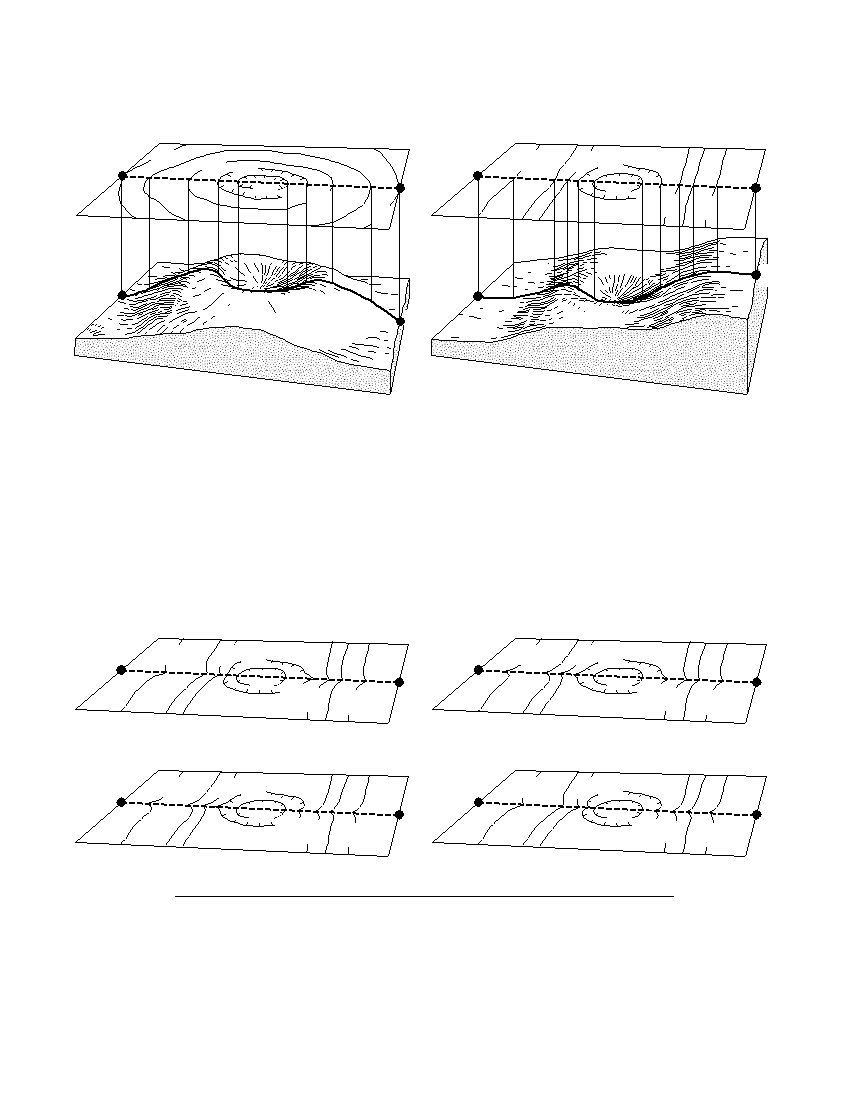
Base your answers to questions 47 and 48 on the topographic maps and block diagrams of two landscape
regions shown below. The block diagrams show a three-dimensional view of the topographic maps directly
above them. Elevations are measured in feet. Points A , B , C , and D are locations on Earth’s surface.
280
A
300 300
300 300
C
280
290
300
B
290
D
300
300
310
280
330
D
A
C
B
Landscape 1
Landscape 2
47 Which contour interval is used on both topographic maps?
(1) 10 ft
(3) 30 ft
(2) 20 ft
(4) 40 ft
48 A stream begins to flow downhill from point D toward the depression. After a
period of time, the depression fills with water. Overflowing water from the
depression moves downhill toward point C . Which topographic map shows the most
likely resulting change in the contour lines?
300 300
300 300
C
280
C
280
290
D
290
D
300
300
310
330
310
330
( 1 )
( 3 )
300 300
300 300
C
280
C
280
290
D
290
D
300
300
310
330
310
330
( 2 )
( 4 )
P.S./E. Sci.–Jan ’07
[15]
[OVER]
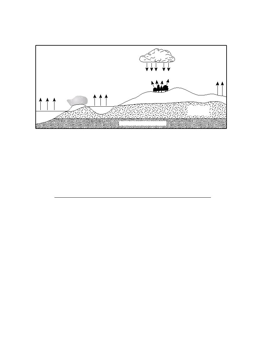
Base your answers to questions 49 and 50 on the cross section below, which represents part of Earth’s water
cycle. Letters A , B , C , and D represent processes that occur during the cycle. The level of the water table and
the extent of the zone of saturation are shown.
Cloud
D
C
B
A
E a rt h ’ s s u
r f a
A
Fog
A
c e
Soil
D
W a t e r t a b l e
Lake
Zone of
saturation
Ocean
Impermeable bedrock
49 Which two letters represent processes in the water cycle that usually cause a
lowering of the water table?
(1) A and B
(3) B and D
(2) A and C
(4) C and D
50 What are two water cycle processes not represented by arrows in this cross section?
(1) transpiration and condensation
(3) precipitation and freezing
(2) evaporation and melting
(4) runoff and infiltration
P.S./E. Sci.–Jan ’07
[16]
Part B–2
Answer all questions in this part.
Directions (51–63): Record your answers in the spaces provided in your answer booklet. Some questions
may require the use of the Earth Science Reference Tables.
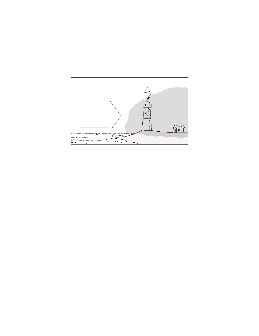
51 The diagram below shows conditions that commonly cause fog to form over land in coastal areas.
Lighthouse
15 knots
Fog
Warm,
moist air
from the
southeast
Cold land surface
A weather station at the lighthouse records a temperature of 36°F and an air pressure
of 1016.4 mb. Using the proper weather map symbols, place the following information
in the correct positions on the weather station model in your answer booklet . [ 2 ]
P.S./E. Sci.–Jan ’07
[17]
[OVER]
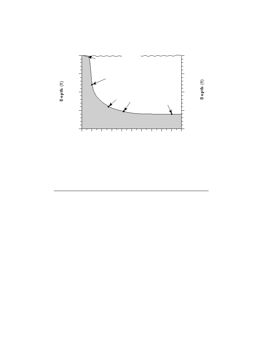
Base your answers to questions 52 and 53 on the cross section below, which represents part of the Atlantic
Ocean seafloor. An earthquake occurred on November 18, 1929, triggering an underwater sediment flow. The
location of the epicenter is labeled. Letters A through D indicate locations on the seafloor. Time, in hours, at
each lettered location represents the arrival of the sediment flow after the earthquake.
North
South
0
Sea level
0
Shelf
Atlantic Ocean
5,000
Epicenter
5,000
0 hour
A
Continental
10,000
10,000
slope
1 hour
3 hours
13 hours
15,000
B
15,000
C
D
Deep seafloor
20,000
20,000
0
100 200 300 400 500 600 700 800 900 1000
Distance from Shore (miles)
52 Calculate the gradient of the ocean floor between locations A and D and label your
answer with the correct units. [ 2 ]
53 Explain why the velocity of the sediment flow created by the earthquake decreased as
the sediment moved from location B to location C . [ 1 ]
P.S./E. Sci.–Jan ’07
[18]

Base your answers to questions 54 through 56 on the data table below, which shows some characteristics of
four rock samples, numbered 1 through 4. Some information has been left blank. All answers must be recorded
in your answer booklet.
Data Table
Rock
Sample
Composition
Grain Size
Texture
Rock Name
Number
1
mostly clay minerals
clastic
shale
foliated with mineral
2
all mica
microscopic, fine
alignment
mica, quartz, feldspar,
3
amphibole, garnet,
medium to coarse
foliated with banding
gneiss
pyroxene
potassium feldspar,
quartz, biotite,
4
5 mm
granite
plagioclase feldspar,
amphibole
54 State a possible grain size, in centimeters, for most of the particles found in sample 1.
[ 1 ]
55 Write the rock name of sample 2. [ 1 ]
56 Write a term or phrase that correctly describes the texture of sample 4. [ 1 ]
Base your answers to questions 57 through 60 on the diagram in your answer booklet, which shows Earth as
seen from above the North Pole. The curved arrows show the direction of Earth’s motion. The shaded portion
represents the nighttime side of Earth. Some of the latitude and longitude lines have been labeled. Points A
and B represent locations on Earth’s surface.
57 On the diagram in your answer booklet , draw a curved arrow, starting at point B ,
showing the general direction that planetary surface winds flow between 30° N and
60° N latitude. [ 1 ]
58 If it is 4:00 p.m. at point B , what is the time at point A ? [ 1 ]
59 Identify one possible date that is represented by the diagram. [ 1 ]
60 Explain why the angle of insolation at solar noon is greater at point B than at
point A . [ 1 ]
P.S./E. Sci.–Jan ’07
[19]
[OVER]

Base your answers to questions 61 through 63 on the cross section in your answer booklet. The cross
section shows a portion of Earth’s crust. Letters A , B , C , and D represent rock units that have not been
overturned.
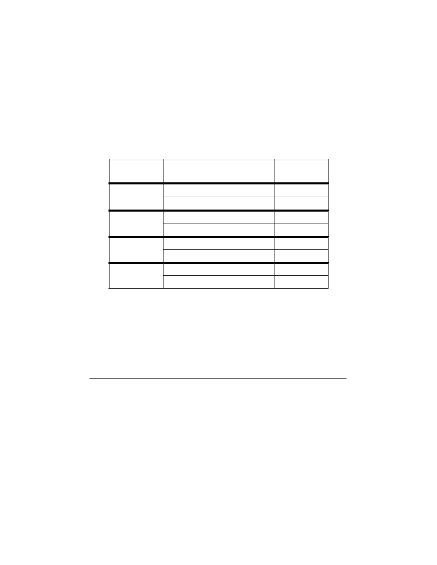
61 On the cross section in your answer booklet , place an X where the metamorphic rock
quartzite may be found. [ 1 ]
62 Identify by name the most abundant mineral in rock unit A . [ 1 ]
63 State one piece of evidence shown in the cross section that indicates that rock unit D
is older than igneous intrusion C . [ 1 ]
P.S./E. Sci.–Jan. ’07
[20]
Part C
Answer all questions in this part.
Directions (64–82): Record your answers in the spaces provided in your answer booklet. Some questions
may require the use of the Earth Science Reference Tables.
Base your answers to questions 64 and 65 on the data table below, which shows the azimuths of sunrise and
sunset on August 2 observed at four different latitudes. Azimuth is the compass direction measured, in degrees,
along the horizon, starting from north.
Data Table
Azimuths of Sunrise
Latitude
Letter Code
and Sunset
sunrise 69°
A
30° N
sunset 291°
B
sunrise 66°
C
40° N
sunset 294°
D
sunrise 61°
E
50° N
sunset 299°
F
sunrise 51°
G
60° N
sunset 309°
H
64 On the outer edge of the azimuth circle in your answer booklet , mark with an X the
positions of sunrise and sunset for each latitude shown in the data table. Write the
correct letter code beside each X . The positions of sunrise and sunset for 30° N have
been plotted and labeled with letters A and B . [ 2 ]
65 State the relationship at sunrise between the latitude and the azimuth. [ 1 ]
P.S./E. Sci.–Jan ’07
[21]
[OVER]
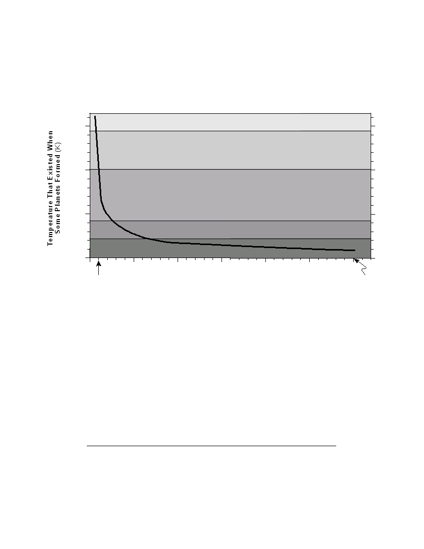
Base your answers to questions 66 through 69 on the graph below, which shows two conditions responsible
for the formation and composition of some planets in our solar system. The distances of Earth and Neptune
from the Sun, in astronomical units (AU), are shown beneath the horizontal axis. (1 AU = 149.6 million kilo-
meters). The plotted line on this graph shows the relationship between a planet’s distance from the Sun and the
inferred temperature at its formation. The regions within the graph indicate the composition of planets formed
within these zones.
Main Composition of Planets
Aluminum oxide
1,500
Iron
1,000
Silicates
500
Carbon-rich silicates
Frozen gases
0
0
5
10
15
20
25
30
Earth
Neptune
Distance from the Sun (AU)*
* 1 AU equals the average distance from Earth to the Sun or 149.6 million kilometers.
66 According to the graph, Neptune was mainly composed of which material at the time
of its formation? [ 1 ]
67 Saturn is located 9.5 AU from the Sun. State the approximate temperature at which
Saturn formed. [ 1 ]
68 State the relationship between a planet’s distance from the Sun and the temperature
at which that planet formed. [ 1 ]
69 What is Jupiter’s distance from the Sun, in astronomical units? Express your answer
to the nearest tenth . [ 1 ]
P.S./E. Sci.–Jan ’07
[22]
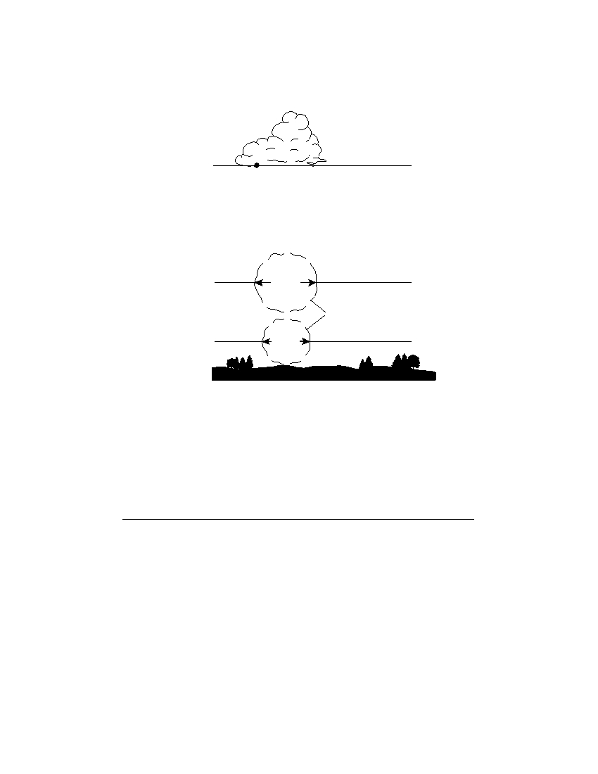
Base your answers to questions 70 through 72 on the diagram below, which shows the temperature change
when a parcel of air warms, rises, and expands to form a cloud. Location A is at the base of the cloud.
Cloud Formation
A
3350 feet
1350 feet
54.5 ° F
Parcels of air
350 feet
60.0 ° F
70 Explain why the warmer air rises. [ 1 ]
71 Assume the cooling rate of the rising parcel of air is constant. Determine the
temperature of the air parcel at the 3350-foot altitude. Express your answer to the
nearest tenth of a degree . [ 1 ]
72 State the relative humidity of the air at location A . [ 1 ]
P.S./E. Sci.–Jan ’07
[23]
[OVER]
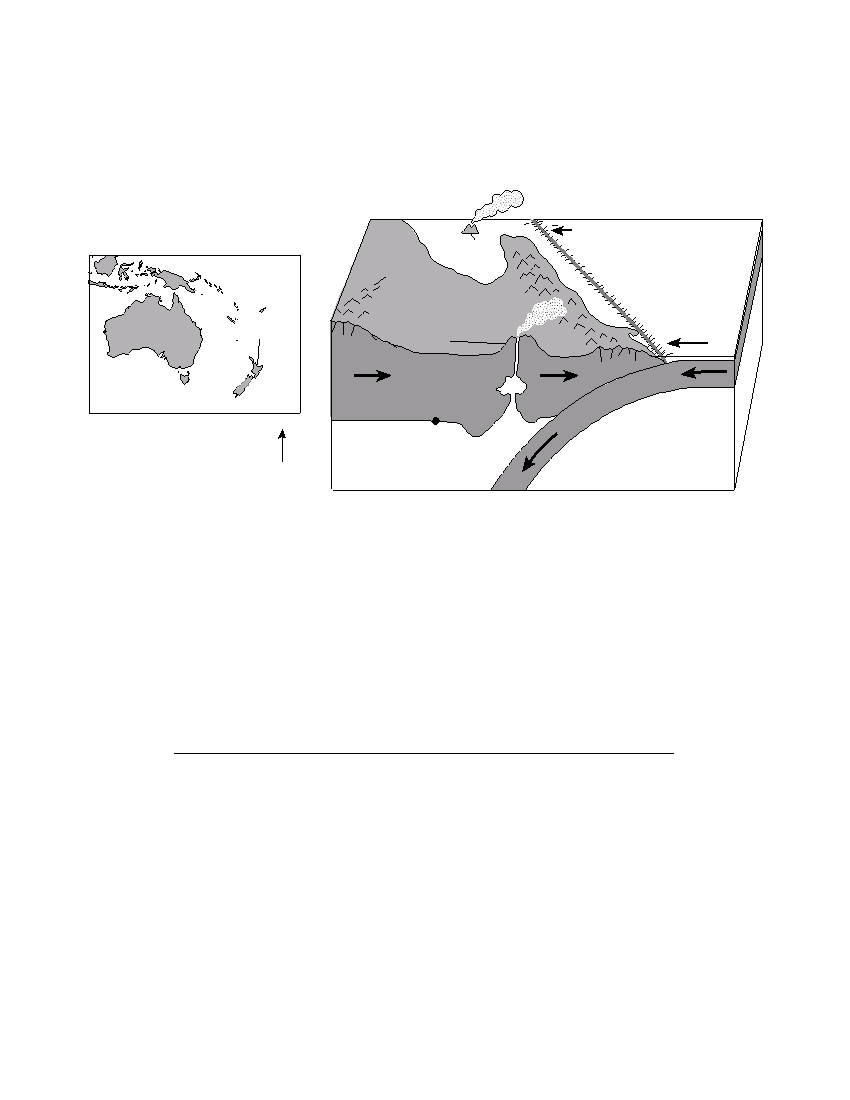
Base your answers to questions 73 through 76 on the map and block diagram below. The map shows the
location of North Island in New Zealand. The block diagram shows a portion of North Island. The Hikurangi
Trench is shown forming at the edge of the Pacific Plate. Point X is at the boundary between the lithosphere
and the asthenosphere.
Block Diagram
Map
White
Hikurangi
Island
Pacific Plate
North
Island
T
rench
Australia
North Island
Mt. Ruapehu
New
Zealand
Lithosphere
r e
p h
e
X
o s
L i t h
N
Asthenosphere
Asthenosphere
(Not drawn to scale)
73 State the approximate temperature at point X . [ 1 ]
74 On what tectonic plate are both North Island and White Island located? [ 1 ]
75 Describe the type of tectonic plate motion that formed the Hikurangi Trench. [ 1 ]
76 Describe one action that people on North Island should take if a tsunami warning is
issued. [ 1 ]
P.S./E. Sci.–Jan ’07
[24]

Base your answers to questions 77 through 79 on the data table below and on your knowledge of Earth
science. The data table shows the average monthly discharge, in cubic feet per second, for a stream in New
York State.
Data Table
Month
Jan
Feb
Mar
Apr
May
Jun
Jul
Aug
Sept
Oct
Nov
Dec
Discharge
48
52
59
66
62
70
72
59
55
42
47
53
(ft 3 /sec)
77 On the grid in your answer booklet , plot with an X the average stream discharge for
each month shown in the data table. Connect the X s with a line. [ 1 ]
78 State the relationship between this stream’s discharge and the amount of suspended
sediment that can be carried by this stream. [ 1 ]
79 Explain one possible reason why this stream’s discharge in April is usually greater than
this stream’s discharge in January. [ 1 ]
Base your answers to questions 80 through 82 on the passage below and on your knowledge of Earth
science.
Ozone in Earth’s Atmosphere
Ozone is a special form of oxygen. Unlike the oxygen we breathe, which is composed
of two atoms of oxygen, ozone is composed of three atoms of oxygen. A concentrated
ozone layer between 10 and 30 miles above Earth’s surface absorbs some of the harmful
ultraviolet radiation coming from the Sun. The amount of ultraviolet light reaching
Earth’s surface is directly related to the angle of incoming solar radiation. The greater the
Sun’s angle of insolation, the greater the amount of ultraviolet light that reaches Earth’s
surface. If the ozone layer were completely destroyed, the ultraviolet light reaching
Earth’s surface would most likely increase human health problems, such as skin cancer
and eye damage.
80 State the name of the temperature zone of Earth’s atmosphere where the
concentrated layer of ozone gas exists. [ 1 ]
81 Explain how the concentrated ozone layer above Earth’s surface is beneficial to
humans. [ 1 ]
82 Assuming clear atmospheric conditions, on what day of the year do people in New
York State most likely receive the most ultraviolet radiation from the Sun? [ 1 ]
P.S./E. Sci.–Jan ’07
[25]

The University of the State of New York
R EGENTS H IGH S CHOOL E XAMINATION
PHYSICAL SETTING
EARTH SCIENCE
Wednesday, January 24, 2007 — 9:15 a.m. to 12:15 p.m., only
ANSWER SHEET
Student . . . . . . . . . . . . . . . . . . . . . . . . . . . . . . . . . . . . . . . . . . . . . . .
Sex:
I Male I Female
Grade . . . . . . . . . . . .
Teacher . . . . . . . . . . . . . . . . . . . . . . . . . . . . . . . . . . . . . . . . . . . . . . .
School . . . . . . . . . . . . . . . . . . . . . . . . . . . . . . . . . . . .
Record your answers to Part A and Part B–1 on this answer sheet.
Part A
Part B–1
1 . . . . . . . . . . . .
13 . . . . . . . . . . . .
25 . . . . . . . . . . .
36 . . . . . . . . . . . .
44 . . . . . . . . . . . .
2 . . . . . . . . . . . .
14 . . . . . . . . . . . .
26 . . . . . . . . . . .
37 . . . . . . . . . . . .
45 . . . . . . . . . . . .
3 . . . . . . . . . . . .
15 . . . . . . . . . . . .
27 . . . . . . . . . . .
38 . . . . . . . . . . . .
46 . . . . . . . . . . . .
4 . . . . . . . . . . . .
16 . . . . . . . . . . . .
28 . . . . . . . . . . .
39 . . . . . . . . . . . .
47 . . . . . . . . . . . .
5 . . . . . . . . . . . .
17 . . . . . . . . . . . .
29 . . . . . . . . . . .
40 . . . . . . . . . . . .
48 . . . . . . . . . . . .
6 . . . . . . . . . . . .
18 . . . . . . . . . . . .
30 . . . . . . . . . . .
41 . . . . . . . . . . . .
49 . . . . . . . . . . . .
7 . . . . . . . . . . . .
19 . . . . . . . . . . . .
31 . . . . . . . . . . .
42 . . . . . . . . . . . .
50 . . . . . . . . . . . .
Part B–1 Score
8 . . . . . . . . . . . .
20 . . . . . . . . . . . .
32 . . . . . . . . . . .
43 . . . . . . . . . . . .
9 . . . . . . . . . . . .
21 . . . . . . . . . . . .
33 . . . . . . . . . . .
10 . . . . . . . . . . . .
22 . . . . . . . . . . . .
34 . . . . . . . . . . .
11 . . . . . . . . . . . .
23 . . . . . . . . . . . .
35 . . . . . . . . . . .
Part A Score
12 . . . . . . . . . . . .
24 . . . . . . . . . . . .
Write your answers to Part B–2 and Part C in your answer booklet.
The declaration below should be signed when you have completed the examination.
I do hereby affirm, at the close of this examination, that I had no unlawful knowledge of the questions or answers prior to
the examination and that I have neither given nor received assistance in answering any of the questions during the examination.
Signature

PS/EARTH SCIENCE
E C N E I C S H T R A E / S P