
PS/EARTH SCIENCE
The University of the State of New York
REGENTS HIGH SCHOOL EXAMINATION
PHYSICAL SETTING
EARTH SCIENCE
Wednesday, January 23, 2008 — 9:15 a.m. to 12:15 p.m., only
This is a test of your knowledge of Earth science. Use that knowledge to answer
all questions in this examination. Some questions may require the use of the Earth
Science Reference Tables. The Earth Science Reference Tables are supplied separately.
Be certain you have a copy of the 2001 Edition (Revised November 2006) of these
reference tables before you begin the examination.
Your answer sheet for Part A and Part B–1 is the last page of this examination
booklet. Turn to the last page and fold it along the perforations. Then, slowly and
carefully, tear off your answer sheet and fill in the heading.
The answers to the questions in Part B–2 and Part C are to be written in your
separate answer booklet. Be sure to fill in the heading on the front of your answer
booklet.
You are to answer all questions in all parts of this examination according to the
directions provided in the examination booklet. Record your answers to the Part A
and Part B–1 multiple-choice questions on your separate answer sheet. Write your
answers to the Part B–2 and Part C questions in your answer booklet. All work should
be written in pen, except for graphs and drawings, which should be done in pencil.
You may use scrap paper to work out the answers to the questions, but be sure to
record all your answers on your separate answer sheet and in your answer booklet.
When you have completed the examination, you must sign the statement printed
at the end of your separate answer sheet, indicating that you had no unlawful
knowledge of the questions or answers prior to the examination and that you have
neither given nor received assistance in answering any of the questions during the
examination. Your answer sheet and answer booklet cannot be accepted if you fail to
sign this declaration.
Notice. . .
A four-function or scientific calculator and a copy of the 2001 Earth Science Reference Tables
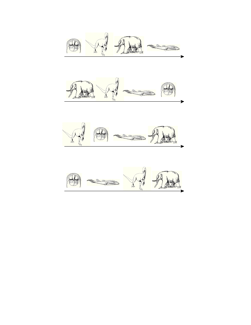
(Revised November 2006) must be available for you to use while taking this examination.
The use of any communications device is strictly prohibited when taking this
examination. If you use any communications device, no matter how briefly, your
examination will be invalidated and no score will be calculated for you.
DO NOT OPEN THIS EXAMINATION BOOKLET UNTIL THE SIGNAL IS GIVEN.
E C N E I C S H T R A E / S P

Part A
Answer all questions in this part.
Directions (1–35): For each statement or question, write on your separate answer sheet the number of the
word or expression that, of those given, best completes the statement or answers the question. Some questions
may require the use of the Earth Science Reference Tables .
1 One factor responsible for the strength of
6 What causes the Coriolis effect?
gravitational attraction between a planet and the
(1) Earth’s tilt on its axis
Sun is the
(2) the spin of Earth on its axis
(1) degree of tilt of the planet’s axis
(3) the orbital motion of the Moon around Earth
(2) distance between the planet and the Sun
(4) the orbital motion of Earth around the Sun
(3) planet’s period of rotation
(4) amount of insolation given off by the Sun
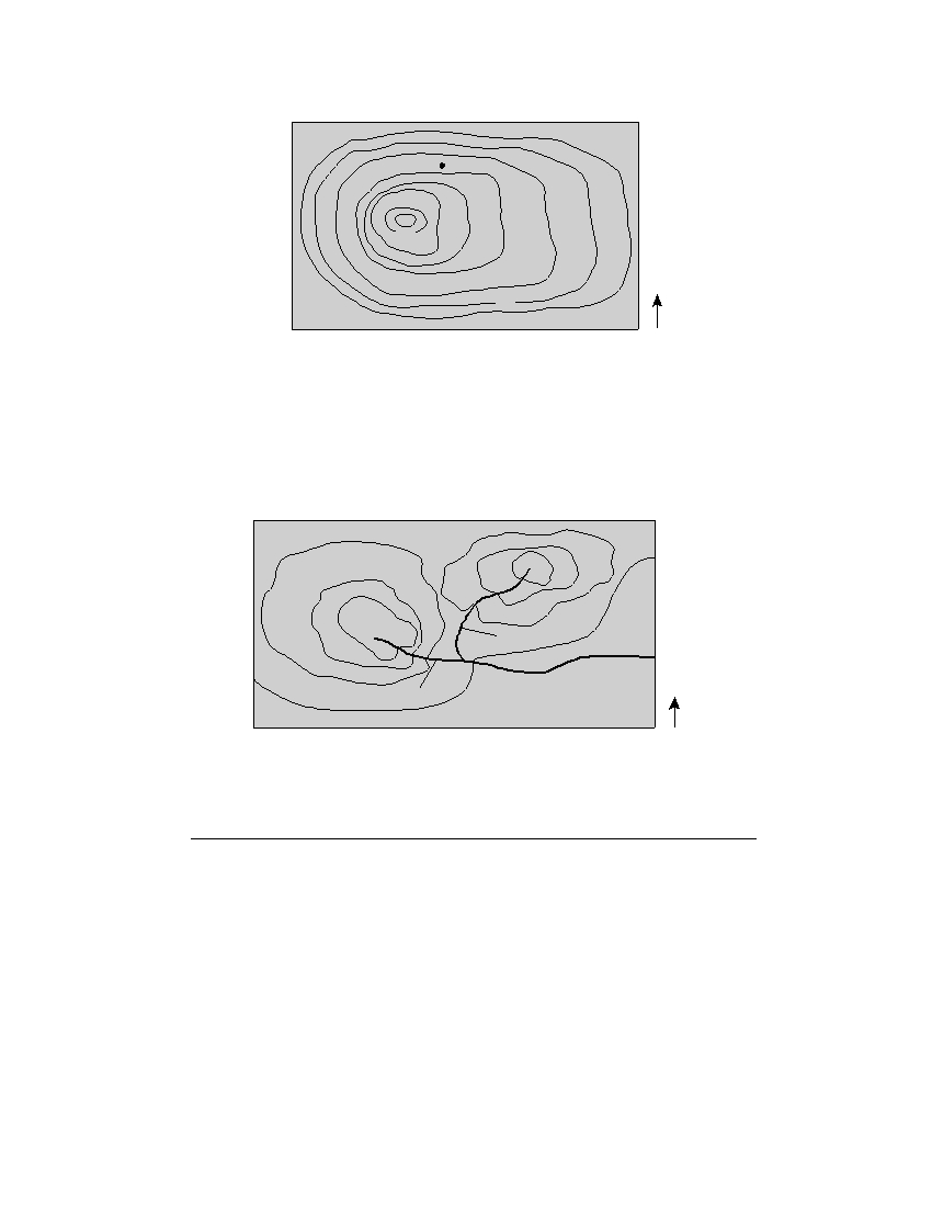
7 What is the relative humidity when the dry-bulb
temperature is 16°C and the wet-bulb tempera-
2 Which planet is located approximately ten times
ture is 14°C?
farther from the Sun than Earth is from the Sun?
(1) 90%
(3) 14%
(1) Mars
(3) Saturn
(2) 80%
(4) 13%
(2) Jupiter
(4) Uranus
8 Which weather instrument is used to measure
3 Large craters found on Earth support the
wind speed?
hypothesis that impact events have caused
(1) anemometer
(3) psychrometer
(1) a decrease in the number of earthquakes and
(2) wind vane
(4) thermometer
an increase in sea level
(2) an increase in solar radiation and a decrease
in Earth radiation
9 A weather station model is shown below.
(3) the red shift of light from distant stars and the
blue shift of light from nearby stars
029
(4) mass extinctions of life-forms and global
climate changes
4 What is the inferred age of our solar system, in
What is the barometric pressure indicated by this
millions of years?
station model?
(1) 544
(3) 4600
(1) 0.029 mb
(3) 1002.9 mb
(2) 1300
(4) 10,000
(2) 902.9 mb
(4) 1029.0 mb
5 The water table usually rises when there is
10 The upward movement of air in the atmosphere
generally causes the temperature of that air to
(1) a decrease in the amount of infiltration
(2) a decrease in the amount of surface area
(1) decrease and become closer to the dewpoint
covered by vegetation
(2) decrease and become farther from the
(3) an increase in the amount of precipitation
dewpoint
(4) an increase in the slope of the land
(3) increase and become closer to the dewpoint
(4) increase and become farther from the dewpoint
P.S./E. Sci.–Jan. ’08
[2]
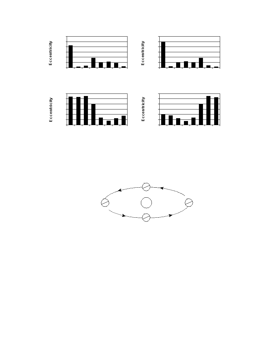
11 Which bar graph correctly shows the orbital eccentricity of the planets in our solar system?
0.300
0.300
0.250
0.250
0.200
0.200
0.150
0.150
0.100
0.100
0.050
0.050
0
0
M
V
E
M
J
S
U
N
M
V
E
M
J
S
U
N
Planets
Planets
( 1 )
( 3 )
0.300
0.300
0.250
0.250
0.200
0.200
0.150
0.150
0.100
0.100
0.050
0.050
0
0
M
V
E
M
J
S
U
N
M
V
E
M
J
S
U
N
Planets
Planets
( 2 )
( 4 )
12 The diagram below shows Earth in its orbit around the Sun. Positions A, B, C, and D represent Earth at
the beginning of each season.
Position D
N
S
N
N
Position A
Sun
Position C
S
S
N
S
Position B
(Not drawn to scale)
At which lettered position of Earth does New York State experience the first day
of summer?
(1) A
(3) C
(2) B
(4) D
P.S./E. Sci.–Jan. ’08
[3]
[OVER]
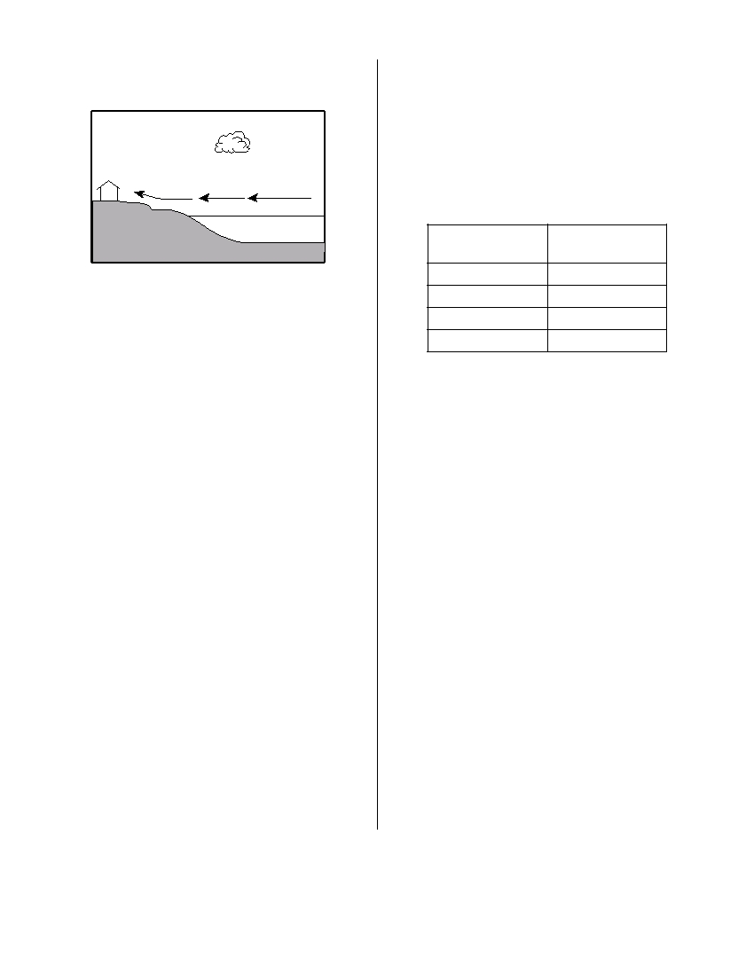
13 The cross section below shows a house on the
17 Which ocean current transports warm water away
shore of Lake Ontario in August.
from Earth’s equatorial region?
(1) Brazil Current
(3) Falkland Current
(2) Guinea Current
(4) California Current
18 The data table below shows the density of four
Wind
different mineral samples.
Data Table
Lake Ontario
Mineral
Density
(g/cm 3 )
(Not drawn to scale)
corundum
4.0
galena
7.6
Under which conditions would the wind shown in
hematite
5.3
the cross section most likely occur?
quartz
2.7
(1) at 2 a.m., when the air over land is 70°F and
the air over the lake is 80°F
(2) at 6 a.m., when the air over land is 70°F and
A student accurately measured the mass of a
the air over the lake is 70°F
sample of one of the four minerals to be
(3) at 2 p.m., when the air over land is 80°F and
294.4 grams and its volume to be 73.6 cm 3 .
the air over the lake is 70°F
Which mineral sample did the student measure?
(4) at 10 p.m., when the air over land is 70°F and
(1) corundum
(3) hematite
the air over the lake is 72°F
(2) galena
(4) quartz
14 Which type of surface absorbs the greatest
19 Which mineral has a metallic luster, a black
amount of electromagnetic energy from the Sun?
streak, and is an ore of iron?
(1) smooth, shiny, and light colored
(1) galena
(3) pyroxene
(2) smooth, shiny, and dark colored
(2) magnetite
(4) graphite
(3) rough, dull, and light colored
(4) rough, dull, and dark colored
20 The edges of most lithospheric plates are
characterized by
15 Which New York State location is most likely to
experience the heaviest winter snowfall when the
(1) reversed magnetic orientation
surface winds are blowing from the west or north-
(2) unusually rapid radioactive decay
west?
(3) frequent volcanic activity
(4) low P -wave and high S -wave velocity
(1) New York City
(3) Oswego
(2) Binghamton
(4) Plattsburgh
21 Compared to Earth’s continental crust, Earth’s
oceanic crust is
16 The largest particles that a stream deposits as it
enters a pond are 8 centimeters in diameter. The
(1) thinner and more dense
minimum velocity of the stream is approximately
(2) thinner and less dense
(3) thicker and more dense
(1) 100 cm/sec
(3) 300 cm/sec
(4) thicker and less dense
(2) 200 cm/sec
(4) 400 cm/sec
P.S./E. Sci.–Jan. ’08
[4]
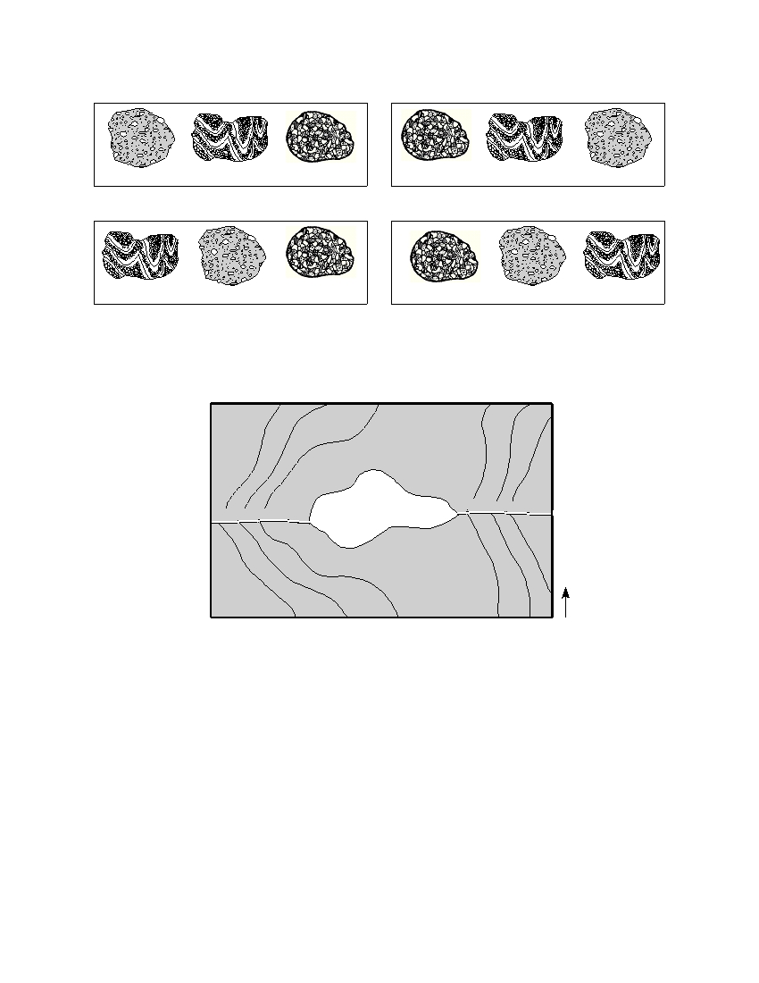
22 In which set are the rock drawings labeled with their correct rock types?
Igneous
Sedimentary Metamorphic
Igneous
Sedimentary Metamorphic
( 1 )
( 3 )
Igneous
Sedimentary Metamorphic
Igneous
Sedimentary Metamorphic
( 2 )
( 4 )
23 The topographic map below shows a lake and two rivers.
Sapphire River
Gem
Garnet River
Lake
N
In which direction does each of the rivers flow?
(1) The Sapphire River and the Garnet River both flow east.
(2) The Sapphire River and the Garnet River both flow west.
(3) The Sapphire River flows east and the Garnet River flows west.
(4) The Sapphire River flows west and the Garnet River flows east.
P.S./E. Sci.–Jan. ’08
[5]
[OVER]
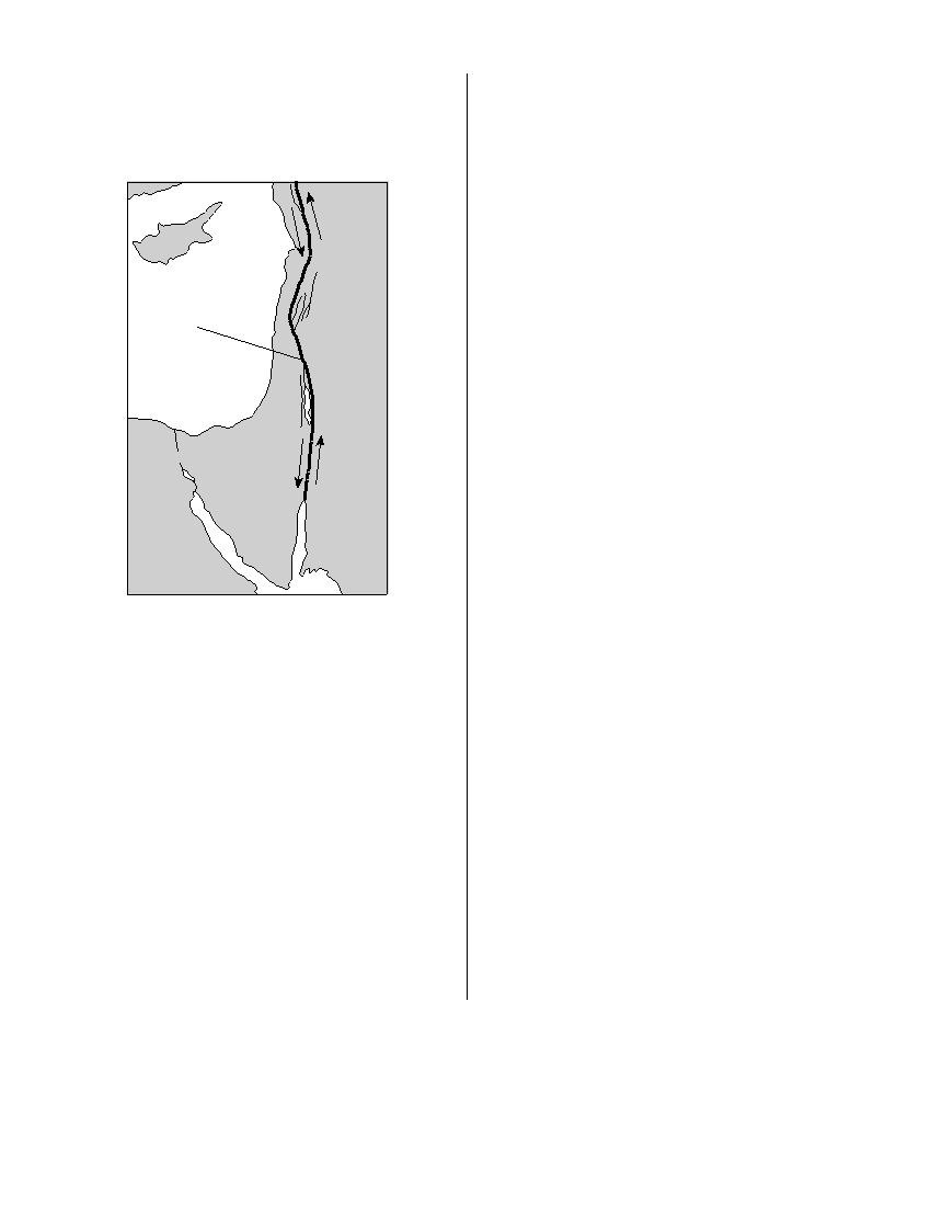
24 The map below shows the northern section of the
27 Which statement correctly compares seismic
boundary between the Arabian Plate and the
P -waves with seismic S -waves?
African Plate. Arrows show the relative direction
(1) P -waves travel faster than S -waves and pass
of plate motion.
through Earth’s liquid zones.
(2) P -waves travel faster than S -waves and do not
pass through Earth’s liquid zones.
(3) P -waves travel slower than S -waves and pass
through Earth’s liquid zones.
(4) P -waves travel slower than S -waves and do
not pass through Earth’s liquid zones.
Jordan
28 What is the geologic age sequence of the surface
Fault
Arabian
bedrock from Ithaca, New York, to Watertown,
Plate
New York?
(1) Ordovician, Taconic, Cambrian
(2) Ordovician, Tertiary, Pleistocene
(3) Devonian, Silurian, Cambrian
(4) Devonian, Silurian, Ordovician
African Plate
29 A whalebone that originally contained 200 grams
of
radioactive
carbon-14
now
contains
25 grams of carbon-14. How many carbon-14
half-lives have passed since this whale was alive?
(1) 1
(3) 3
(2) 2
(4) 4
Which type of plate boundary is located at the
30 Which geologic event occurred during the same
Jordan Fault?
geologic period as the first appearance of modern
(1) divergent
(3) convergent
corals in Earth’s oceans?
(2) subduction
(4) transform
(1) Grenville Orogeny
(2) Acadian Orogeny
25 A seismograph station recorded the arrival of
(3) intrusion of the Palisades Sill
the first P -wave at 7:32 p.m. from an earthquake
(4) formation of the Catskill Delta
that occurred 4000 kilometers away. What time
was it at the station when the earthquake
31 The presence of eurypterid fossils in New York
occurred?
State bedrock indicates that
(1) 7:20 p.m.
(3) 7:32 p.m.
(1) eurypterids lived in land environments
(2) 7:25 p.m.
(4) 7:39 p.m.
(2) eurypterids first appeared on Earth during
the Devonian Period
26 Which temperature is inferred to exist in Earth’s
(3) most of New York State was once a moun-
plastic mantle?
tainous region
(1) 2000°C
(3) 5000°C
(4) areas of New York State were once covered
(2) 3000°C
(4) 6000°C
with shallow seas
P.S./E. Sci.–Jan. ’08
[6]
32 Which sequence of New York State index fossils shows the order in which the organisms appeared on Earth?
Oldest
Youngest
Time
( 1 )
Oldest
Youngest
Time
( 2 )
Oldest
Youngest
Time
( 3 )
Oldest
Youngest
Time
( 4 )
33 The generalized landscape regions of New York State are classified according to
(1) bedrock structure and elevation
(3) latitude and longitude
(2) bedrock type and index fossils
(4) climate and topography
P.S./E. Sci.–Jan. ’08
[7]
[OVER]
34 Point X is a location on the topographic map below. Elevations are measured in meters.
X
75
N
50
What is a possible elevation, in meters, of point X ?
(1) 55
(3) 68
(2) 57
(4) 70
35 The topographic map below shows two hills labeled A and B . The tributary streams labeled X and Y have
the same volume of water.
B
A
X
Stream
Y
N
Which statement is best supported by the map?
(1) Hill A is higher than hill B .
(3) Stream X flows faster than stream Y .
(2) Hill B is higher than hill A .
(4) Stream Y flows faster than stream X.
P.S./E. Sci.–Jan. ’08
[8]
Part B–1
Answer all questions in this part.
Directions (36–50): For each statement or question, write on your separate answer sheet the number of the
word or expression that, of those given, best completes the statement or answers the question. Some questions
may require the use of the Earth Science Reference Tables .
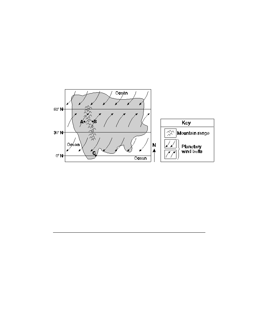
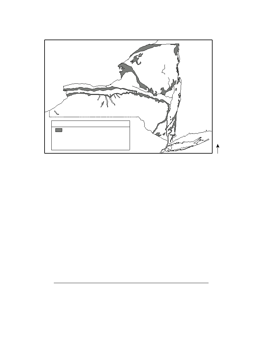
Base your answers to questions 36 and 37 on the map below, which represents an imaginary continent.
Locations A and B are on opposite sides of a mountain range on a planet similar to Earth. Location C is on the
planet’s equator.
36 Compared to the climate at location A , the climate at location B would most likely be
(1) warmer and more humid
(3) cooler and more humid
(2) warmer and less humid
(4) cooler and less humid
37 Location C most likely experiences
(1) low air pressure and low precipitation
(2) low air pressure and high precipitation
(3) high air pressure and low precipitation
(4) high air pressure and high precipitation
P.S./E. Sci.–Jan. ’08
[9]
[OVER]
Base your answers to questions 38 through 40 on the flowchart below, which shows a general overview of
the processes and substances involved in the weathering of rocks at Earth’s surface. Letter X represents an
important substance involved in both major types of weathering, labeled A and B on the flowchart. Some
weathering processes are defined below the flowchart.
Weathering
one major type is
one major type is
A
B
involves
caused by
caused by
Substance
Impacts with
Expansion
X
other minerals
combines with
of
of
Atmospheric
Substance
gases
causing
Rock
X
causing
causing
causing
causing
Hydrolysis
Carbonation
Abrasion
Frost action
Exfoliation
Definitions
Frost action – the breakup of rocks caused by the expansion of substance X
Abrasion – the wearing down of rocks or particles as they rub or bounce against other rocks
Exfoliation – the peeling away of large sheets of loosened material at the surface of a rock
Hydrolysis – the change in a material caused by contact with substance X
Carbonation – the change in a material caused by contact with carbonic acid
38 Which term best identifies the type of weathering represented by A ?
(1) physical
(3) chemical
(2) biological
(4) glacial
39 Which substance is represented by X on both sides of the flowchart?
(1) potassium feldspar
(3) hydrochloric acid
(2) air
(4) water
40 Which weathering process is most common in a hot, dry environment?
(1) abrasion
(3) frost action
(2) carbonation
(4) hydrolysis
P.S./E. Sci.–Jan. ’08
[10]
Base your answers to questions 41 through 44 on the map below, which shows areas where certain
minerals were mined in significant amounts during 1989.
Mineral Resources of New York State
T
Wo
Wo
Gt
G
Cl
S
S
S
S
S
Cl
Cl
Cl
Key
Cl
limestone or dolostone
Cl
clay (shale)
S
salt (halite)
G
gypsum
T
talc
N
Gt
garnet
Wo wollastonite
41 In which New York State landscape region was most of the garnet mined?
(1) Catskills
(3) Tug Hill Plateau
(2) Adirondack Mountains
(4) Erie-Ontario Lowlands
42 What is a common use for the mineral that is mined at the southern end of the two
largest Finger Lakes?
(1) making talcum powder
(3) polishing jewelry
(2) vulcanizing rubber
(4) melting ice
43 The gypsum deposits in New York State were formed
(1) as a result of volcanic eruptions
(3) in a shallow ocean
(2) as a result of metamorphism
(4) in a glacial outwash plain
44 The mineral wollastonite has a hardness of 4.5 to 5. Which New York State mineral
could easily scratch wollastonite?
(1) garnet
(3) talc
(2) halite
(4) gypsum
P.S./E. Sci.–Jan. ’08
[11]
[OVER]
Base your answers to questions 45 and 46 on the cross section below, which shows an underwater
mountain range in the Atlantic Ocean. The oceanic bedrock is composed mainly of basalt. Points X and Y are
locations in the bedrock that have been diverging at the same rate. The movement of the North American Plate
and Eurasian Plate is shown by the two arrows.
Atlantic Ocean
X
Y
P l a t e
E u r a s i a n P l a t e
N o r t h A m e r i c a n
( Not drawn to scale)
45 Which statements best describe the age and magnetic orientation of the basalts found
at locations X and Y ?
(1) The basalt at location X is younger than the basalt at location Y . Both
locations have the same magnetic orientation.
(2) The basalts at locations X and Y are the same age. Both locations have the
same magnetic orientation.
(3) The basalts at locations X and Y are the same age. Location X has normal
magnetic orientation and location Y has reversed magnetic orientation.
(4) The basalt at location X is older than the basalt at location Y . Location X has
reversed magnetic orientation and location Y ha s normal magnetic orientation.
P.S./E. Sci.–Jan. ’08
[12]
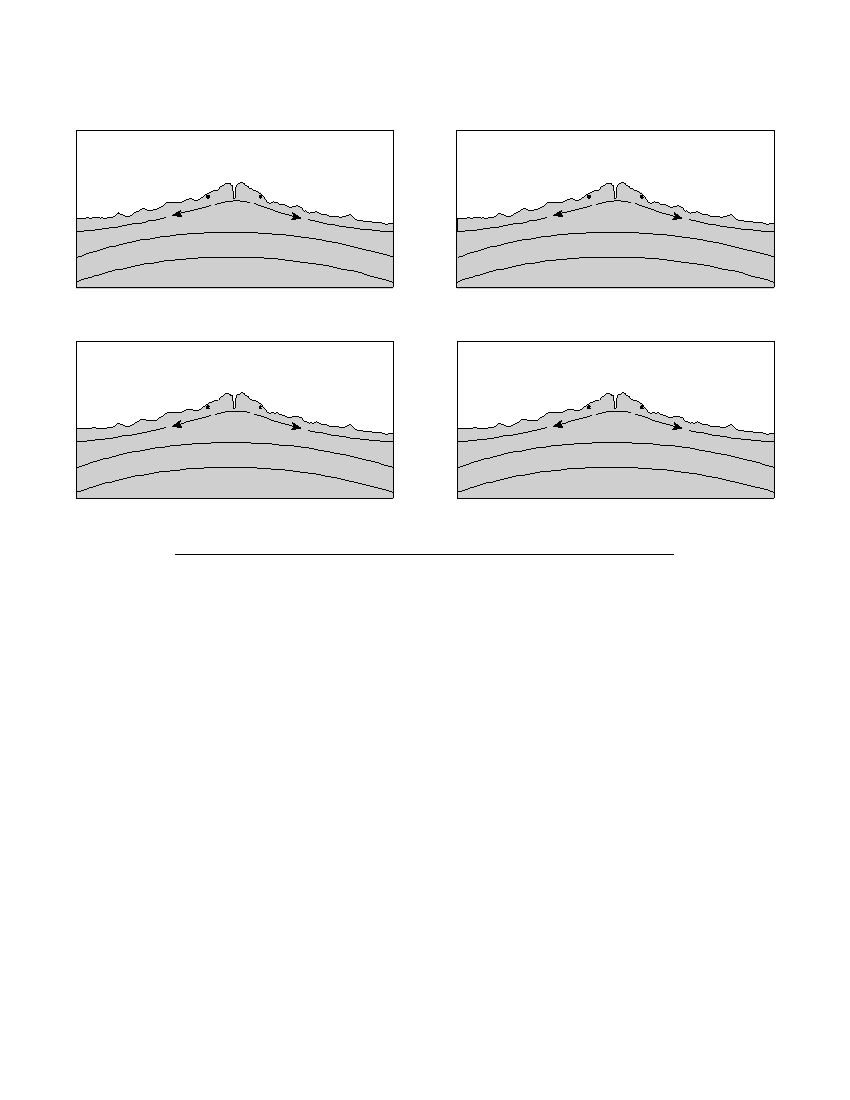
46 Which cross section best represents the relative locations of Earth’s asthenosphere,
rigid mantle, and stiffer mantle? (The cross sections are not drawn to scale.)
Atlantic Ocean
Atlantic Ocean
X
Y
X
Y
P l a t e
E u r a s i a n P l a t e
P l a t e
E u r a s i a n P l a t e
N o r t h A m e r i c a n
N o r t h A m e r i c a n
R i g i d m a n t l e
A s t h e nos p h e r e
A s t h e nos p h e r e
R i g i d m a n t l e
S t i f f e r m a n t l e
S t i f f e r m a n t l e
( 1 )
( 3 )
Atlantic Ocean
Atlantic Ocean
X
Y
X
Y
P l a t e
E u r a s i a n P l at e
P l a t e
E u r a s i a n P l at e
N o r t h A m e r i c a n
N o r t h A m e r i c a n
S t i f f e r m a n t l e
R i g i d m a n t l e
A s t h e nos p h e r e
S t i f f e r m a n t l e
R i g i d m a n t l e
A s t h e nos p h e r e
( 2 )
( 4 )
P.S./E. Sci.–Jan. ’08
[13]
[OVER]
Base your answers to questions 47 through 50 on the diagram below, which represents the Sun’s apparent
paths and the solar noon positions for an observer at 42° N latitude on December 21, September 23, and
June 21.
Solar noon
Solar noon
Sun’s
June
apparent
path
Solar noon
September
21
December
23
W
21
S
N
Observer
E
47 In which direction will sunrise occur on June 21?
(1) north of due west
(3) south of due west
(2) north of due east
(4) south of due east
48 How many hours occurred between sunrise and solar noon on September 23?
(1) 6
(3) 12
(2) 8
(4) 24
49 Which diagram best shows the location of Polaris relative to the observer?
Polaris
W
Polaris
W
S
Observer
N
S
Observer
N
E
E
( 1 1 ) )
( ( 3 3 ) )
Polaris
Polaris
W
W
S
Observer
N
S
Observer
N
E
E
( 2 2 ) )
( ( 4 4 ) )
P.S./E. Sci.–Jan. ’08
[14]
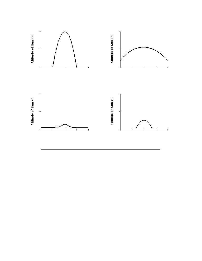
50 Which graph best shows the altitude of the Sun, as measured by the observer located
at 42° N, at various times on December 21?
90
90
45
45
0
0
12 a.m.
6 a.m.
noon
6 p.m.
midnight
12 a.m.
6 a.m.
noon
6 p.m.
midnight
Time on December 21
Time on December 21
( 1 )
( 3 )
90
90
45
45
0
0
12 a.m.
6 a.m.
noon
6 p.m.
midnight
12 a.m.
6 a.m.
noon
6 p.m.
midnight
Time on December 21
Time on December 21
( 2 )
( 4 )
P.S./E. Sci.–Jan. ’08
[15]
[OVER]
Part B–2
Answer all questions in this part.
Directions (51–65): Record your answers in the spaces provided in your answer booklet. Some questions
may require the use of the Earth Science Reference Tables.
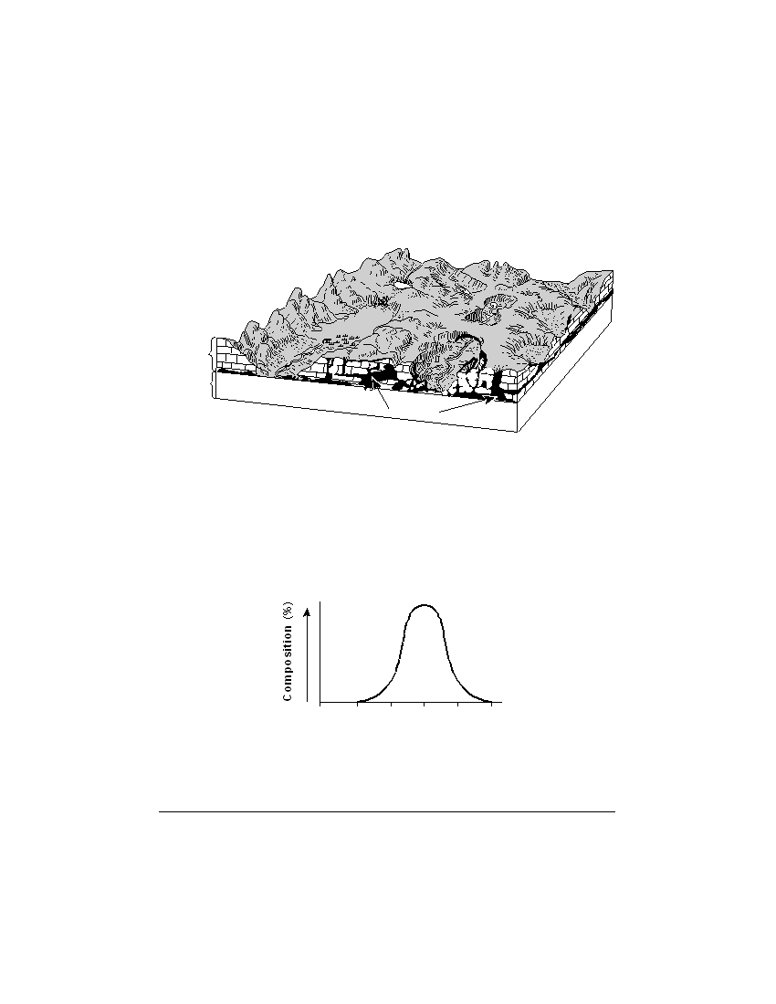
Base your answers to questions 51 through 53 on the block diagram below, which shows the landscape
features of an area of Earth’s crust. Two sedimentary rock layers, A and B , are labeled in the diagram. The rock
symbol for layer B has been omitted.
Layer A
Layer B
Cavern
51 Identify the most abundant mineral in rock layer A . [1]
52 Describe how the caverns formed in rock layer A . [1]
53 The graph below shows the particle sizes that compose the clastic sedimentary rock
in layer B .
0
0.02 0.04 0.06 0.08 0.10
Particle Diameter (cm)
In the box in your answer booklet, draw the map symbol from the Earth Science
Reference Tables that represents rock layer B . [1]
P.S./E. Sci.–Jan. ’08
[16]
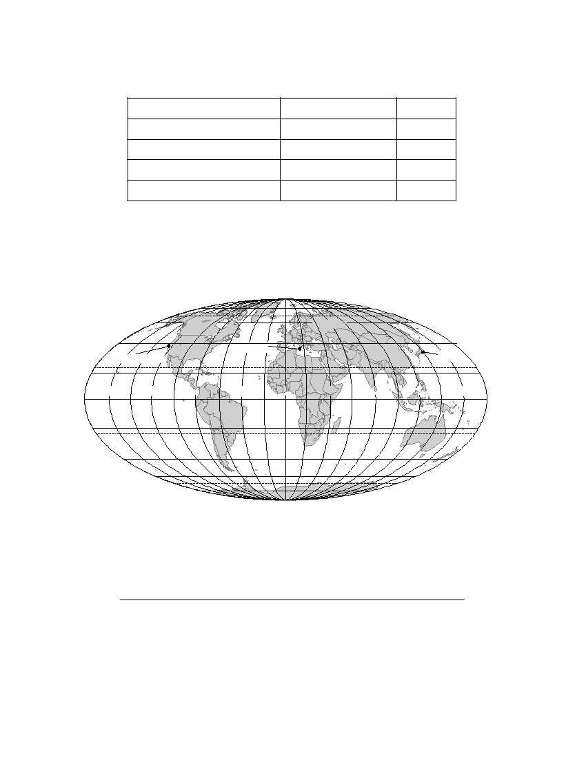
Base your answers to questions 54 through 56 on the table below, which lists the location of some
earthquakes, their Richter magnitude, and their year of occurrence.
Data Table
Location
Richter Magnitude
Year
San Francisco, United States
7.8
1906
Messina, Italy
7.5
1908
Tokyo, Japan
8.3
1923
San Francisco, United States
7.1
1989
54 What data do scientists use to determine the magnitude of earthquakes without
visiting the actual sites? [1]
55 The locations of the earthquakes listed in the table are shown on the map below.
80°
80°
60°
60°
40°
Messina
40°
San Francisco
Tokyo
20°
20°
160°
120°
80°
40°
0°
40°
80°
120°
160°
0°
0°
20°
20°
40°
40°
60°
60°
80°
80°
Explain how the locations of these earthquakes are related to tectonic plates. [1]
56 Identify the process in Earth’s asthenosphere that is inferred to be the cause of
tectonic plate motion. [1]
P.S./E. Sci.–Jan. ’08
[17]
[OVER]
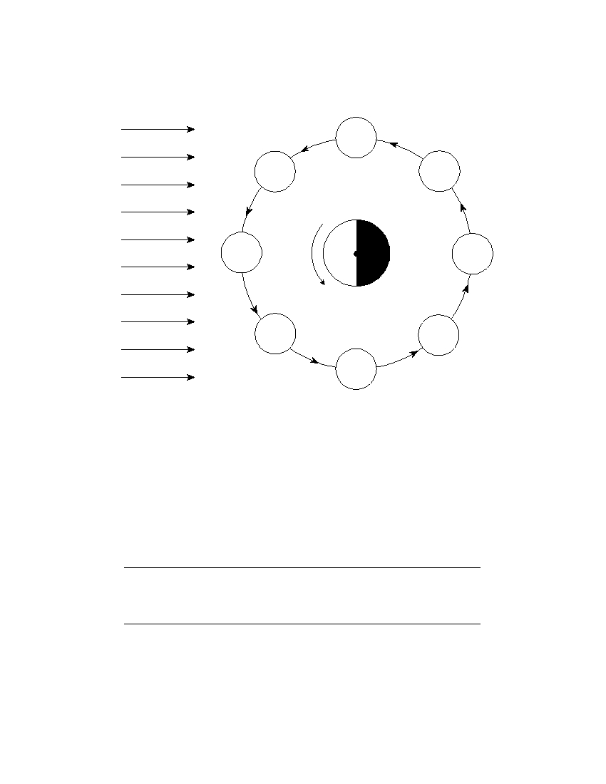
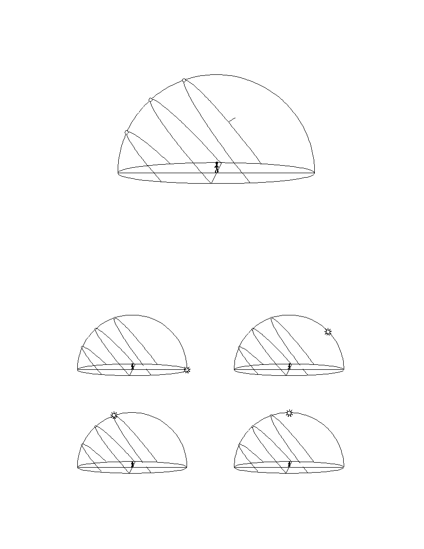
Base your answers to questions 57 through 60 on the diagram below, which shows Earth as viewed from
above the North Pole. The nighttime side of Earth has been shaded. The Moon is shown at eight positions in
its orbit around Earth. The name of each Moon phase is indicated at each Moon position. The dark portion of
each Moon position has not been shaded.
Last
quarter
Old
Old
crescent
gibbous
Sun’s
rays
New
North
Full
Moon
Pole
Moon
New
New
crescent
gibbous
First
quarter
(Not drawn to scale)
57 On the diagram in your answer booklet, shade the portion of the Moon that is in
darkness to show the last quarter phase as viewed from New York State. [1]
58 Explain what causes the Moon’s phases when viewed from Earth. [1]
59 Which Moon phase occurs approximately one week after the New Moon phase? [1]
60 Explain why the same side of the Moon always faces Earth. [1]
61 Complete the table in your answer booklet by identifying the color and classification
of the star Procyon B. The data for the Sun have been completed as an example. [1]
P.S./E. Sci.–Jan. ’08
[18]

Base your answers to questions 62 through 65 on the cross section in your answer booklet which shows a
portion of Earth’s crust. Letters A through J represent rock units or geologic structures. The rock units have
not been overturned.
62 On the cross section in your answer booklet, draw a circle around the letter of the
oldest rock unit shown. [1]
63 On the same cross section, place an X to indicate a location where the rock, marble,
was formed. [1]
64 Describe one piece of evidence shown in the cross section that suggests rock unit D
is younger than rock unit F . [1]
65 Explain why rock unit H is not one continuous layer. [1]
P.S./E. Sci.–Jan. ’08
[19]
[OVER]

Part C
Answer all questions in this part.
Directions (66–84): Record your answers in the spaces provided in your answer booklet. Some questions
may require the use of the Earth Science Reference Tables.
Base your answers to questions 66 through 70 on the weather map in your answer booklet. The isobars show
air pressures, in millibars. Points A and B indicate locations on the map.
66 On the weather map in your answer booklet, place an X centered on the geographic
region that was most likely the source of the mT air mass. [1]
67 Calculate the pressure gradient along a straight line between point A and point B on
the map. Label your answer with the correct units. [2]
68 Describe the evidence shown on the map that indicates strong winds were blowing
between Miles City and Pierre. [1]
69 In the table in your answer booklet, write the names of the cities listed below in
sequence from lowest relative humidity to highest relative humidity. [1]
Albuquerque
Chicago
New York City
70 Describe the pattern of the surface winds around the center of the low-pressure
system ( L ). [1]
P.S./E. Sci.–Jan. ’08
[20]
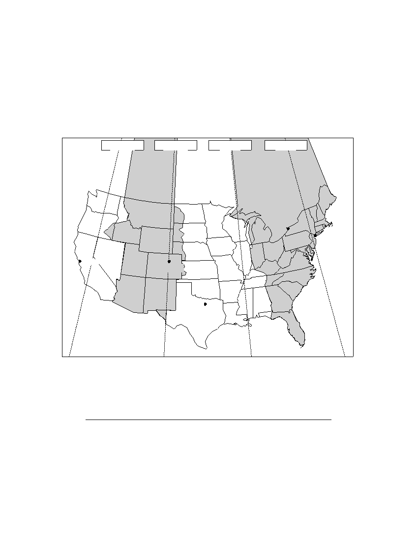
Base your answers to questions 71 and 72 on the passage and time zones map shown below.
Time Zones
In 1883, Earth was divided into 24 time zones. The United States (excluding Alaska
and Hawaii) has four time zones, which are indicated by different shadings on the map.
Each zone is roughly centered on lines of longitude that are 15° apart. These lines are
shown as dashed lines on the map. Most locations within a time zone have the same time.
This time is called standard time. As you move to the west, the time in each zone is one
hour earlier than the previous time zone.
120° W
105° W
90° W
75° W
Pacific
Mountain
Central
Eastern
time zone
time zone
time zone
time zone
Buffalo
New York
City
San Francisco
Denver
Dallas
71 When it is 1 a.m. in New York City, what time is it in Denver? [1]
72 Explain, in terms of Earth’s rotation, why the time zones are 15° of longitude apart. [1]
P.S./E. Sci.–Jan. ’08
[21]
[OVER]
Base your answers to questions 73 and 74 on the data table below, which shows the average
number of days with thunderstorms that occur over land areas at different latitudes each year.
Data Table
Average Number of
Latitude
Days a Thunderstorm
Occurs Over Land
60° N
5
45° N
14
30° N
19
15° N
30
0° (equator)
56
15° S
44
30° S
21
45° S
8
60° S
0
73 On the grid in your answer booklet, plot, with an X , the average number of days per
year a thunderstorm occurs over a land area for each latitude shown on the data table.
Connect the centers of the X s with a line. [1]
74 State the relationship between latitude and the average number of days each year that
thunderstorms occur over a land area. [1]
P.S./E. Sci.–Jan. ’08
[22]
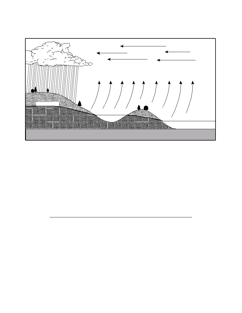
Base your answers to questions 75 through 79 on the cross section below, which shows the general pattern
of water movement in the water cycle. Letter X represents a water-cycle process.
Winds carry
Condensation and
vapor over land
cloud formation
X
Water table
Lake
Ocean
Impermeable bedrock
75 What process of the water cycle is represented by X ? [1]
76 Describe the process of condensation. [1]
77 Describe one surface condition that would allow runoff to occur. [1]
78 Explain one role of plants in the water cycle. [1]
79 As the lake surface freezes in the winter, how many calories of heat are released by
each gram of water? [1]
P.S./E. Sci.–Jan. ’08
[23]
[OVER]
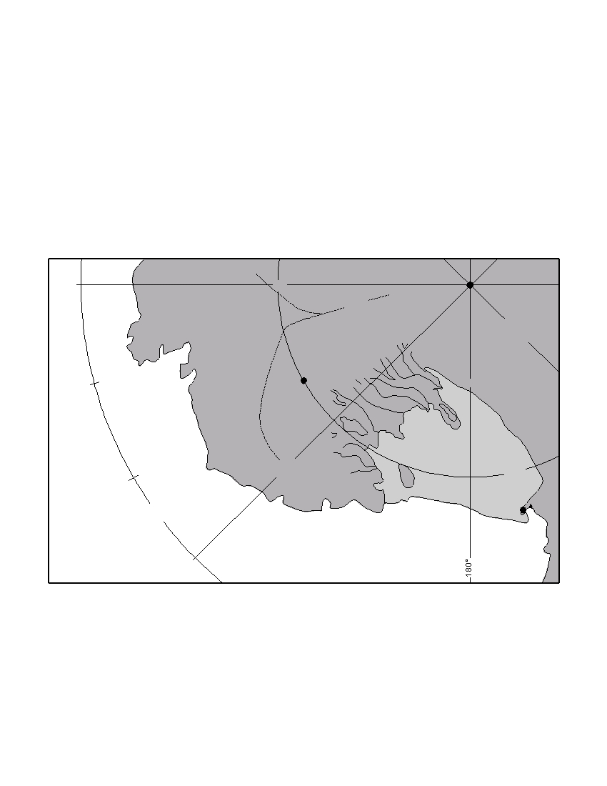
Base your answers to questions 80 through 84 on the passage and map below. The map shows a portion of
the continent of Antarctica.
Antarctica’s Ice Sheet
The size and shape of the West Antarctic Ice Sheet depends on many factors, includ-
ing melting and freezing beneath the glacier, the amount of snowfall, snow removal by
wind, iceberg formation, and the rate of ice flow. Glacial moraines are found in the
Executive Committee Mountains shown on the map. Moraines are located up to 100
meters in elevation above the present ice sheet surface, which indicates that a thicker ice
sheet existed 20,000 years ago.
The world’s oceans and climate are influenced by Antarctica’s ice. Even a small
increase in sea level from melting glaciers would be a disaster for the nearly two
billion people who live near coastal areas.
Ice
90° W
Divide
South Pole
Whitmore
Glacier
Mountains
Island
East
West
Antarctica
Pine
Antarctica
Glacier
Thwaites
T r a
Byrd
n s
W
a n
105°
Station
t a
r c
t i c
M
o
u
n
t
a
Amundsen
i n
s
Sea
Ross
Executive
Ice Shelf
Committee Mountains
80°
S
W
Roosevelt
120°
Island
70°
McMurdo
Station
S
Ross Sea
W
135°
80 Identify one piece of evidence found on the sides of some Antarctic mountains that
indicates that an ice sheet, hundreds of meters thicker than the current ice sheet,
existed in the past. [1]
81 What is the duration of insolation on December 21 at McMurdo Station? [1]
P.S./E. Sci.–Jan. ’08
[24]

82 State the latitude and longitude of Byrd Station. Your answer must include both the
units and the compass directions. [1]
83 Describe the arrangement of sediment found in a glacial moraine. [1]
84 Identify one change that would cause a decrease in the size of the West Antarctic Ice
Sheet. [1]
P.S./E. Sci.–Jan. ’08
[25]

The University of the State of New York
R EGENTS H IGH S CHOOL E XAMINATION
PHYSICAL SETTING
EARTH SCIENCE
Wednesday, January 23, 2008 — 9:15 a.m. to 12:15 p.m., only
ANSWER SHEET
Student . . . . . . . . . . . . . . . . . . . . . . . . . . . . . . . . . . . . . . . . . . . . . . .
Sex:
I Male I Female Grade . . . . . . . . . . . .
Teacher . . . . . . . . . . . . . . . . . . . . . . . . . . . . . . . . . . . . . . . . . . . . . . .
School . . . . . . . . . . . . . . . . . . . . . . . . . . . . . . . . . . . .
Record your answers to Part A and Part B–1 on this answer sheet.
Part A
Part B–1
1 . . . . . . . . . . . .
13 . . . . . . . . . . . .
25 . . . . . . . . . . .
36 . . . . . . . . . . . .
44 . . . . . . . . . . . .
2 . . . . . . . . . . . .
14 . . . . . . . . . . . .
26 . . . . . . . . . . .
37 . . . . . . . . . . . .
45 . . . . . . . . . . . .
3 . . . . . . . . . . . .
15 . . . . . . . . . . . .
27 . . . . . . . . . . .
38 . . . . . . . . . . . .
46 . . . . . . . . . . . .
4 . . . . . . . . . . . .
16 . . . . . . . . . . . .
28 . . . . . . . . . . .
39 . . . . . . . . . . . .
47 . . . . . . . . . . . .
5 . . . . . . . . . . . .
17 . . . . . . . . . . . .
29 . . . . . . . . . . .
40 . . . . . . . . . . . .
48 . . . . . . . . . . . .
6 . . . . . . . . . . . .
18 . . . . . . . . . . . .
30 . . . . . . . . . . .
41 . . . . . . . . . . . .
49 . . . . . . . . . . . .
7 . . . . . . . . . . . .
19 . . . . . . . . . . . .
31 . . . . . . . . . . .
42 . . . . . . . . . . . .
50 . . . . . . . . . . . .
Part B–1 Score
8 . . . . . . . . . . . .
20 . . . . . . . . . . . .
32 . . . . . . . . . . .
43 . . . . . . . . . . . .
9 . . . . . . . . . . . .
21 . . . . . . . . . . . .
33 . . . . . . . . . . .
10 . . . . . . . . . . . .
22 . . . . . . . . . . . .
34 . . . . . . . . . . .
11 . . . . . . . . . . . .
23 . . . . . . . . . . . .
35 . . . . . . . . . . .
Part A Score
12 . . . . . . . . . . . .
24 . . . . . . . . . . . .
Write your answers to Part B–2 and Part C in your answer booklet.
The declaration below should be signed when you have completed the examination.
I do hereby affirm, at the close of this examination, that I had no unlawful knowledge of the questions or answers prior to
the examination and that I have neither given nor received assistance in answering any of the questions during the examination.
Signature

PS/EARTH SCIENCE
E C N E I C S H T R A E / S P