
PS/EARTH SCIENCE
The University of the State of New York
REGENTS HIGH SCHOOL EXAMINATION
PHYSICAL SETTING
EARTH SCIENCE
Wednesday, August 16, 2006 — 12:30 to 3:30 p.m., only
This is a test of your knowledge of Earth science. Use that knowledge to answer
all questions in this examination. Some questions may require the use of the Earth
Science Reference Tables. The Earth Science Reference Tables are supplied separately.
Be certain you have a copy of the 2001 edition of these reference tables before you
begin the examination.
Your answer sheet for Part A and Part B–1 is the last page of this examination
booklet. Turn to the last page and fold it along the perforations. Then, slowly and
carefully, tear off your answer sheet and fill in the heading.
The answers to the questions in Part B–2 and Part C are to be written in your
separate answer booklet. Be sure to fill in the heading on the front of your answer
booklet.
You are to answer all questions in all parts of this examination according to the
directions provided in the examination booklet. Record your answers to the Part A
and Part B–1 multiple-choice questions on your separate answer sheet. Write your
answers to the Part B–2 and Part C questions in your answer booklet. All work should
be written in pen, except for graphs and drawings, which should be done in pencil.
You may use scrap paper to work out the answers to the questions, but be sure to
record all your answers on your separate answer sheet and in your answer booklet.
When you have completed the examination, you must sign the statement printed
at the end of your separate answer sheet, indicating that you had no unlawful
knowledge of the questions or answers prior to the examination and that you have
neither given nor received assistance in answering any of the questions during the
examination. Your answer sheet and answer booklet cannot be accepted if you fail to
sign this declaration.
Notice. . .
A four-function or scientific calculator and a copy of the 2001 Earth Science Reference Tables
must be available for you to use while taking this examination.
The use of any communications device is strictly prohibited when taking this
examination. If you use any communications device, no matter how briefly, your
examination will be invalidated and no score will be calculated for you.
DO NOT OPEN THIS EXAMINATION BOOKLET UNTIL THE SIGNAL IS GIVEN.
E C N E I C S H T R A E / S P
Part A
Answer all questions in this part.
Directions (1–35): For each statement or question, write on your separate answer sheet the number of the
word or expression that, of those given, best completes the statement or answers the question. Some questions
may require the use of the Earth Science Reference Tables .
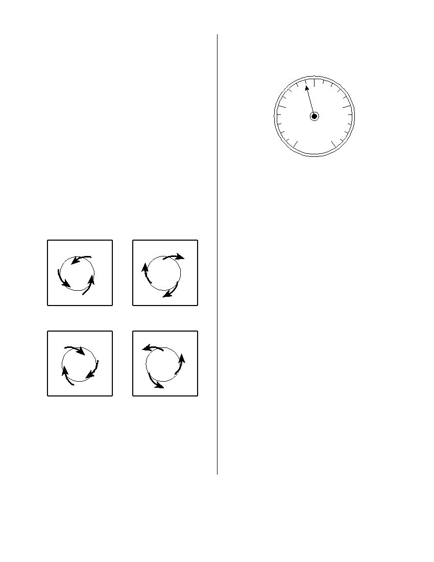
1 A Foucault pendulum appears to change its
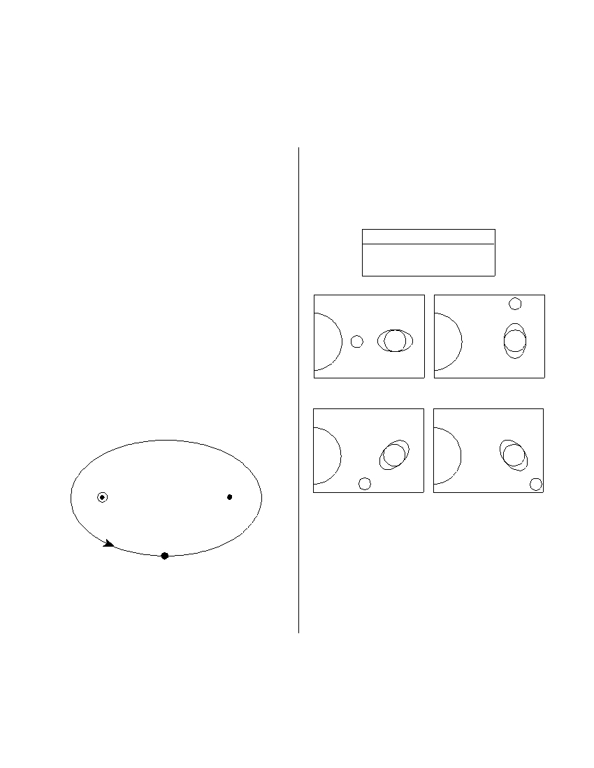
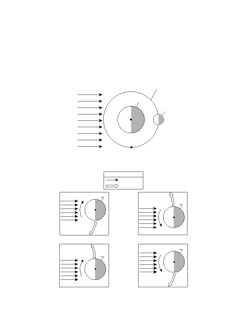
4 The diagrams below represent Earth’s ocean
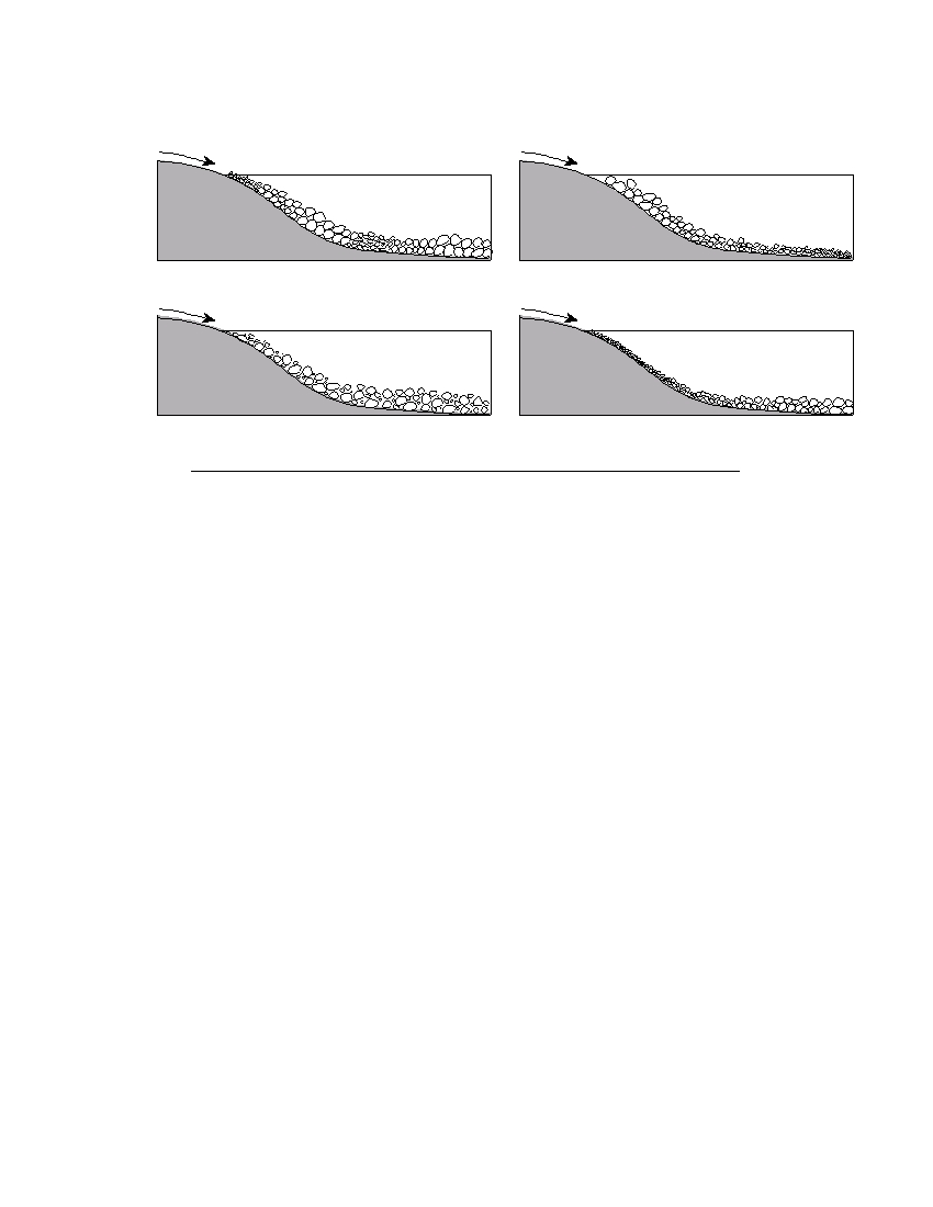
direction of swing over a period of several hours
tides at four different positions of the Moon.
because of Earth’s
Which diagram shows the Moon position that will
(1) rotation
(3) tilted axis
produce the highest high tides and the lowest low
(2) revolution
(4) gravity
tides? (The diagrams are not drawn to scale.)
2 The same side of the Moon always faces Earth
Key
because the
E = Earth
H = High tide
(1) Moon’s period of rotation is longer than its
M = Moon
L = Low tide
period of revolution around Earth
(2) Moon’s period of rotation is shorter than its
period of revolution around Earth
M
(3) Moon rotates once as it completes one
L
H
revolution around Earth
(4) Moon does not rotate as it completes one
Sun
M H
E
H
Sun
L
E
L
revolution around Earth
L
H
3 The diagram below shows the elliptical orbit of a
( 1 )
( 3 )
planet revolving around a star. The star and F 2
are the foci of this ellipse.
L
H
H
L
Sun
E
Sun
E
H
L
L
H
M
M
Star
F 2
( 2 )
( 4 )
5 From which New York State location would
Polaris be observed to have an altitude closest to
43° above the northern horizon?
(1) Binghamton
(3) Watertown
What is the approximate eccentricity of this
(2) Utica
(4) New York City
ellipse?
(1) 0.22
(3) 0.68
(2) 0.47
(4) 1.47
P.S./E. Sci.–Aug. ’06
[2]
6 In October, observers in New York State looking
10 The diagram below represents an aneroid barom-
due south at the night sky would see a different
eter that shows the air pressure, in inches of
group of constellations than they had seen in
mercury.
March. What is the best explanation for this
change in the night sky?
(1) Constellations revolve around Earth.
30.00
(2) Constellations revolve around the Sun.
(3) The Sun revolves around the center of our
galaxy.
(4) Earth revolves around the Sun.
29.00
31.00
7 Which surface soil type has the slowest perme-
ability rate and is most likely to produce flooding?
(1) pebbles
(3) silt
(2) sand
(4) clay
When converted to millibars, this air pressure is
equal to
(1) 1009.0 mb
(3) 1015.5 mb
8 Which map best represents the surface wind
(2) 1012.5 mb
(4) 1029.9 mb
pattern around a Northern Hemisphere high-
pressure center?
11 Great volcanic eruptions send dust and ash into
the stratosphere. Weeks after such great erup-
tions, air temperatures are often
(1) cooler than normal because the atmosphere is
H
H
less transparent
(2) cooler than normal because the atmosphere is
more transparent
(3) warmer than normal because the atmosphere
is less transparent
( 1 )
( 3 )
(4) warmer than normal because the atmosphere
is more transparent
12 A P -wave takes 8 minutes and 20 seconds to
travel from the epicenter of an earthquake to a
H
H
seismic station. Approximately how long will an
S -wave take to travel from the epicenter of the
same earthquake to this seismic station?
(1) 6 min 40 sec
(3) 15 min 00 sec
( 2 )
( 4 )
(2) 9 min 40 sec
(4) 19 min 00 sec
9 What is the relative humidity when the air tem-
perature is 29°C and the wet-bulb temperature is
23°C?
(1) 6%
(3) 54%
(2) 20%
(4) 60%
P.S./E. Sci.–Aug. ’06
[3]
[OVER]
Base your answers to questions 13 and 14 on the
17 The cross section below shows the direction of
weather map below, which shows a low-pressure
movement of an oceanic plate over a mantle hot
system centered near Poughkeepsie, New York.
spot, resulting in the formation of a chain of vol-
Isobars shown are measured in millibars.
canoes labeled A , B , C , and D . The geologic age
of volcano C is shown.
1004
Binghamton
8 million
1012
1000 Low
Poughkeepsie
years old
Ocean
A
B
C
D
Port Jervis
Danbury
Scranton
Plate motion
1008
New
York
City
Magma
N
from hot spot
Asthenosphere
What are the most likely geologic ages of volca-
13 Which city is most likely experiencing winds of
noes B and D ?
the greatest velocity?
(1) B is 5 million years old and D is 12 million
(1) New York City
(3) Poughkeepsie
years old.
(2) Binghamton
(4) Scranton
(2) B is 2 million years old and D is 6 million
years old.
14 Surface winds are most likely blowing from
(3) B is 9 million years old and D is 9 million
(1) Danbury toward New York City
years old.
(2) Poughkeepsie toward Scranton
(4) B is 10 million years old and D is 4 million
(3) Binghamton toward Danbury
years old.
(4) Port Jervis toward Binghamton
18 New York State landscape regions are identified
and classified primarily by their
15 Scientists have inferred the structure of Earth’s
(1) surface topography and bedrock structure
interior mainly by analyzing
(2) existing vegetation and type of weather
(1) the Moon’s interior
(3) latitude and longitude
(2) the Moon’s composition
(4) chemical weathering rate and nearness to
(3) Earth’s surface features
large bodies of water
(4) Earth’s seismic data
19 A stream flowing at a velocity of 75 centimeters
16 Which process transfers energy primarily by elec-
per second can transport
tromagnetic waves?
(1) clay, only
(1) radiation
(3) conduction
(2) pebbles, only
(2) evaporation
(4) convection
(3) pebbles, sand, silt, and clay, only
(4) boulders, cobbles, pebbles, sand, silt, and clay
P.S./E. Sci.–Aug. ’06
[4]
20 The cross sections below show a three-stage sequence in the development of a
glacial feature.
More sediments
Block of
Melting
glacial ice
ice
block
Glacial till or outwash
Stage 1
Stage 2
Stage 3
Which glacial feature has formed by the end of stage 3?
(1) kettle lake
(3) drumlin
(2) finger lake
(4) parallel scratches
21 Which diagram best shows the Sun’s apparent path, as seen by an observer on
July 21 in New York State?
Zenith
Zenith
Noon Sun
Noon Sun
West
West
J
u
yl
2
1
South
Observer
North
South
Observer
J
North
u
l y
2
1
Horizon
Horizon
East
East
( 1 )
( 3 )
Zenith
Zenith
West
Noon Sun
Noon Sun
West
South
Observer
1
North
South
Observer
North
2
J
l y
u
J u
l y
2
1
East
Horizon
East
Horizon
( 2 )
( 4 )
P.S./E. Sci.–Aug. ’06
[5]
[OVER]
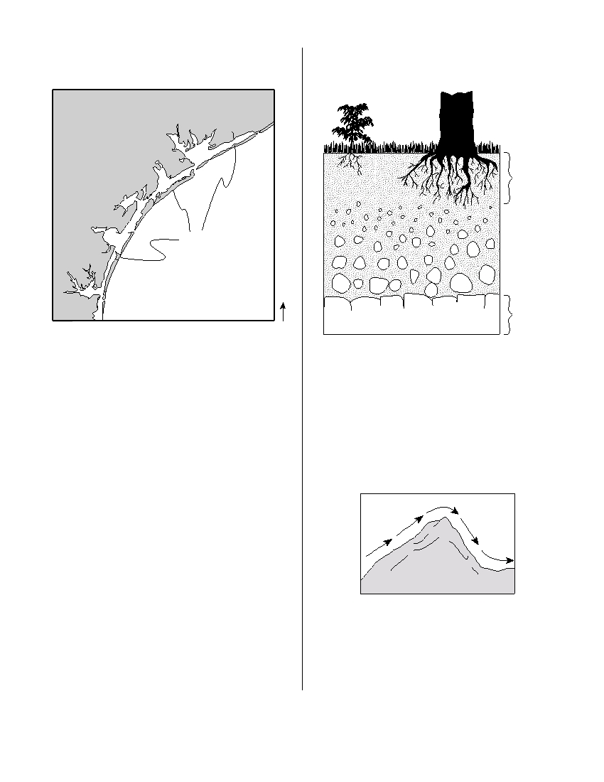
22 The map below shows barrier islands in the ocean
25 The cross section below shows soil layer X , which
along the coast of Texas.
was formed from underlying bedrock.
Texas
Soil
layer
X
Barrier islands
N
Gulf of Mexico
Bedrock
Which agent of erosion most likely formed these
barrier islands?
Which change would most likely cause soil layer X
(1) mass movement
(3) streams
to increase in thickness?
(2) wave action
(4) glaciers
(1) a decrease in slope
(2) a decrease in rainfall
(3) an increase in biologic activity
23 What will be the most probable arrangement of
(4) an increase in air pressure
rock particles deposited directly by a glacier?
(1) sorted and layered
(2) sorted and not layered
26 The diagram below shows wind flowing over a
(3) unsorted and layered
mountain range.
(4) unsorted and not layered
Windward
Leeward
24 Which two gases have been added to Earth’s
side
side
atmosphere in large amounts and are believed to
have increased global warming by absorbing
infrared radiation?
Mountain
(1) neon and argon
range
(2) chlorine and nitrogen
(3) hydrogen and helium
(4) methane and carbon dioxide
As the wind flows down the leeward side of the
mountain range, the air becomes
(1) cooler and drier
(2) cooler and wetter
(3) warmer and drier
(4) warmer and wetter
P.S./E. Sci.–Aug. ’06
[6]
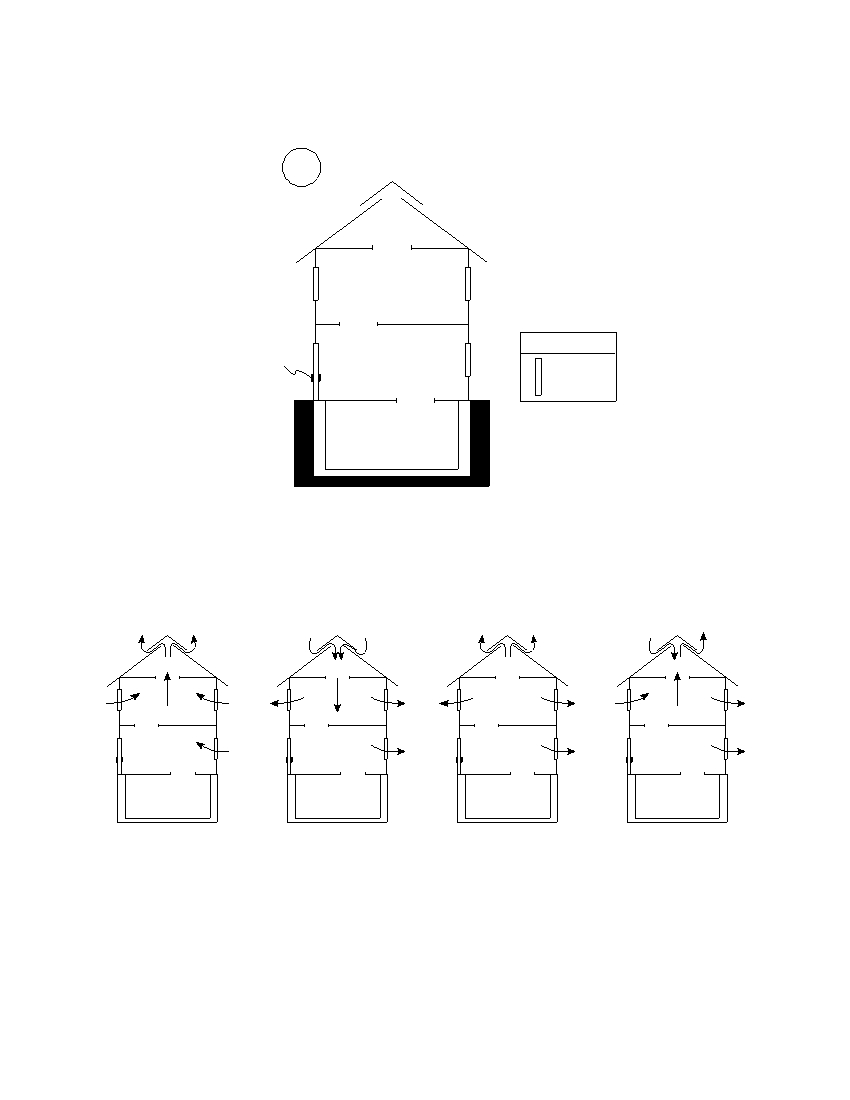
27 The cross section of a house is shown below. Open stairways allow air to move from
one floor to another. The ridge vent is an opening in the roof that allows air to move
in or out of the attic.
Sun
Ridge Vent
Attic
Second Floor
Key
Door
First Floor
Window
Basement
(Not drawn to scale)
During a windless summer day, the air inside this house is warmed by the Sun. In
which cross section do the arrows show the most likely air movement when the win-
dows are opened?
( 1 )
( 2 )
( 3 )
( 4 )
P.S./E. Sci.–Aug. ’06
[7]
[OVER]
28 The ozone layer helps life on Earth because
32 Wavy bands of light and dark minerals visible in
ozone
gneiss bedrock probably formed from the
(1) modifies the normal El Niño weather pattern
(1) cementing together of individual mineral
(2) reflects insolation from the Sun
grains
(3) absorbs damaging ultraviolet radiation from
(2) cooling and crystallization of magma
the Sun
(3) evaporation of an ancient ocean
(4) deflects winds from a straight line to a curved
(4) heat and pressure during metamorphism
path
33 The table below shows the hardness of four com-
29 Under identical conditions, which surface will
mon materials.
reflect the greatest amount of insolation?
(1) a basaltic sand beach
Hardness of Four Materials
(2) a pine tree forest
(3) a glacial ice sheet
Material
Hardness
(4) a blacktop parking lot
human fingernail
2.5
copper penny
3.0
30 The diagram below shows Earth on a particular
window glass
4.5
day in its orbit around the Sun. The dashed line
represents Earth’s axis.
steel nail
6.5
North
Pole
Which statement best describes the hardness of
the mineral dolomite?
(1) Dolomite can scratch window glass, but can-
Equator
not be scratched by a fingernail.
Sun’s
(2) Dolomite can scratch window glass, but can-
rays
not be scratched by a steel nail.
(3) Dolomite can scratch a copper penny, but
cannot be scratched by a fingernail.
(4) Dolomite can scratch a copper penny, but
cannot be scratched by a steel nail.
Which date is represented by the diagram?
(1) March 21
(3) September 23
(2) June 21
(4) December 21
31 Fossils of trilobites, graptolites, and eurypterids
are found in the same bedrock layer in New York
State. During which geologic time interval could
this bedrock layer have formed?
(1) Late Ordovician to Early Devonian
(2) Late Silurian to Early Cretaceous
(3) Early Permian to Late Jurassic
(4) Early Cambrian to Middle Ordovician
P.S./E. Sci.–Aug. ’06
[8]
34 The block diagram below of a portion of Earth’s crust shows four zones labeled A ,
B , C , and D outlined with dashed lines.
A
B
C
D
Key
Rock Units
Igneous rock
Sedimentary
rocks
Contact
metamorphism
In which zone is a younger rock unit on top of an older rock unit?
(1) A
(3) C
(2) B
(4) D
35 The graph below shows the rate of decay of the radioactive isotope K-40 into the
decay products Ar-40 and Ca-40.
100
75
50
25
0
0
1.3
2.6
3.9
5.2
6.5
Time (billion yr)
Analysis of a basalt rock sample shows that 25% of its radioactive K-40 remained
undecayed. How old is the basalt?
(1) 1.3 billion years
(3) 3.9 billion years
(2) 2.6 billion years
(4) 4.6 billion years
P.S./E. Sci.–Aug. ’06
[9]
[OVER]
Part B–1
Answer all questions in this part.
Directions (36–50): For each statement or question, write on your separate answer sheet the number of the
word or expression that, of those given, best completes the statement or answers the question. Some questions
may require the use of the Earth Science Reference Tables .
Base your answers to questions 36 and 37 on the diagram below, which shows the Moon, Earth, and the
Sun’s rays as viewed from space. Letter A indicates a certain position of the Moon in its orbit.
Moon's orbit
Earth
Moon
Light rays
North Pole
from Sun
A
(Not drawn to scale)
36 Which diagram correctly shows the direction of Earth’s rotation and revolution?
Key
Rotation
Revolution
Earth
Earth
North Pole
Light rays
from Sun
North Pole
Light rays
from Sun
( 1 )
( 3 )
Earth
Earth
North Pole
Light rays
North Pole
from Sun
Light rays
from Sun
( 2 )
( 4 )
P.S./E. Sci.–Aug. ’06
[10]

37 Which diagram represents the phase of the Moon, as seen by an observer on Earth,
when the Moon is located at position A in its orbit?
( 1 )
( 2 )
( 3 )
( 4 )
Base your answers to questions 38 through 40 on the passage below and on your knowledge of Earth
science.
A Newly Discovered Planet
Scientists studying a Sun-like star named Ogle-Tr-3 discovered a planet that is, on
the average, 3.5 million kilometers away from the star’s surface. The planet was discov-
ered as a result of observing a cyclic decrease in the brightness of Ogle-Tr-3 every 28.5
hours. The changing brightness is the result of the planet blocking some of the starlight
when it is between Ogle-Tr-3 and Earth. This observation allowed scientists to find not
only the planet, but also to determine the planet’s mass and density. The mass has been
calculated to be approximately 159 times the mass of Earth. The planet is only 20% as
dense as Jupiter. Scientists think that this low density is the result of being very close to
Ogle-Tr-3 .
38 Compared to the period of revolution of Mercury and Venus, this newly discovered
planet’s period of revolution is
(1) shorter than both Mercury’s and Venus’
(2) longer than both Mercury’s and Venus’
(3) shorter than Mercury’s but longer than Venus’
(4) longer than Mercury’s but shorter than Venus’
39 The density of the discovered planet has been estimated to be approximately
(1) 5.5 g/cm 3
(3) 1.3 g/cm 3
(2) 2.0 g/cm 3
(4) 0.3 g/cm 3
40 The planet was discovered when it passed between Earth and the star Ogle-Tr-3 .
Which event in our solar system results from a similar type of alignment of the
Moon between Earth and the Sun?
(1) summer solstice
(3) solar eclipse
(2) winter solstice
(4) lunar eclipse
P.S./E. Sci.–Aug. ’06
[11]
[OVER]
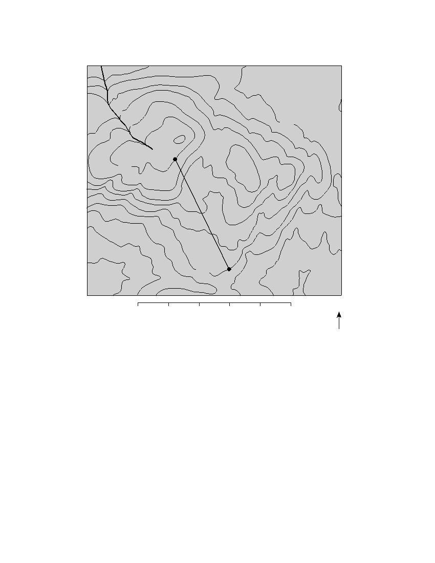
Base your answers to questions 41 through 44 on the topographic map below. Elevations are in feet. Points
A and B are locations on the map.
G
r e
e
n
R
i v
e
300
r
A
400
300
B
0
1
2
3
4
5
N
Miles
41 Toward which direction does the Green River flow?
(1) northeast
(3) southeast
(2) northwest
(4) southwest
42 What is the gradient along the straight line between points A and B ?
(1) 10 ft/mi
(3) 25 ft/mi
(2) 20 ft/mi
(4) 35 ft/mi
P.S./E. Sci.–Aug. ’06
[12]
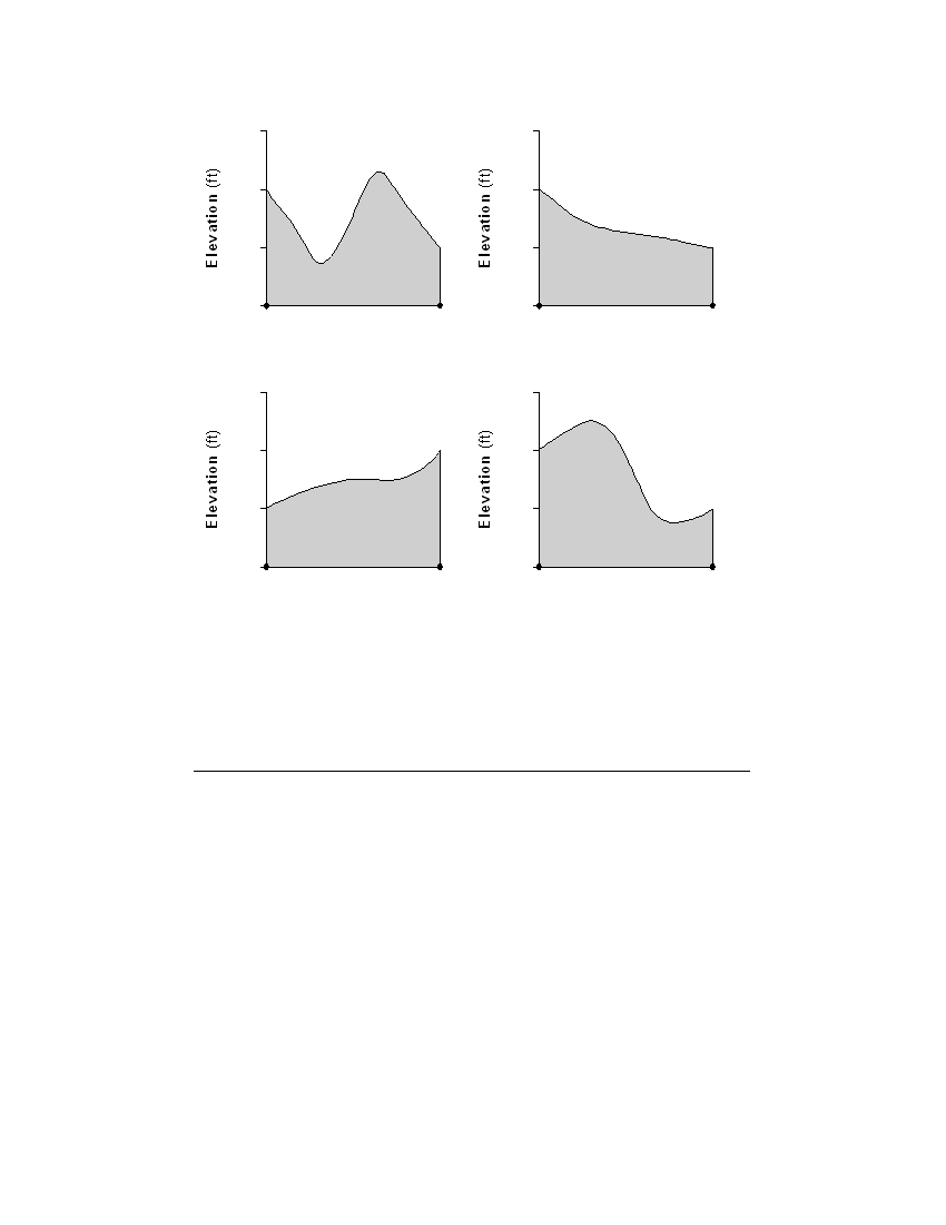
43 Which graph best represents the profile along line AB ?
500
500
400
400
300
300
200
200
A
B
A
B
Distance (mi)
Distance (mi)
( 1 )
( 3 )
500
500
400
400
300
300
200
200
A
B
A
B
Distance (mi)
Distance (mi)
( 2 )
( 4 )
44 What evidence can be used to determine that the land surface in the northeast
corner of the map is relatively flat?
(1) a rapidly flowing river
(3) the dark contour line labeled 300
(2) a large region covered by water
(4) the absence of many contour lines
P.S./E. Sci.–Aug. ’06
[13]
[OVER]
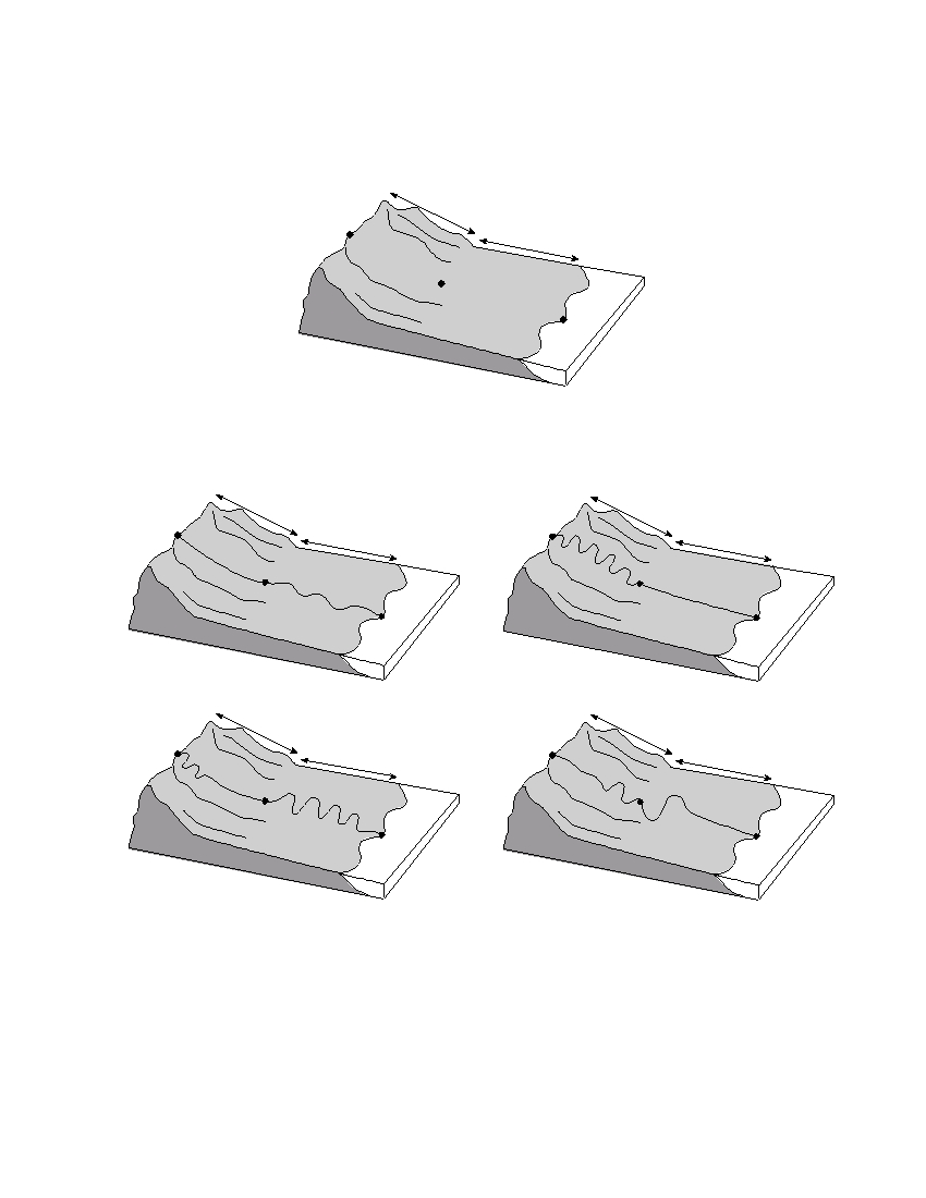
Base your answers to questions 45 through 47 on the diagram below, which shows a coastal region in which
the land slopes toward the ocean. Point X is near the top of the hill, point Y is at the base of the hill, and point
Z is a location at sea level. The same type of surface bedrock underlies this entire region. A stream flows from
point X through point Y to point Z . This stream is not shown in the diagram.
H i l l s
l o p e
X
C o a s t a l p l a i n
Y
Z
Ocean
45 Which diagram best shows the most probable path of the stream flowing from point X
to point Z ?
H i l l s
H
i l l s
l o p
e
X
l o p e
C o a s t a l p l a i n
X
C o a s t a l p l a i n
Y
Y
Z
Z
Ocean
Ocean
( 1 )
( 3 )
H i l l s
H
i l l s
l o p
e
l o p e
X
C o a s t a l p l a i n
X
C o a s t a l p l a i n
Y
Y
Z
Z
Ocean
Ocean
( 2 )
( 4 )
46 Compared to the stream velocity between point X and point Y , the stream velocity
between point Y and point Z is most likely
(1) greater, since the slope of the land decreases
(2) greater, since the slope of the land increases
(3) less, since the slope of the land decreases
(4) less, since the slope of the land increases
P.S./E. Sci.–Aug. ’06
[14]
47 Which cross section best shows the pattern of sediments deposited by the stream as
it enters the ocean near point Z ?
S t r e a m
S t r e a m
( 1 )
( 3 )
S t r e a m
S t r e a m
( 2 )
( 4 )
P.S./E. Sci.–Aug. ’06
[15]
[OVER]
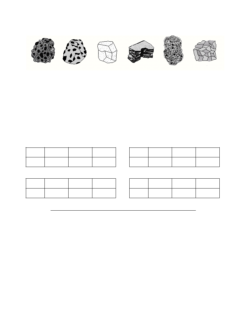
Base your answers to questions 48 through 50 on the drawings of six sedimentary rocks labeled A
through F .
A
B
C
D
E
F
Conglomerate
Breccia
Sandstone
Shale
Limestone
Rock salt
48 Most of the rocks shown were formed by
(1) volcanic eruptions and crystallization
(3) heat and pressure
(2) compaction and/or cementation
(4) melting and/or solidification
49 Which two rocks are composed primarily of quartz, feldspar, and clay minerals?
(1) rock salt and conglomerate
(3) sandstone and shale
(2) rock salt and breccia
(4) sandstone and limestone
50 Which table shows the rocks correctly classified by texture?
Texture
clastic
bioclastic
crystalline
Texture
clastic
bioclastic
crystalline
Rock
A, B, C, D
E
F
Rock
A, C
B, E
D, F
(1)
(3)
Texture
clastic
bioclastic
crystalline
Texture
clastic
bioclastic
crystalline
Rock
A, B, C
D
E, F
Rock
A, B, F
E
C, D
(2)
(4)
P.S./E. Sci.–Aug. ’06
[16]

Part B–2
Answer all questions in this part.
Directions (51–64): Record your answers in the spaces provided in your answer booklet. Some questions
may require the use of the Earth Science Reference Tables.
Base your answers to questions 51 through 53 on the passage below and on your knowledge of Earth
science.
The Future of the Sun
Hydrogen gas is the main source of fuel that powers the nuclear reactions that
occur in the Sun. But just like many sources of fuel, the hydrogen is in limited sup-
ply. As the hydrogen gas is used up, scientists predict that the helium created as an
end product of earlier nuclear reactions will begin to fuel new nuclear reactions.
When this happens, the Sun is expected to become a red giant star with a radius that
would extend out past the orbit of Venus and possibly out as far as Earth’s orbit. Earth
will probably not survive this change in the Sun’s size. But no need to worry at this
time. The Sun is not expected to expand to this size for a few billion years.
51 Identify the nuclear reaction referred to in this passage that combines hydrogen gas
to form helium and produces most of the Sun’s energy. [ 1 ]
52 On the diagram of the planets and the Sun’s surface in your answer booklet , draw a
vertical line to represent the inferred location of the Sun’s surface when it becomes
a red giant star. [ 1 ]
53 Explain why a red giant star, similar to Aldebaran , has a greater luminosity than the
Sun.
[ 1 ]
P.S./E. Sci.–Aug. ’06
[17]
[OVER]
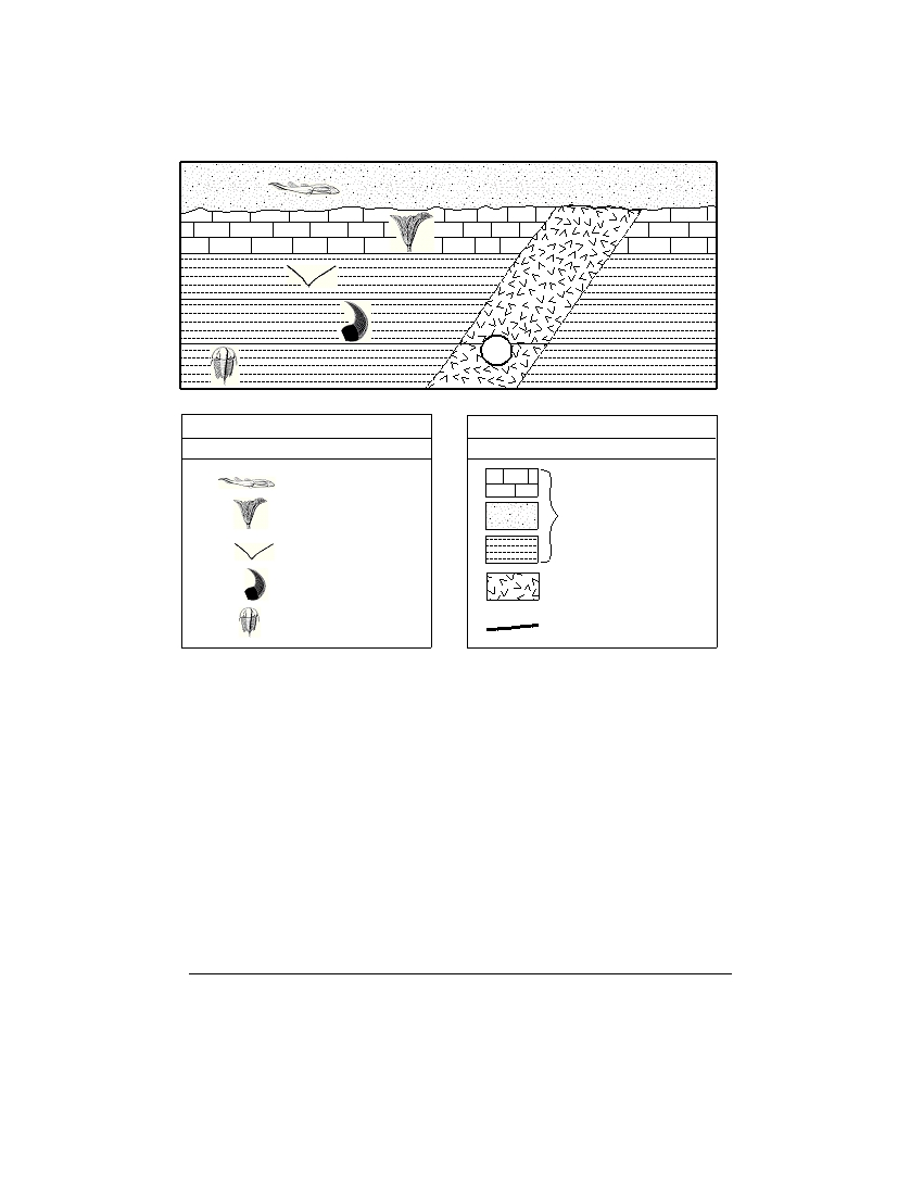
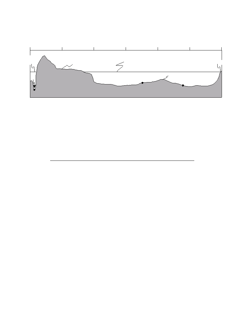
Base your answers to questions 54 through 58 on the geologic cross section below and on your knowledge
of Earth science. The cross section shows New York State index fossils in rock layers that have not been over-
turned. Rock unit A is an igneous intrusion and line XY represents an unconformity.
X
l
Y
l ll
l l l
l l
l
l l
l l
l l
l l
l l
l l
l l
l l
l l
l l
l l
l l
ll
l l
l l
l l
l l
l l
l l
l l
l l
l l
l l
A
l l
l l
l l
l l
l l
l l
l l
l l
l l
Key
Key
Index Fossils
Rock Units
Bothriolepis
Ctenocrinus
Sedimentary rocks
Dicellograptus
Valcouroceras
Igneous rock
Contact
Elliptocephala
l l l l l l l l l
metamorphic rock
54 Based on fossil evidence, determine the geologic period during which the uncon-
formity formed. [ 1 ]
55 Identify the coral index fossil that would most likely be found in the same layer as
the index fossil Ctenocrinus . [ 1 ]
56 Each index fossil existed for a relatively short geologic time interval. State one other
characteristic that each fossil must have to be considered an index fossil. [ 1 ]
57 Describe the type of depositional environment in which the fossilized organisms
lived. [ 1 ]
58 Identify one piece of evidence shown in this cross section that indicates that the
igneous intrusion, A , is older than the sandstone layer. [ 1 ]
P.S./E. Sci.–Aug. ’06
[18]

Base your answers to questions 59 through 61 on the cross section below and on your knowledge of Earth
science. The cross section shows a portion of Earth’s interior. Layer X is part of Earth’s interior.
Continental
Oceanic
crust
crust
Sea level
Lithosphere
Layer X
Plastic mantle
(Not drawn to scale)
59 Identify the texture and relative density of the granitic bedrock of the continental
crust and the basaltic bedrock of the oceanic crust. [ 2 ]
60 The minerals biotite and amphibole may be found in igneous bedrock of both the
oceanic crust and the continental crust. Identify two other minerals commonly
found in the basaltic oceanic crust. [ 1 ]
61 Identify the part of Earth’s lithosphere represented by layer X . [ 1 ]
Base your answers to questions 62 through 64 on the map in your answer booklet, which shows the gener-
alized surface bedrock for a portion of New York State that appears in the Earth Science Reference Tables.
62 Place an X on the map to represent a location in the Tug Hill Plateau landscape
region. [ 1 ]
63 State the longitude of Mt. Marcy, New York, to the nearest degree . The units and
compass direction must be included in your answer. [ 1 ]
64 Identify the geologic age and name of the surface metamorphic bedrock found at
Mt. Marcy. [ 1 ]
P.S./E. Sci.–Aug. ’06
[19]
[OVER]
Part C
Answer all questions in this part.
Directions (65–82): Record your answers in the spaces provided in your answer booklet. Some questions
may require the use of the Earth Science Reference Tables.
65 Part of which generalized New York State landscape region is drained by the
Susquehanna River and its tributaries? [ 1 ]
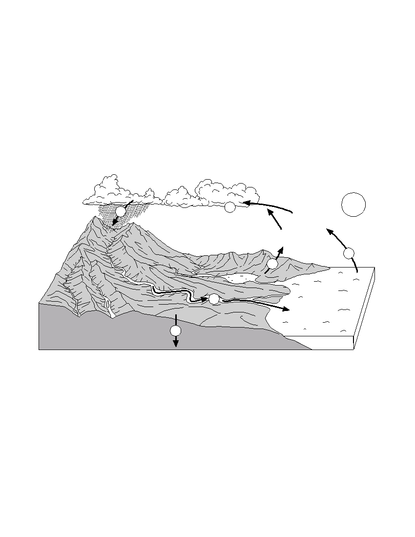
66 The diagram below shows a model of the water cycle. The arrows show the move-
ment of water molecules through the water cycle. The circled numbers represent
the processes that occur as the water molecules reach the different stages of the
water cycle.
4
3
Sun
Water vapor
from ocean
Water vapor
from plants
1
2
5
Ocean
6
Groundwater
Complete the table in your answer booklet by identifying the name of the water
cycle process occurring at each number. [ 2 ]
P.S./E. Sci.–Aug. ’06
[20]
Base your answers to questions 67 through 69 on the cross section below, which shows the major surface
features of Earth along 25° S latitude between 75° W and 15° E longitude. Points A , B , and C represent
locations on Earth’s crust.
75 ° W
60 ° W
45 ° W
30 ° W
15 ° W
0 °
15 ° E
Pacific
South
Ocean
America
Atlantic Ocean
Africa
A
Mid-ocean ridge
B
C
(Not drawn to scale)
67 Identify the crustal feature located at point A . [ 1 ]
68 Identify the tectonic plate motion that is causing an increase in the distance between
South America and Africa. [ 1 ]
69 Bedrock samples were taken at the mid-ocean ridge and points B and C . On the
grid in your answer booklet , draw a line to show the relative age of the bedrock sam-
ples between these locations. [ 1 ]
P.S./E. Sci.–Aug. ’06
[21]
[OVER]

Base your answers to questions 70 through 74 on the passage below and on your knowledge of Earth
science. The passage describes a tornado produced from a thunderstorm that moved through a portion of New
York State on May 31, 1998.
New York Tornado
A small tornado formed and moved through the town of Apalachin, New York, at
5:30 p.m., producing winds between 40 and 72 miles per hour. The tops of trees were
snapped off, and many large limbs fell to the ground. The path of the destruction mea-
sured up to 200 feet wide. At 5:45 p.m., the tornado next moved through the town of
Vestal where winds ranged between 73 and 112 miles per hour. Many people experi-
enced personal property damage as many homes were hit with flying material.
At 6:10 p.m., the tornado moved close to Binghamton, producing winds between
113 and 157 miles per hour. A 1000-foot television tower was pushed over, and many
heavy objects were tossed about by the strong winds. Then the tornado lifted off the
ground for short periods of time and bounced along toward the town of Windsor. At
6:15 p.m., light damage was done to trees as limbs fell and small shallow-rooted trees
were pushed over in Windsor.
The tornado increased in strength again at 6:20 p.m. as it moved into Sanford.
Some homes were damaged as their roof shingles and siding were ripped off. One
mobile home was turned over on its side.
The tornado moved through the town of Deposit at 6:30 p.m., creating a path of
destruction 200 yards wide. The tornado skipped along hilltops, touching down occa-
sionally on the valley floors. However, much damage was done to homes as the tor-
nado’s winds reached their maximum speeds of 158 to 206 miles per hour. The tor-
nado weakened and sporadically touched down after leaving Deposit. By 7:00 p.m.,
the tornado had finally ended its 1 2 -hour rampage.
1
70 On the map in your answer booklet , draw the path of the tornado and the direction
the tornado moved, by following the directions below. [ 2 ]
passage.
movement.
71 The tornado mentioned in this passage was produced by cold, dry air from Canada
quickly advancing into warm, moist air already in place over the northeastern United
States. List the two-letter air-mass symbols that would identify each of the two air
masses responsible for producing this tornado. [ 1 ]
72 Which type of front was located at the boundary between the advancing cold, dry air
mass and the warm, moist air mass? [ 1 ]
P.S./E. Sci.–Aug. ’06
[22]

73 Using the Fujita Scale shown below and the information in the passage, complete
the table in your answer booklet , by assigning an F-Scale number for the tornado as
it passed through each town given in the table. [ 1 ]
Fujita Scale
F-Scale
Wind Speed
Type of Damage Done
Number
(mph)
some damage to chimneys; breaks branches off trees; pushes over
F–0
40–72
shallow-rooted trees; damages sign boards
F–1
73–112
peels surface off roofs; mobile homes pushed off foundations or overturned;
moving autos pushed off the roads; attached garages may be destroyed
considerable damage; roofs torn off frame houses; mobile homes
F–2
113–157
demolished; boxcars pushed over; large trees snapped or uprooted;
light-object missiles generated
F–3
158–206
roof and some walls torn off well-constructed homes; trains overturned;
most trees in forest uprooted
F–4
207–260
well-constructed houses leveled; structures with weak foundations blown off
some distance; cars thrown and large missiles generated
strong frame houses lifted off foundations and carried considerable
F–5
261–318
distances to disintegrate; automobile-sized missiles fly through the air in
excess of 100 meters; trees debarked; steel-reinforced concrete structures
badly damaged
74 Calculate the tornado’s average rate of travel, in miles per minute, between Vestal and
Windsor, by using the equation below. Express your answer to the nearest tenth . [ 1 ]
distance between Vestal and Windsor (miles)
tornado’s rate of travel =
time (minutes)
P.S./E. Sci.–Aug. ’06
[23]
[OVER]
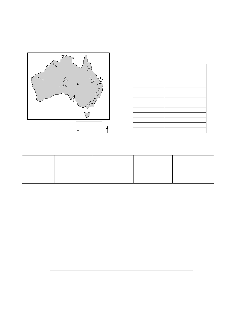
Base your answers to questions 75 through 79 on the map and data tables below. The map shows the loca-
tion of Birdsville and Bundaberg in Australia. Data table 1 shows the average monthly high temperatures for
Birdsville. Data table 2 includes the latitude and longitude, elevation above sea level, and the average rainfall
in January for Birdsville and Bundaberg.
Map of Australia
Data Table 1
Indian
Pacific
Average Monthly High Temperatures
Ocean
Ocean
for Birdsville, Australia
Month
Temperature ( ° C)
Bundaberg
January
39
Birdsville
February
38
March
35
April
30.5
May
25
June
22
July
21
August
23.5
September
28
October
32.5
Key
N
November
36
Mountains
December
38
Data Table 2
Information about Two Australian Cities
Average January
City
Latitude (° S)
Longitude (° E)
Elevation (m)
Rainfall (mm)
Birdsville
25.9
139.4
47
25
Bundaberg
24.9
152.4
14
105
75 On the grid in your answer booklet , plot with an X the average monthly high
temperatures for Birdsville, Australia. Connect the X s with a line. The average
monthly high temperatures for Bundaberg have already been plotted on the graph
for you. [ 1 ]
76 State one factor that could account for the difference between the average high
temperatures recorded in December for Birdsville and Bundaberg. [ 1 ]
77 State one reason for the difference in the average January rainfall for Birdsville and
Bundaberg. [ 1 ]
78 Explain why Bundaberg will experience solar noon before Birdsville each day. [ 1 ]
79 On the map in your answer booklet , draw the 30° S latitude line. [ 1 ]
P.S./E. Sci.–Aug. ’06
[24]

Base your answers to questions 80 through 82 on the passage below and on your knowledge of Earth
science.
Asteroids
Most known asteroids are found orbiting the Sun approximately halfway between
the orbits of Mars and Jupiter, in a vast ring known as the Asteroid Belt. Occasionally,
though, an asteroid leaves this orbit belt and moves into a more eccentric orbit that
brings it into the inner solar system. This sudden change may be caused by an impact
with another asteroid or by the gravitational pull of Jupiter or Mars.
The closest known near-Earth collision was in 1994, when asteroid 1994 XL1 came
within the Moon’s orbit at a distance of 100,000 kilometers from Earth. Earth had
missed hitting this asteroid by a mere 52 minutes. This asteroid was only about 15
hours away from Earth when it was first noticed. Only 30 feet in diameter, 1994 XL1
was 100,000 times fainter than an object that could be seen with the naked eye. Each
year other asteroids are spotted coming close to Earth.
Evidence on Earth indicates that some asteroids have come close enough to be
drawn into Earth by gravitational attraction. A 110-mile-wide crater discovered by oil
geologists under the Yucatan Peninsula and the Gulf of Mexico is one such piece of
evidence. This crater is closely linked to the extinction of the dinosaurs. Some scien-
tists estimate that a 10-mile-wide asteroid caused this crater.
80 Approximately how many million kilometers from the Sun is the Asteroid Belt? [ 1 ]
81 State one probable reason why asteroid 1994 XL1 was so close to Earth before being
spotted by astronomers. [ 1 ]
82 Some scientists believe an asteroid impact on Earth caused the extinction of the last
of the dinosaurs. How many million years ago did this asteroid impact occur? [ 1 ]
P.S./E. Sci.–Aug. ’06
[25]

The University of the State of New York
R EGENTS H IGH S CHOOL E XAMINATION
PHYSICAL SETTING
EARTH SCIENCE
Wednesday, August 16, 2006 — 12:30 to 3:30 p.m., only
ANSWER SHEET
Student . . . . . . . . . . . . . . . . . . . . . . . . . . . . . . . . . . . . . . . . . . . . . . .
Sex:
I Male I Female
Grade . . . . . . . . . . . .
Teacher . . . . . . . . . . . . . . . . . . . . . . . . . . . . . . . . . . . . . . . . . . . . . . .
School . . . . . . . . . . . . . . . . . . . . . . . . . . . . . . . . . . . .
Record your answers to Part A and Part B–1 on this answer sheet.
Part A
Part B–1
1 . . . . . . . . . . . .
13 . . . . . . . . . . . .
25 . . . . . . . . . . .
36 . . . . . . . . . . . .
44 . . . . . . . . . . . .
2 . . . . . . . . . . . .
14 . . . . . . . . . . . .
26 . . . . . . . . . . .
37 . . . . . . . . . . . .
45 . . . . . . . . . . . .
3 . . . . . . . . . . . .
15 . . . . . . . . . . . .
27 . . . . . . . . . . .
38 . . . . . . . . . . . .
46 . . . . . . . . . . . .
4 . . . . . . . . . . . .
16 . . . . . . . . . . . .
28 . . . . . . . . . . .
39 . . . . . . . . . . . .
47 . . . . . . . . . . . .
5 . . . . . . . . . . . .
17 . . . . . . . . . . . .
29 . . . . . . . . . . .
40 . . . . . . . . . . . .
48 . . . . . . . . . . . .
6 . . . . . . . . . . . .
18 . . . . . . . . . . . .
30 . . . . . . . . . . .
41 . . . . . . . . . . . .
49 . . . . . . . . . . . .
7 . . . . . . . . . . . .
19 . . . . . . . . . . . .
31 . . . . . . . . . . .
42 . . . . . . . . . . . .
50 . . . . . . . . . . . .
Part B–1 Score
8 . . . . . . . . . . . .
20 . . . . . . . . . . . .
32 . . . . . . . . . . .
43 . . . . . . . . . . . .
9 . . . . . . . . . . . .
21 . . . . . . . . . . . .
33 . . . . . . . . . . .
10 . . . . . . . . . . . .
22 . . . . . . . . . . . .
34 . . . . . . . . . . .
11 . . . . . . . . . . . .
23 . . . . . . . . . . . .
35 . . . . . . . . . . .
Part A Score
12 . . . . . . . . . . . .
24 . . . . . . . . . . . .
Write your answers to Part B–2 and Part C in your answer booklet.
The declaration below should be signed when you have completed the examination.
I do hereby affirm, at the close of this examination, that I had no unlawful knowledge of the questions or answers prior to
the examination and that I have neither given nor received assistance in answering any of the questions during the examination.
Signature

PS/EARTH SCIENCE
E C N E I C S H T R A E / S P