Climate Change and Future Impacts (HS-ESS3-5): Analyze geoscience data and the results from global climate models to make an evidence-based forecast of the current rate of global or regional climate change and associated future impacts to Earth Systems.
Analyzing geoscience data and results from global climate models involves making evidence-based forecasts of current global or regional climate change rates and their future impacts on Earth systems. This analysis helps predict how climate change will affect various environmental factors, such as temperature, precipitation patterns, and sea levels, and assess potential consequences for ecosystems, weather events, and human activities.
Main concepts:
- Analyzing geoscience data is a critical step in making evidence-based forecasts about the current rate of global or regional climate change and associated future impacts. Geoscientists use a range of techniques and tools to study the Earth's climate and environment, including analyzing atmospheric, oceanic, and terrestrial data, and monitoring trends in temperature, precipitation, sea level, ice cover, and other factors.
- Global climate models (GCMs) are a type of computer simulation used to simulate Earth's climate system and to make projections of future climate change. These models use mathematical equations to represent the various processes and feedback mechanisms that govern the Earth's climate, including the interactions between the atmosphere, oceans, and land surface.
- Climate change impacts can include changes in precipitation and temperature patterns, sea level rise, melting of glacial ice volumes, and changes in the composition of the atmosphere and ocean. These impacts can have far-reaching consequences for human societies and natural ecosystems. For example, sea level rise can lead to flooding in coastal communities and loss of coastal wetlands, while changes in temperature and precipitation can affect crop yields and water resources.
- Geoscientists are working to improve our understanding of the drivers of climate change and the potential impacts of these changes. By analyzing geoscience data and developing more sophisticated climate models, scientists can better predict the future impacts of climate change and inform policies and actions to mitigate and adapt to these impacts.
NGSS Aligned Testing Question
The map below shows some information about the change in Arctic Ocean ice extent. Line X–Y is a reference line.
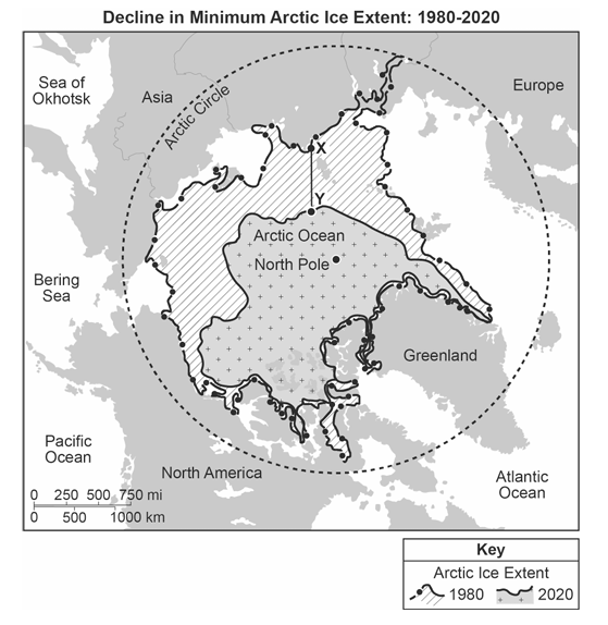
| Which claim identifies the current rate of Arctic ice change along line X–Y and its effect on the North Pole? | |
|---|---|
| 1 | In the next two years, the North Pole will most likely be ice-free because the rate of decline in the last 40 years is 12.5 mi/yr. |
| 2 | In the next five years, the North Pole will still be covered in ice because the rate of decline in the last 40 years is approximately 12.5 mi/yr. |
| 3 | In the next ten years, the North Pole will most likely be ice-free because the rate of decline in the last 40 years is 12.5 km/yr. |
| 4 | In the next fifty years, the North Pole will most likely still be covered in ice because the rate of change over the last 40 years is approximately 12.5 km/yr. |
Question and Answer Section:
- Why is analyzing geoscience data important in forecasting future climate change impacts? Answer: Analyzing geoscience data provides evidence that can be used to make accurate forecasts of the current rate of global or regional climate change and associated future impacts.
- What are global climate models? Answer: Global climate models are computer simulations that simulate Earth's climate system and project future climate change.
- What are some examples of climate change impacts? Answer: Examples of climate change impacts include changes in precipitation and temperature, sea level rise, melting of glacial ice volumes, and changes in the composition of the atmosphere and ocean.
- What is the importance of evidence-based forecasting? Answer: Evidence-based forecasting ensures that decisions are made based on accurate and reliable data.
- How can geoscience data be used to analyze climate change? Answer: Geoscience data can be used to analyze climate change by providing evidence of past and current climate conditions, and by identifying trends and patterns in climate data.
- Why are climate models used to make projections of future climate change? Answer: Climate models are used to make projections of future climate change because they allow scientists to simulate Earth's climate system and to make predictions based on different scenarios.
- What is the relationship between climate change and sea level rise? Answer: Climate change can cause sea level rise by melting glaciers and ice sheets, and by causing the thermal expansion of seawater.
- What are some ways in which climate change can impact the atmosphere and ocean? Answer: Climate change can impact the atmosphere and ocean by causing changes in the composition of the atmosphere, including increased greenhouse gas concentrations, and changes in ocean circulation patterns and acidity.
- Why is it important to consider regional impacts of climate change? Answer: It is important to consider regional impacts of climate change because different regions will experience different effects of climate change, and these effects can have significant economic, social, and environmental consequences.
- What can be done to mitigate the impacts of climate change? Answer: Mitigating the impacts of climate change requires reducing greenhouse gas emissions, increasing the use of renewable energy sources, improving energy efficiency, and adapting to the impacts of climate change that are already occurring.
*continue your studies by accessing another review sheet below*
Space Systems: HS-ESS1-1 : HS-ESS1-2 : HS-ESS1-3 : HS-ESS1-4 : HS-ESS1-7
History of the Earth: HS-ESS1-5 : HS-ESS1-6 : HS-ESS2-1
Earth's Systems: HS-ESS2-2 : HS-ESS2-3 : HS-ESS2-5 : HS-ESS2-6 : HS-ESS2-7
Weather and Climate: HS-ESS2-4 : HS-ESS3-5 : HS-ESS2-8
Human Sustainability: HS-ESS3-1 : HS-ESS3-2 : HS-ESS3-3 : HS-ESS3-4 : HS.ESS3-6
Disclaimer: The information provided is intended to serve as a study guide based on a contextual analysis of the NGSS standards for the Earth and Space Science assessment. These study guides should be used as a supplement to your overall study strategy, and their alignment to the actual test format is not guaranteed. We recommend that you consult with your instructor for additional guidance on exam preparation.